
 California Highways:
[Click here for a key to the symbols used. Some county routes were constructed with federal funds. These routes are indicated as FAP (Federal Aid Primary), FAU (Federal Aid Urban), or FAS (Federal Aid Secondary). If no funding source is shown, no federal funds were used. Note that while some segments seem to have the same attributes, they may differ in the county-local road number assigned to the segment, or in the Caltrans Map Sheet number.]
 Routing
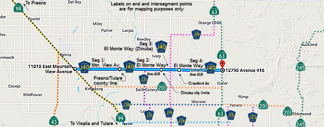 Mountain View Avenue from Route 99 to the Tulare county line (FAS, 5.20 mi) [Fresno
County]
Mountain View Avenue from Route 99 to the Tulare county line (FAS, 5.20 mi) [Fresno
County]
El Monte Way (Avenue 416) from the Fresno county line to the Dinuba city limits (FAS, 5.67 mi) [Tulare County]
El Monte Way in Dinuba from the Dinuba city limits to Crawford Avenue (Road 88) (FAU, 1.23 mi) [Tulare County]
El Monte Way (Avenue 416) from Crawford Avenue (Road 88) to Route 63 (FAS, 5.09 mi) [Tulare County]
 History and Signage Information
This route was defined in 1974.
The continuation of Ave 416 from Orosi E was originally part of LRN 130, although it does not appear to be part of County Sign Route J40.
Mountain View Avenue east of US 99 to Zediker Avenue was a minor roadway
as of 1935. El Monte Way east of Road 40 to Orosi was a major county
highway as of 1935; however, El Monte Way west of Road 40 lacked a bridge
over the Kings River to Mountain View Avenue. The original bridge over the
Kings River was completed during 1948 and connected El Monte Way to
Mountain View Avenue. The Kings River Bridge permitted Dinuba
traffic with direct access to US 99, which at the time was located on
Golden State Boulevard. Fresno/Tulare County Sign Route J40 was defined in 1974 with a
17.19-mile length. County Sign Route J40 began at Route 99 between Selma and
Kingsburg. From Route 99 the routing of J40 followed Mountain View
Avenue and El Monte Way to Route 63 in Orosi. During the 1990s, Tulare
County began to deemphasize and remove County Sign Route shields. El
Monte Way outside of Dinuba became Avenue 416. The only known County Sign
Route shields left in Tulare County are from County Sign Route J37 along Balch Park Road
(Mountain Road 239). In 2014, a new four lane Kings River Bridge was
constructed to replace the original 1948 span. The widening of
Mountain View Avenue west of the Kings River Bridge to Golden State
Boulevard (former US 99) was completed between 2016-2018. At some
point between 2018-2022, the Fresno County Department of Transportation
placed a new County Sign Route J40 shield on eastbound Mountain View Avenue.
(Source: Gribblenation Blog (Tom Fearer), "Fresno/Tulare County Route J40", 8/14/2023)
 Other WWW Links
 Status
Total mileage: 17.19 mi.
© 1996-2020 Daniel P. Faigin.
Maintained by: Daniel P. Faigin
<webmaster@cahighways.org>.
 CR J38
 CR J41