
 California Highways:
[Click here for a key to the symbols used. Some county routes were constructed with federal funds. These routes are indicated as FAP (Federal Aid Primary), FAU (Federal Aid Urban), or FAS (Federal Aid Secondary). If no funding source is shown, no federal funds were used. Note that while some segments seem to have the same attributes, they may differ in the county-local road number assigned to the segment, or in the Caltrans Map Sheet number.]
 Routing
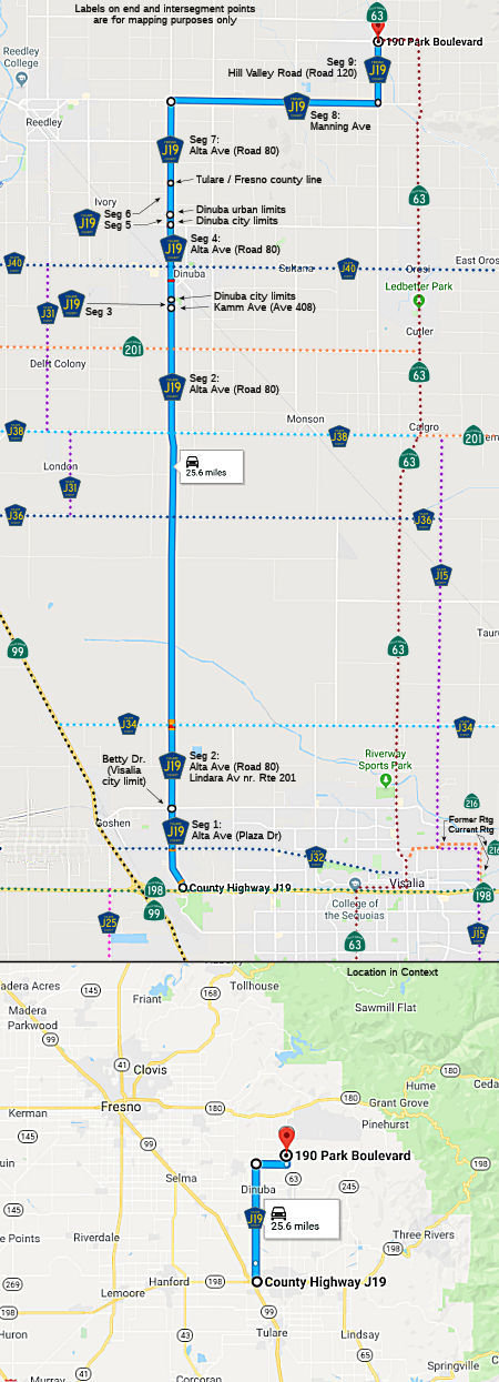 Alta Avenue (Plaza Drive) in Visalia from Route 198 to the Visalia city limits (Betty
Drive) (FAU, 1.49 mi) [Tulare County]
Alta Avenue (Plaza Drive) in Visalia from Route 198 to the Visalia city limits (Betty
Drive) (FAU, 1.49 mi) [Tulare County]
Alta Avenue (Road 80) from the Visalia city limits (Betty Drive) to Kamm Avenue (Avenue 408) (FAS, 12.51 mi) [Tulare County].
Note: The route changes name from Plaza Drive to Alta Ave/Road 80 at Avenue 320. Alta Ave appears to last only for a few blocks, with Road 80 taking over. Between Avenue 384 and Route 201, it also appears to be Lindara Ave.
Alta Avenue (Road 80) from Kamm Avenue (Avenue 408) to the Dinuba city limits (FAU, 0.38 mi) [Tulare County].
Note: Avenue 406 actually appears to be the city limits of Dinuba, not Kamm Ave (Ave. 408). The city limits of Dinuba may have changed since the route definition.
Alta Avenue (Road 80) in Dinuba (Ave 408 to Ave 424) (FAU, 1.08 mi) [Tulare County]
Alta Avenue (Road 80) from the Dinuba city limits (Avenue 424) to the Dinuba urban limits (Approx. Ave 426) (FAU, 0.14 mi) [Tulare County]
Alta Avenue (Road 80) from the Dinuba urban limits to the Fresno county line (Appx Floral Ave) (FAS, 1.55 mi) [Tulare County]
Alta Avenue (Road 80) from the Tulare county line to Manning Avenue (FAS, 2.00 mi) [Fresno County]
Manning Avenue from Alta Avenue to Hill Valley Road (Road 120) (FAS, 5.00 mi) [Fresno County]
Hill Valley Road (Road 120) from Manning Avenue to Sumner Avenue (Route 63) (FAS, 1.50 mi) [Fresno County]
 History and Signage Information
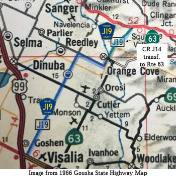 This route was defined in 1964. It originally continued all the way to Route 180, along present-day Route 63. In 1965, Chapter 1372 deleted the portion
of Route 63 (former LRN 130) from Orosi to Route 69 (present-day Route 245), and transferred the portion of former Route 226 (also part of LRN 132) from Orosi to Orange Cove to Route 63. It also transferred a portion
of County Sign Route J19 from Orange Cove to Route 180 to the route, making the last
segment of Route 63 "Route 198 to Route 180 via the vicinity of Orosi and
Orange Cove." The deleted portion is now County Sign Route J40, also known as Avenue 416
and Boyd Drive.
This route was defined in 1964. It originally continued all the way to Route 180, along present-day Route 63. In 1965, Chapter 1372 deleted the portion
of Route 63 (former LRN 130) from Orosi to Route 69 (present-day Route 245), and transferred the portion of former Route 226 (also part of LRN 132) from Orosi to Orange Cove to Route 63. It also transferred a portion
of County Sign Route J19 from Orange Cove to Route 180 to the route, making the last
segment of Route 63 "Route 198 to Route 180 via the vicinity of Orosi and
Orange Cove." The deleted portion is now County Sign Route J40, also known as Avenue 416
and Boyd Drive.
(Source for supporting info and base map graphic:
Gibblenation Blog, "California State Route 63")
Scott Parker on AARoads noted: Originally County Sign Route J19, when fully signed, was
a major "cutoff" route for traffic from southward Route 99 (US and CA) to
General Grant and Kings Canyon, particularly after Route 99 became a
free-flow road north of Bakersfield. Its southern terminus was at Route 198 immediately east of the Route 99 interchange -- in fact, there was a
"to J19" sign on NB Route 99 up until Tulare County started removing the
pentagons in the late '80's; control cities of Dinuba and Orange Cove were
listed on the roadside BGS. If the destination was along the eastern
portion of Route 180, one could remain on Route 99 much longer and avoid
both the slog through Lindsay and Exeter on Route 65 as well as the myriad
of hairpin turns on Pre-1964 Route 65 (later Route 69 and then Route 245)
south of Route 180. Somewhat longer in terms of mileage but a hell of a
lot faster than a straight shot up Route 65/Route 245.
(Source: Scott Parker on AARoads, "Re: CA 63", 11/9/2019)
As part of the 1964 State Highway Renumbering, what was LRN 132 between
Orosi and Orange Cove was renumbered as Route 226. Route 226 was a
short-lived designation as it was consolidated with Route 63 in 1965. That
same legislation also annexed County Sign Route J19 north of Park Boulevard/Sumner Avenue
as part of Route 63. Hill Valley Road north of Orange Cove became
part of Route 63 by 1969, when the road was improved to state standards.
The extension of Route 63 truncated County Sign Route J19 to Orange Cove.
(Source: Gribblenation Blog (Tom Fearer), "Tulare/Fresno County Route J19", 11/14/2023)
Beginning in the 1980s Tulare County began to deemphasize the Letter
County Routes. This culminated in all Letter County Route signage in
Tulare County being removed by modern times with the lone exception being
County Sign Route J37 on Balch Park Road. Within Fresno County signage of County Sign Route J19
lingered on but as 2023, only two known signs remain.
(Source: Gribblenation Blog (Tom Fearer), "Tulare/Fresno County Route J19", 11/14/2023)
 Status
Total mileage: 25.65 mi.
 Other WWW Links
© 1996-2020 Daniel P. Faigin.
Maintained by: Daniel P. Faigin
<webmaster@cahighways.org>.
 CR J18
 CR J20