
 California Highways:
[Click here for a key to the symbols used. Some county routes were constructed with federal funds. These routes are indicated as FAP (Federal Aid Primary), FAU (Federal Aid Urban), or FAS (Federal Aid Secondary). If no funding source is shown, no federal funds were used. Note that while some segments seem to have the same attributes, they may differ in the county-local road number assigned to the segment, or in the Caltrans Map Sheet number.]
 Routing
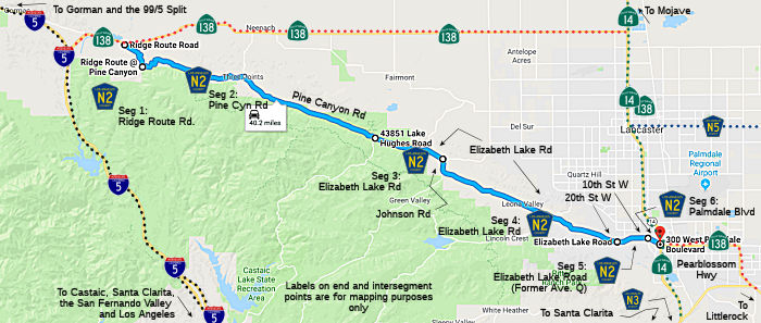 Ridge Route Road from Route 138 to Pine Canyon Road (2.00 mi)
Note: This section is the only section with N2 signage. You can see aspects of the old ridge route while driving it.
Pine Canyon Road from Ridge Route Road to Elizabeth Lake Road (16.90 mi)
The segment of Pine Canyon Road from Ridge Route Road to Three Points is poorly maintained, extremely winding (like the Ridge Route), and the only reassurance signage that you are on N2 are the county red-tipped postmiles and the Maintenance signage just W of Three Points Road. When approaching Three Points travelling W, one thinks Three Points Road is County Sign Route N2, because signage shows Route 138 as 3 miles away, but the poor maintenance gives Three Points away as being the wrong road. If you want N2, go the 8+ mi. W along Pine Canyon.
Similarly, the only clue that Pine Canyon Road is County Sign Route N2 when going W on Elizabeth Lake is that the Lake Hughes Road is signed to Castaic, whereas Pine Canyon is to Gorman. However, Pine Canyon Road between Elizabeth Lake and 3 Points is well maintained.
Elizabeth Lake Road from Pine Canyon Road to Johnson Road (4.40 mi)
Elizabeth Lake Road from Johnson Road to 20th Street West (FAS, 13.22 mi)
Elizabeth Lake Road (former Avenue Q) from 20th Street West to 10th Street West (FAS, 1.00 mi)
Palmdale Blvd in Palmdale from 10th Street West to Route 14 (FAU, 0.90 mi)
 History and Signage Information
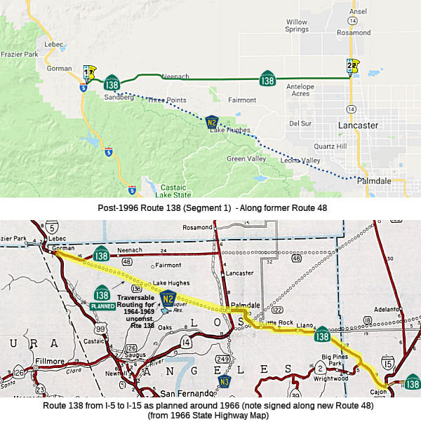 Los Angeles County Sign Route N2 is an approximately 38.42 mile Signed
County Route that straddles the Sierra Pelona Mountains above Antelope
Valley of the Mojave Desert. County Sign Route N2 dates back to 1963 and was plotted
along the planned corridor realignment of Route 138 that never was
constructed. County Sign Route N2 is also notable for incorporating part of the original
path of US 99 on the Old Ridge Route and mostly being aligned directly
over the San Andreas Fault.
Los Angeles County Sign Route N2 is an approximately 38.42 mile Signed
County Route that straddles the Sierra Pelona Mountains above Antelope
Valley of the Mojave Desert. County Sign Route N2 dates back to 1963 and was plotted
along the planned corridor realignment of Route 138 that never was
constructed. County Sign Route N2 is also notable for incorporating part of the original
path of US 99 on the Old Ridge Route and mostly being aligned directly
over the San Andreas Fault.
(Source: Gribblenation Blog - Los Angeles County Route N2)
As a county sign route, this route was defined in 1963. However, it is much older than that. In 1919, the third highway bond act established a state highway between Bailey's (near what is now Gorman) and Lancaster. It was an E-W routing from near Gorman to N of Lancaster, passing through Neenach. It was LRN 59, and was signed as Route 138 after 1934. After 1959, a new routing for LRN 59 from about 10 mi E of Gorman through Lake Hughes directly to Palmdale was defined for Route 138 ("Metropolitan Bypass"), and the older routing from that point to Lancaster was renumbered LRN 267. The traversable routing for 1959-1963 LRN 59 was what is now County Sign Route N2. Post 1964, the LRN 267 routing was renumbered as legislative Route 48, although it was signed as Route 138 (presumably, that signage would move once the freeway bypass was completed). However, in 1996, the Route 138 to Lancaster portion of Route 48 was returned to Route 138, essentially restoring Route 138 back to the original LRN 59 routing (and leaving the traversable equivalent of the "new" LRN 59 as County Sign Route N2).
 Other WWW Links
 Status
Total mileage: 38.42 mi. Much of this route follows the San Andreas Fault.
© 1996-2020 Daniel P. Faigin.
Maintained by: Daniel P. Faigin
<webmaster@cahighways.org>.
 CR N1
CR N1 CR N3
CR N3