
 California Highways:
[Click here for a key to the symbols used. Some county routes were constructed with federal funds. These routes are indicated as FAP (Federal Aid Primary), FAU (Federal Aid Urban), or FAS (Federal Aid Secondary). If no funding source is shown, no federal funds were used. Note that while some segments seem to have the same attributes, they may differ in the county-local road number assigned to the segment, or in the Caltrans Map Sheet number.]
 Routing
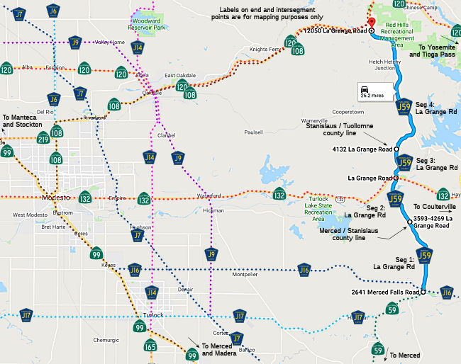 La Grange Road from Route 59 to the Stanislaus county line (FAS, 6.53 mi) [Merced
County]
La Grange Road from Route 59 to the Stanislaus county line (FAS, 6.53 mi) [Merced
County]
La Grange Road from the Merced county line to Route 132 (FAS, 4.26 mi) [Stanislaus County]
La Grange Road from Route 132 to the Tuolumne county line (FAS, 2.46 mi) [Stanislaus County]
La Grange Road from the Stanislaus county line to Route 120 (FAS, 13.08 mi) [Tuolumne County]
 Other WWW Links
 Status
The SAFETEA-LU act, enacted in August 2005 as the reauthorization of TEA-21, provided the following expenditures on or near this route:
 History and Signage Information
Most of this route was defined in 1961. The segment in Tuolumne County was added in 1974.
StatusTotal mileage: 26.33 mi. This route is likely numbered as a continuation of Route 59.
© 1996-2020 Daniel P. Faigin.
Maintained by: Daniel P. Faigin
<webmaster@cahighways.org>.
 CR J46
 CR J132