
 California Highways:
[Click here for a key to the symbols used. Some county routes were constructed with federal funds. These routes are indicated as FAP (Federal Aid Primary), FAU (Federal Aid Urban), or FAS (Federal Aid Secondary). If no funding source is shown, no federal funds were used. Note that while some segments seem to have the same attributes, they may differ in the county-local road number assigned to the segment, or in the Caltrans Map Sheet number.]
 Routing
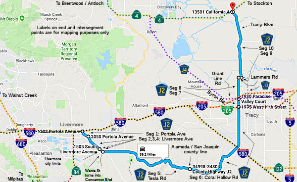 Portola Avenue from I-580 to the Livermore city limits (FAU, 0.72 mi) [Alameda County]
Livermore Avenue in Livermore (FAU, 1.25 mi) [Alameda County]
S Livermore Avnue from the Livermore city limits to Wente Street
Concannon Blvd (FAU, 0.75 mi) [Alameda County]
S Livermore Avenue from Wente Street Concannon Blvd
to Tesla Road (FAS, 0.54 mi) [Alameda County]
Tesla Road from S Livermore Avenue to the San Joaquin county line (FAS, 12.21 mi) [Alameda County]
Corral Hollow Road from the Alameda county line to Byron Road (FAS, 12.05 mi) [San Joaquin County]
Corral Hollow Road from Byron Road to Grant Line Road (County Sign Route J4) (FAU, 0.85 mi) [San Joaquin County]
Corral Hollow Road from Grant Line Road (County Sign Route J4) to Lammers Road (FAS, 2.65 mi) [San Joaquin County]
Lammers Road from Corral Hollow Road to Tracy Blvd (FAS, 0.30 mi) [San Joaquin County]
Tracy Blvd from Lammers Road to Route 4 (FAS, 7.90 mi) [San Joaquin County]
 History and Signage Information
This route was defined in 1960.
According to Tom Fearer, the route over Corral Hollow Pass presently
occupied by County Sign Route J2 is one of the oldest in California as it was a segment
of Spanish El Camino Viejo. El Camino Viejo utilized Corral Hollow Canyon
and Corral Hollow Pass to cross the Diablo Range. Unlike much of the rest
of El Camino Viejo the route over Corral Hollow Pass stayed in use during
the American period in California history. Corral Hollow Canyon was the
site of of coal mining ghost town of known as Tesla and a company town
known as Carnegie was located to the east. The Alameda and San Joaquin
Railroad was routed from Tesla east to Carbona until floods in 1911 wiped
out pretty much everything on Corral Hollow Creek. Despite the corridor
over Corral Hollow Pass having a length history there is large much
indication today of what used to be present. Nonetheless the 1,600 foot
Corral Hollow Pass is a highly scenic alternate to I-580 over New Altamont
Pass.
(Source: Gribblenation Blog (Tom Fearer): Signed County J2 over Corral Hollow Pass; ghost towns, ghost rails and The Old Road (El Camino Viejo))
 National Trails
 This route is part of the De Anza National Historic Trail.
 Other WWW Links
 Status
Total mileage: 39.22 mi.
© 1996-2020 Daniel P. Faigin.
Maintained by: Daniel P. Faigin
<webmaster@cahighways.org>.
 CR J1
CR J1 CR J3
CR J3