
 California Highways:
[Click here for a key to the symbols used. Some county routes were constructed with federal funds. These routes are indicated as FAP (Federal Aid Primary), FAU (Federal Aid Urban), or FAS (Federal Aid Secondary). If no funding source is shown, no federal funds were used. Note that while some segments seem to have the same attributes, they may differ in the county-local road number assigned to the segment, or in the Caltrans Map Sheet number.]
 Routing
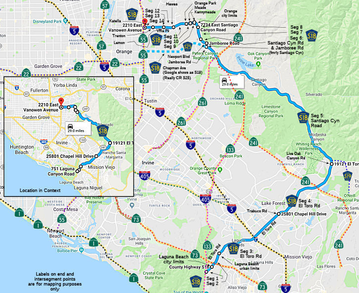 El Toro Road in Laguna Beach from Route 133 to the Laguna Beach city limits (1.30 mi)
El Toro Road from the Laguna Beach city limits to the Laguna Beach urban limits (1.00 mi)
El Toro Road from the Laguna Beach urban limits to Trabuco Road (FAU, 3.50 mi)
El Toro Road from Trabuco Road to Live Oak Canyon Road (FAS, 5.86 mi)
Santiago Canyon Road from Live Oak Canyon Road to Jamboree Road (FAS, 11.50 mi)
Jamboree Road (formerly Santiago Canyon Road) from Jamboree Road to Irvine Park, and then as Santiago Canyon Road to Newport Blvd (FAU, 1.39 mi)
Santiago Canyon Road in Orange from Newport Blvd to the Orange city limits (FAU, 0.81 mi)
Santiago Canyon Road from the Orange city limits to Kennymead Street (FAU, 0.35 mi)
Santiago Canyon Road in Orange from Kennymead Street to Meads Avenue (FAU, 0.34 mi)
Santiago Canyon Road from Meads Avenue to Orange Park Blvd (FAU, 0.27 mi)
Santiago Canyon Road in Orange from Orange Park Blvd to Hewes Street (FAU, 0.78 mi)
Villa Park Road from Hewes to Lemon Street (FAU, 0.65 mi)
Villa Park Road in Villa Park from Lemon Street to Trenton Ave
Wando Road (FAU, 0.75 mi)
Katella Avenue in Orange from Trenton Ave Wanda Road
to Route 55 (FAU, 0.55 mi)
 History and Signage Information
This route was defined in 1970.
 Status
Note: Google Maps shows S18 on Chapman Ave between Santiago Canyon and Route 55. It is really County Sign Route S25.
Total mileage: 29.05 mi.
© 1996-2020 Daniel P. Faigin.
Maintained by: Daniel P. Faigin
<webmaster@cahighways.org>.
 CR S17
 CR S19