
 California Highways:
[Click here for a key to the symbols used. Some county routes were constructed with federal funds. These routes are indicated as FAP (Federal Aid Primary), FAU (Federal Aid Urban), or FAS (Federal Aid Secondary). If no funding source is shown, no federal funds were used. Note that while some segments seem to have the same attributes, they may differ in the county-local road number assigned to the segment, or in the Caltrans Map Sheet number.]
 Routing
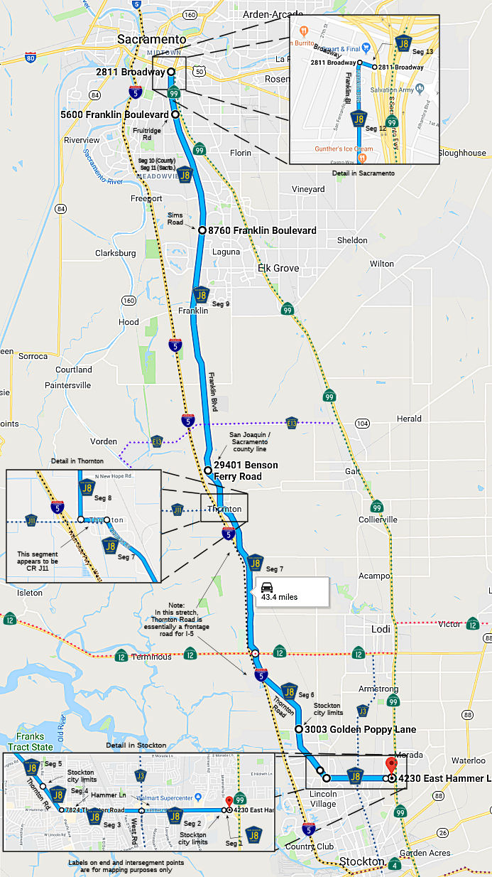 Hammer Lane from Route 99 to the Stockton city limits (FAS, 1.22 mi) [San Joaquin
County]
Hammer Lane from Route 99 to the Stockton city limits (FAS, 1.22 mi) [San Joaquin
County]
Hammer Lane in Stockton from the Stockton city limits to West Lane (FAS, 0.90 mi) [San Joaquin County]
Hammer Lane in Stockton from West Lane to Thornton Road (FAU, 1.65 mi) [San Joaquin County]
Thornton Road from Hammer Lane to the Stockton city limits (FAU, 1.20 mi) [San Joaquin County]
Thornton Road in Stockton from Wagner Heights to the Stockton city limits (FAS, 0.74 mi) [San Joaquin County]
Thornton Road from the Stockton city limits to Route 12 (FAS, 6.30 mi) [San Joaquin County]
Thornton Road from Route 12 to Walnut Grove Road (8.50 mi) [San Joaquin County]
Thornton Road from Walnut Grove Road to the Sacramento county line (FAS, 1.86 mi) [San Joaquin County]
Franklin Blvd from the San Joaquin county line to the Sacramento urban limits at Sims Road (FAS, 13.14 mi) [Sacramento County]
Franklin Blvd (county maintenance) from Sims Road to Fruitridge Road (FAU, 2.59 mi) [Sacramento County]
Franklin Blvd in Sacramento (Sacramento maintenance) from Sims Road to Fruitridge Road (FAU, 3.41 mi) [Sacramento County]
Franklin Blvd in Sacramento from Fruitridge Road to Broadway ( 2.20 mi) [Sacramento County]
Broadway in Sacramento from Franklin Blvd to Route 99 (0.10 mi) [Sacramento County]
 History and Signage Information
This route was defined in 1960.
 Status
Total mileage: 43.81 mi.
In April 2026, it was reported that the Franklin Bridge over Lost Slough
reopened on April 10, 2026, coinciding with the closure of the New Hope
Road Bridge, which was undergoing its own replacement project. The
86-year-old bridge on Franklin Boulevard was replaced after maintenance
and other necessary repairs forced several temporary closures. According
to the CEQA, the replacement bridge included two 12-ft traffic lanes with
adjacent 6-ft paved shoulders on both sides. The shoulders were upgraded
to provide space for future Class II bike lanes, consistent with the
Sacramento County Bicycle Master Plan. The replacement bridge would have a
total width of 39 ft and will be horizontally aligned along the existing
Franklin Blvd centerline. The total length of the project is expected to
be approximately 2,900 ft, including the 520-ft long replacement bridge
and roadwork (divided almost evenly between the north and south ends of
the bridge) beyond the bridge abutments. The roadwork beyond the bridge
abutments will include reconstructing the bridge approaches and shoulders.
The bridge is located on Franklin Blvd south of Twin Cities Rd. (County Sign Route E13),
in the segment along Franklin Blvd from the San Joaquin county line to the
Sacramento urban limits at Sims Road.
(Source: Fox 40 Sacramento, 4/1/2026; CEQA, "Franklin Boulevard over Lost Slough Bridge Replacement", SCH №
2016052014, 5/5/2016)
© 1996-2024 Daniel P. Faigin.
Maintained by: Daniel P. Faigin
<webmaster@cahighways.org>.
 CR J7
CR J7 CR J9
CR J9