
 California Highways:
[Click here for a key to the symbols used. Some county routes were constructed with federal funds. These routes are indicated as FAP (Federal Aid Primary), FAU (Federal Aid Urban), or FAS (Federal Aid Secondary). If no funding source is shown, no federal funds were used. Note that while some segments seem to have the same attributes, they may differ in the county-local road number assigned to the segment, or in the Caltrans Map Sheet number.]
 Routing
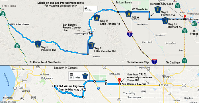 Panoche Road from Route 25
 and to Little Panoche Road (FAS,
28.94 mi) [San Benito County]
Little Panoche Road from Panoche Road to the Fresno county line (FAS, 6.36 mi) [San Benito County]
Little Panoche Road from the San Benito county line to W. Shields Avenue at I-5 (FAS, 14.21 mi) [Fresno County]
W, Shields Avenue from Little Panoche Road at I-5 to Fairfax Avenue (FAS, 8.96 mi) [Fresno County]
Fairfax Avenue from W. Shields Avenue to Belmont Avenue (FAS, 2.00 mi) [Fresno County]
Belmont Avenue from Fairfax Avenue to the Mendota city limits (FAS, 9.90 mi) [Fresno County]
Belmont Avenue in Mendota from the Mendota city limits to Route 33 (FAS, 0.11 mi) [Fresno County]
 History and Signage Information
This route was defined in 1958.
Panoche Pass was a well-established crossing of the Diablo Range prior to
European contact. Panoche Road became to come into prominence as the
primary highway over the Diablo Range in 1854, following founding of the
New Idria Mercury Mine. The corridor over Panoche Pass would remain
the favored route over the Diablo Range to San Joaquin Valley until the
Pacheco Pass Highway was rebuilt to state highway standards in 1923.
Panoche Road was designated as part of Sign Route 180 in August 1934 when
the initial run of Sign State Route was announced. Despite obtaining
a Sign Route designation, the corridor of Panoche Road was never adopted
as State Highway and was only partially modernized during the 1940s.
In 1958, County Sign Route J1 was designated over Panoche Road between Sign Route 25 and
Little Panoche Road. In 1959, LRN 263 was added to the State Highway
System as a planned corridor following the established path of Panoche
Road. Despite being annexed into the legislative definition of Route 180 in 1964, the corridor Panoche Road has never been added to the State
Highway System. Panoche Road begins at Route 25 near Paicines in San
Benito County, and carries the designation of County Sign Route J1 through the Diablo
Range to Little Panoche Road in Panoche Valley. Panoche Road
continues east from Panoche Valley and becomes a dirt highway approaching
the ford of Big Panoche Creek. The dirt segment of this corridor
continues into Fresno County passing through the Panoche Hills and Tumey
Hills before emerging into San Joaquin Valley at an interchange with
I-5. The remaining 18 miles of Panoche Road east of I-5 to Route 180
near Mendota are comprised of conventional paved highway.
(Source: Gribblenation Blog (Tom Fearer), "Panoche Road and former California State Route 180 over the Diablo Range", 12/25/2025)
 Status
Total mileage: 70.48 mi.
According to Tom Fearer (Max Rockatansky) on AAroads in December 2016, Route J1 is deceptive. This route looks pretty good from
Fresno County west from I-5 for a couple miles and east from Route 25 in
San Benito County but really isn't. This is the second longest signed
county route in California at 70 miles only behind County Sign Route J16. County Sign Route J1 basically
is falling apart and is in terrible shape, you're in for a hell of a drive
if you come this way. County Sign Route J1 gets pretty nasty eastwards after the first
one-lane bridge about a half dozen miles from Route 25. Panoche Pass
Summit is only 2,250 feet above sea level but the road is in terrible
shape getting there. The advertised limit is 55 MPH but 35-45 MPH is
really all you ought to be going for in the straights. The pavement is bad
enough shape that 20-25 MPH is often necessary in sharp turns. If you're a
one-lane bridge fan this is your road.
(Source: Tom Fearer (Max Rockatansky) on AARoads, 12/14/2016)
He also noted: J1 is closely signed to the original proposed alignment of
Route 180 west of Mendotta to Route 25. Back in 1938 several maps show
Route 180 actually on an alignment to Route 25 via Panoche Road. It would
seem that many routes like US 101 in San Francisco, CA 33 in Fresno
County, and even parts of Route 49 were actually signed on County/City
maintained roadways.
(Source: Gribblenation Blog: County Route J1 11/2017)
 Other WWW Links
© 1996-2024 Daniel P. Faigin.
Maintained by: Daniel P. Faigin
<webmaster@cahighways.org>.
 CR G21
 CR J2
CR J2