
 California Highways:
[Click here for a key to the symbols used. Some county routes were constructed with federal funds. These routes are indicated as FAP (Federal Aid Primary), FAU (Federal Aid Urban), or FAS (Federal Aid Secondary). If no funding source is shown, no federal funds were used. Note that while some segments seem to have the same attributes, they may differ in the county-local road number assigned to the segment, or in the Caltrans Map Sheet number.]
 Routing
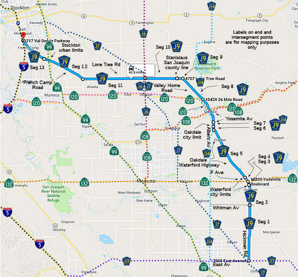 Hickman Road from East Avenue (County Sign Route J17) to Whitmore Avenue (7.07 mi) [Stanislaus
County]
Hickman Road from East Avenue (County Sign Route J17) to Whitmore Avenue (7.07 mi) [Stanislaus
County]
Hickman Road from Whitmore Avenue to the Waterford city limits (FAS, 2.90 mi) [Stanislaus County]
Hickman Road in Waterford from the Waterford city limits to Route 132 (FAS, 0.16 mi) [Stanislaus County]
F Street in Waterford from Route 132 to the Waterford city limits (FAS, 0.89 mi) [Stanislaus County]
Oakdale Waterford Highway from the Waterford city limits to Albers Road (FAS, 7.41 mi) [Stanislaus County]
Alberts Road from Oakdale Waterford Highway to the Oakdale city limits (FAS, 0.81 mi) [Stanislaus County]
The segment from Albers Road and Oakdale Waterford Highway and Route 120 is cosigned with County Sign Route J14.
Alberts Road in Oakdale from the Oakdale city limits to Yosemite Avenue (0.57 mi) [Stanislaus County]
The segment from Albers Road and Oakdale Waterford Highway and Route 120 is cosigned with County Sign Route J14.
Yosemite Avenue in Oakdale from Alberts Road to Route 120 (0.76 mi) [Stanislaus County]. This is the junction of Route 108 and Route 120.
The segment from Albers Road and Oakdale Waterford Highway and Route 120 is cosigned with County Sign Route J14.
Note that there is a route break here along Route 120 from Route 108 to Valley Home Road
Valley Home Road from Route 120 to Lone Tree Road (FAS, 3.65 mi) [Stanislaus County]
Lone Tree Road from Valley Home Road to the San Joaquin county line (FAS, 0.74 mi) [Stanislaus County]
Lone Tree Road from the Stanislaus county line to Escalon Belotta Road (FAS, 4.13 mi)
Lone Tree Road from Escalone Belotta Road to French Camp Road (FAS, 8.00 mi)
French Camp Road from Lone Tree Road to the Stockton urban limits (FAS, 7.45 mi)
 French Camp Road from the Stockton urban limits to I-5 (FAU, 1.65
mi)
French Camp Road from the Stockton urban limits to I-5 (FAU, 1.65
mi)
 History and Signage Information
This route was defined in 1960.
Per Tom Fearer, the original alignment of US 99 ran from the Route 99
Freeway west Frontage Road westward on County Sign Route J9/French Camp Road to El Dorado
Street in French Camp. Originally US 99 had an elongated alignment south
of Stockton. US 99 southbound entered Stockton on Wilson Way where turned
west on Charter Way and south on McKinley Avenue. US 99 continued south to
French Camp via El Dorado Road and onto French Camp Road where it met US 48 at Harlan Road. US 99 continued southeast on French Camp Road to Main
Street in Manteca. This alignment appears to have been in use until 1929.
Likely starting in 1929, US 99 split into US 99E at Mariposa Road/LRN 4
and US 99W at Charter Way/LRN 5. US 99E largely followed the current Route 99 freeway south to Manteca. US 99W followed McKinley Avenue, El Dorado
Street and French Camp Road south to French Camp. From French Camp, US 99W
continued south to Lanthrop on Harlan Road and Manthey Road where it met
the new terminus with US 48. At Yosemite Avenue/LRN 66, the route of US 99W turned eastward towards US 99E in Manteca.
(Source: Gribblenation Blog The original US Route 99 alignment on Signed County Route J9/French Camp Road)
 Other WWW Links
 Status
Total mileage: 44.05 mi.
© 1996-2020 Daniel P. Faigin.
Maintained by: Daniel P. Faigin
<webmaster@cahighways.org>.
 CR J8
CR J8 CR J10