
 California Highways:
[Click here for a key to the symbols used. Some county routes were constructed with federal funds. These routes are indicated as FAP (Federal Aid Primary), FAU (Federal Aid Urban), or FAS (Federal Aid Secondary). If no funding source is shown, no federal funds were used. Note that while some segments seem to have the same attributes, they may differ in the county-local road number assigned to the segment, or in the Caltrans Map Sheet number.]
 Routing
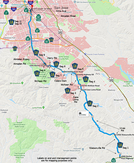 Watsonville Road from Route 152 in Gilroy to Uvas Road (FAS, 3.62 mi)
Uvas Road from Watsonville Road to Casa Loma Road (9.76 mi)
Mc Kean Road from Casa Loma Road to the San Jose city limits (0.72 mi)
Mc Kean Road in San Jose from the San Jose city limits to Bailey Avenue (1.67 mi)
Mc Kean Road in San Jose from Bailey Avenue to Calero Dam (FAS, 1.18 mi)
Mc Kean Road from Calero Dam to Harry Road (FAS, 3.00 mi)
Mc Kean Road in San Jose from Harry Road to Almaden Road (FAS, 0.37 mi)
Almaden Road from Mc Kean Road to Barnes Lane (FAU, 0.25 mi)
Almaden Road in San Jose from Barnes Lane to Almaden Expressway (FAU, 0.35 mi)
Almaden Expressway in San Jose (FAU, 7.97 mi)
 Status
In September 2011, work began to widen Almaden Expressway from Blossom Hill Road to Branham Lane. The project will add numerous turn lanes and upgrade traffic lights. For most of this stretch, there will be an extra through lane in each direction. A fifth turn lane will be added on Almaden Plaza Way. A third left-turn lane and a right-turn-only lane will be put in at Blossom Hill to north Almaden. And a new fourth northbound lane on the expressway will help provide drivers headed to south and north 85 with separate lanes instead of one shared lane. Signals will be retimed based on traffic conditions throughout the day, not just during commute periods. The speed limit will also be increased to 50 mph.
Almaden Road in San Jose from Almaden Expressway to Alma Street (FAU, 0.19 mi)
Alma Ave from Almaden Road to (Former) Route 82 (Monterey St/First St) (FAU, 0.30 mi)
 History and Signage Information
This route was defined in 1962. Alamaden Expressway construction, between Alma and Canoas Garden, began in 1959. Construction was completed in 1984.
The present corridor of County Sign Route G8 began to take shape with the
emergence of the Almaden Expressway. According to the October 1960
California Highways & Public Works, Unit 1 of the Almaden Expressway
opened in November of 1959 between Alma Avenue near downtown San Jose
south to the Guadalupe River as part of a Federal Highway Aid Secondary
program. Unit 2 of the Almaden Expressway was being constructed over
existing Almaden Road to the then new Hillsdale Expressway. The corridor
of Almaden Road had been in use as a trail by the Native Ohlone tribes who
used it to obtain Cinnabar from Mine Hill of the Santa Cruz Mountains for
use as red paint dye. In 1845 Mexican Army Captain and trained geologist
Andreas Castillero proved that the red rocks at Mine Hill contained
Quicksilver (Mercury). The New Almaden Mine spiked in importance due
to the onset of the California Gold Rush after the finding Gold at
Sutter's Mill was announced. Mercury was an essential product used
in the assay process for much of the mines of the California Gold Rush
period and would ultimately see the New Almaden Mine become the largest
producer in the world. By the 1950s suburban sprawl out of the core of San
Jose began to consume the established core of Almaden Road. This
culminated in the planning of the Almaden Expressway which was largely
plotted out by 1957. Santa Clara County purchased the New Almaden Mine in
1976 and converted it into Almaden Quicksilver County Park by 1978.
The Alamaden Expressway reached its current terminus at Harry Road by
1984.
(Source: Gribblenation Blog (Tom Fearer), “Santa Clara County Route G8 and the New Almaden Quicksilver Mine”, February 2021)
StatusThe SAFETEA-LU act, enacted in August 2005 as the reauthorization of TEA-21, provided the following expenditures on or near this route:
High Priority Project #1297: Almaden Expressway (Santa Clara County Sign Route G8) improvements between Branham Lane and Blossom Road, San Jose. $2,800,000.
Total mileage: 29.38 mi.
 Other WWW Links
© 1996-2020 Daniel P. Faigin.
Maintained by: Daniel P. Faigin
<webmaster@cahighways.org>.
 CR G7
CR G7 CR G9
CR G9