
 California Highways:
[Click here for a key to the symbols used. Some county routes were constructed with federal funds. These routes are indicated as FAP (Federal Aid Primary), FAU (Federal Aid Urban), or FAS (Federal Aid Secondary). If no funding source is shown, no federal funds were used. Note that while some segments seem to have the same attributes, they may differ in the county-local road number assigned to the segment, or in the Caltrans Map Sheet number.]
 Routing
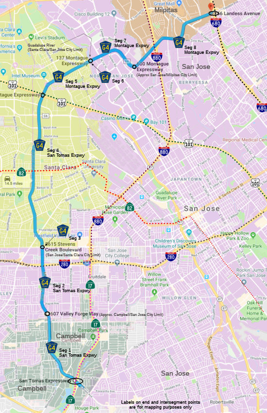 San Tomas Expressway in Campbell from Route 17 to the San Jose city limits
(FAU, 2.22 mi)
San Tomas Expressway in Campbell from Route 17 to the San Jose city limits
(FAU, 2.22 mi)
San Tomas Expressway in San Jose from the San Jose city limits to Stevens Creek Blvd (FAU, 1.83 mi)
San Tomas Expressway from Stevens Creek Blvd to the Santa Clara city limits (FAU, 0.15 mi).
Note: This segment makes no sense, as Stevens Creek Blvd is the Santa Clara city limit. Perhaps there was a post-1976 annexation.
San Tomas Expressway in Santa Clara from the Santa Clara city limits to US 101 (FAU, 4.10 mi)
 Status
In June 2016, it was reported that there are plans to widen the expressway from south of Homestead Road to El Camino Real. Plans include:
The carpool lane may be temporarily closed.
(Source: Mercury News, 6/14/2016)
In September 2019, it was reported that Santa Clara County plans to turn
off the electronic signs and beacons that were installed decades ago to
indicate carpool lane operation, and remove them. The county will rely on
the black-and-white carpool signs already installed that show the carpool
hours. The yellow flashing lights were put in place to provide drivers
extra warning.
(Source: �� Mercury News, 9/16/2019)
Montague Expressway in Santa Clara from US 101 to the Guadalupe River (FAU, 1.62 mi)
Montague Expressway from the Guadalupe River to the San Jose city limits (FAU, 0.76 mi).
Note: This segment makes no sense, as the Guadalupe River is the San Jose city limit. Perhaps there was an annexation of Santa Clara county land post-1976 with either Alviso, Barryesa, or North San Jose.
Montague Expressway in San Jose from the San Jose city limits to the Milpitas city limits (FAU, 2.10 mi)
Montague Expressway in Milpitas from the Milpitas city limits to I-680 (FAU, 1.33 mi)
StatusIt was reported in October 2016 that South Milpitas Boulevard will be
completely closed from Montague to Garden Street for five weeks beginning
Oct. 14, 2016 for a big water project that will also widen and raise
Montague to accommodate the flood control measures and fill the carpool
lane gap.
(Source: SJ Mercury News, 10/3/2016)
 Other WWW Links
 History and Signage Information
The San Tomas Expressway portions were defined in 1962. The Montague Expressway portions were defined in 1978. Apparently, County Sign Route G4 continued along Hillsdale Avenue, and Capitol Expressway in San Jose. Capitol Expressway is now County Sign Route G21.
 Naming
Expressways were most often named for the older roads they were built over, such as Almaden, Capitol, Lawrence,
Oregon, Page Mill and Montague. As the expressways expanded they kept
their name. For Montague Expressway in Santa Clara and proceeding through
San Jose to Milpitas, the alignments used were Montague Road, Trimble Road
and Landess Avenue. The big sweeping curves on Montague are the connecting
transitions from one alignment to the other. Montague Road ran from
Lafayette Street to North First Street. There used to be property,
including a large Victorian home, owned by W.W. Montague. The company
still exists under the Montague name and specializes in restaurant-quality
stoves and ranges. Apparently Montague lived on the south side of the road
and the Lick Mansion is on the north off Lick Mill Boulevard. Though they
looked somewhat alike, do not confuse them. The Montague residence no
longer exists. W.W. Montague was a rancher and a San Francisco postmaster
who also manufactured coal and wood-burning stoves.
(Source: SJ Mercury News 3/10/2015; City of Santa Clara)
StatusThe San Tomas Expressway portions are signed. Montague Expressway is unsigned. Total mileage for both expressways: 14.11 mi.
The SAFETEA-LU act, enacted in August 2005 as the reauthorization of TEA-21, provided the following expenditures on or near this route:
 Commuter Lanes
© 1996-2020 Daniel P. Faigin.
Maintained by: Daniel P. Faigin
<webmaster@cahighways.org>.
 CR G3
CR G3 CR G5
CR G5