
 California Highways:
[Click here for a key to the symbols used. Some county routes were constructed with federal funds. These routes are indicated as FAP (Federal Aid Primary), FAU (Federal Aid Urban), or FAS (Federal Aid Secondary). If no funding source is shown, no federal funds were used. Note that while some segments seem to have the same attributes, they may differ in the county-local road number assigned to the segment, or in the Caltrans Map Sheet number.]
 Routing
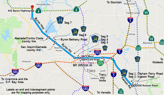 Durham Ferry Road from Airport Way (County Sign Route J3) to Kasson Road (FAS, 0.20 mi) [San Joaquin
County]
Durham Ferry Road from Airport Way (County Sign Route J3) to Kasson Road (FAS, 0.20 mi) [San Joaquin
County]
Kasson Road from Durham Ferry Road to Eleventh Street (7.25 mi) [San Joaquin County]
Grant Line Road from Eleventh Street to the Tracy city limits (FAS, 3.09 mi) [San Joaquin County]
 National Trails
 This segment, from Eleventh Street to G Street in Banta was part of the Lincoln Trail.
Grant Line Road in Tracy (FAU, 1.75 mi) [San Joaquin County]
Grant Line Road from the Tracy city limits to Byron Highway (FAS, 2.47 mi) [San Joaquin County]
 Byron Road
 Highway from Grant Line Road to the Alameda county line (FAS, 5.00 mi) [San Joaquin County]
Byron Bethany Road from the San Joaquin county line to the Contra Costa county line (FAS, 1.41 mi) [Alameda County]
Byron Highway from the Alameda county line to Route 4 (FAS, 6.82 mi) [Contra Costa County]
 Status
According to reports, this segment may have been decommissioned, as the signs have been removed (02/2000). However, as of 2005, the Contra Costa County installed brand new signs along Byron Highway, marking it as J4. See the page on Route 239 for some proposed improvements on this route, as portiongs of County Sign Route J4 parallel unconstructed Route 239.
 History and Signage Information
This route was defined in 1960.
National Trails This route is part of the De Anza National Historic Trail.
 Other WWW Links Status
Total mileage: 27.99 mi.
© 1996-2020 Daniel P. Faigin.
Maintained by: Daniel P. Faigin
<webmaster@cahighways.org>.
 CR J3
CR J3 CR J5
CR J5