
 California Highways:
[Click here for a key to the symbols used. Some county routes were constructed with federal funds. These routes are indicated as FAP (Federal Aid Primary), FAU (Federal Aid Urban), or FAS (Federal Aid Secondary). If no funding source is shown, no federal funds were used. Note that while some segments seem to have the same attributes, they may differ in the county-local road number assigned to the segment, or in the Caltrans Map Sheet number.]
 Routing
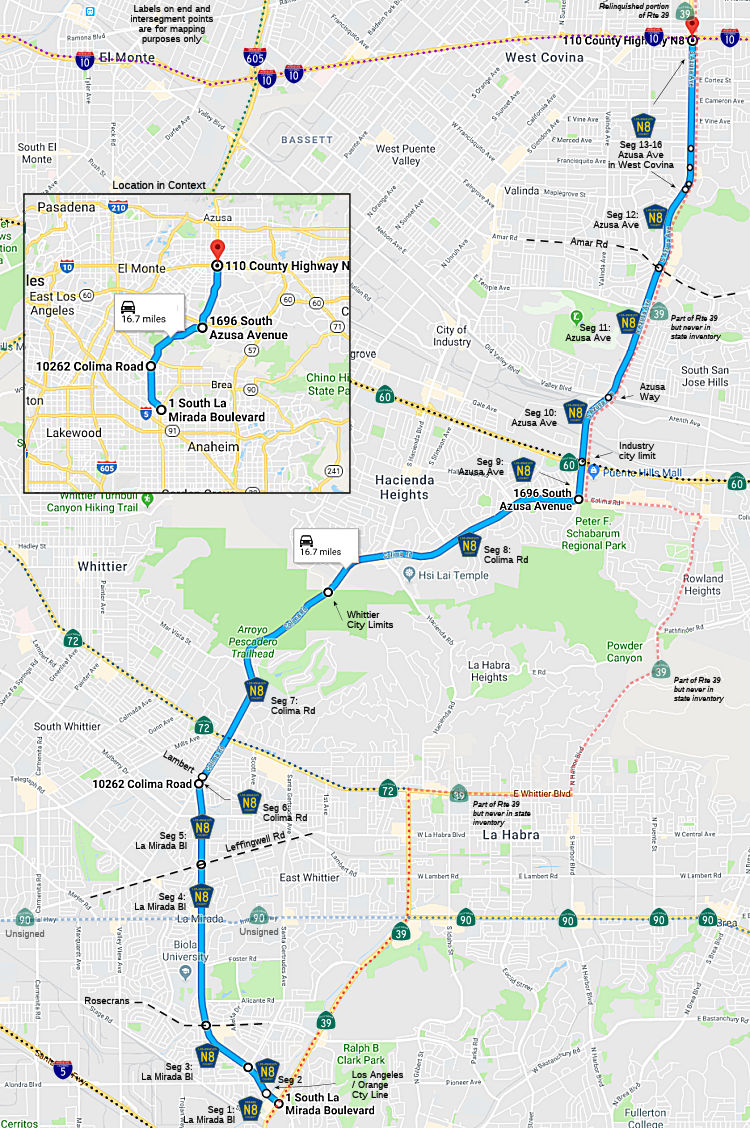 La Mirada Blvd in Buena Park from Route 39 to the Los Angeles county line (0.35 mi)
[Orange County]
La Mirada Blvd in Buena Park from Route 39 to the Los Angeles county line (0.35 mi)
[Orange County]
La Mirada Blvd in La Mirada from the Orange county line to Santa Gertrudes Ave (0.24 mi) [Los Angeles County]
La Mirada Blvd in La Mirada from Santa Gertrudes Ave to Rosecrans Avenue (FAU, 0.80 mi) [Los Angeles County]
La Mirada Blvd in La Mirada from Rosecrans Avenue to Leffingwell Road (1.97 mi) [Los Angeles County]
La Mirada Blvd from Leffingwell Road to Colima Road (FAU, 0.99 mi) [Los Angeles County]
Colima Road from La Mirada Blvd to Lambert Road (FAU, 0.10 mi) [Los Angeles County]
Colima Road in Whitter from Lambert Road to the Whittier city limits (FAU, 1.74 mi) [Los Angeles County]
Colima Road from the Whitter city limits to Azusa Avenue (FAU, 4.60 mi) [Los Angeles County]
Azusa Avenue from Colima Road to the Industry city limits (FAU, 0.48 mi) [Los Angeles County]
Azusa Avenue in Industry from the Industry city limits to Azusa Way (FAU, 1.13 mi) [Los Angeles County]
Azusa Avenue from Azusa Way to Amar Road (FAU, 1.35 mi) [Los Angeles County]
Azusa Avenue in West Covina from Amar Road to the West Covina city limits (FAU, 0.93 mi) [Los Angeles County]
Azusa Avenue from the West Covina city limits to the West Covina city limits (FAU, 0.10 mi) [Los Angeles County]
Azusa Avenue in West Covina from the West Covina city limits to the West Covina city limits (FAU, 0.30 mi) [Los Angeles County]
Azusa Avenue from the West Covina city limits to the West Covina city limits (FAU, 0.18 mi) [Los Angeles County]
Azusa Avenue in West Covina from the West Covina city limits to I-10 [Los Angeles County]
 History and Signage Information
The City of Industry has a two pages that describes the origins of FAS Rte 1274, which appears to be today's Route 39 and County Sign Route N8. This was to be a route from Huntington Beach and north across the San Gabriel Mountains to the Antelope Valley. The project involved the extension of Azusa Avenue through West Covina to link with Pass and Covina Road just S of Amar Road in La Puente. Part of this effort involved remaking Grazide Road into a four-lane divided highway from Hacienda Bl east for ½ mi.
This route was defined in 1970.
 Status
Total mileage: 16.76 mi.
© 1996-2020 Daniel P. Faigin.
Maintained by: Daniel P. Faigin
<webmaster@cahighways.org>.
 CR N7
CR N7 CR N9
CR N9