
 California Highways:
[Click here for a key to the symbols used. Some county routes were constructed with federal funds. These routes are indicated as FAP (Federal Aid Primary), FAU (Federal Aid Urban), or FAS (Federal Aid Secondary). If no funding source is shown, no federal funds were used. Note that while some segments seem to have the same attributes, they may differ in the county-local road number assigned to the segment, or in the Caltrans Map Sheet number.]
 Routing
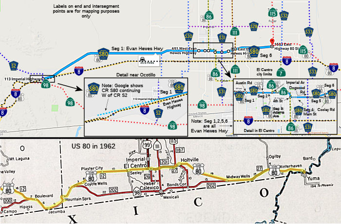 Evan Hewes Highway from Imperial Highway (County Sign Route S2) to Austin Road (FAS, 24.42 mi)
Evan Hewes Highway from Austin Road to the El Centro city limits (FAU, 1.20 mi)
Adams Avenue in El Centro from the El Centro city limits to Imperial Avenue (Route 86) (FAU, 0.27 mi)
Main Street in El Centro from 4th Street (Route 86) to Dogwood Road (County Sign Route S31) (FAU, 0.98 mi)
Evan Hewes Highway from Dogwood Road (County Sign Route S31) to Cooley Road (FAU, 1.03 mi)
Evan Hewes Highway from Cooley Road to Route 115 (FAS, 6.56 mi)
 History and Signage Information
 This is a former routing of US 80. This route was defined in 1973.
 Historical Route
 ACR 123 (Resolution Chapter 104, 8/16/2006) designated segments of former U.S. Highway Route 80 in San Diego and Imperial Counties as Historic
U.S. Highway Route 80, and requested the Department of
Transportation to design and facilitate the posting of appropriate signs
and take related actions in that regard. The resolution noted that US 80,
largely parallel to current I-8, was a 180-mile highway spanning San Diego
and Imperial Counties from San Diego Bay to the Colorado River, and played
a major role in the development of this state during much of the 20th
century. In 1909, California voters approved a statewide bond measure for
road improvement purposes in the amount of $18 million, providing, among
other things, funds to construct a road between San Diego and Imperial
Counties, and their county seats of San Diego and El Centro. In 1915, a
unique wood plank road was built over the Imperial Valley sand hills,
resulting in a shorter route. In 1925, the federal government became
involved in standardized highway route designations across the nation and
even numbers were assigned to major highways running east and west, and
odd numbers for highway running north and south. The numbering of highways
proceeded in numerical order beginning in the north and east and
continuing south and west, respectively, and, as a result, the routing
along California's southern border was formally designated as US 80. This
road, from San Diego to Tybee Island, Georgia, was adopted as US 80 on
November 11, 1926. US 80 was the first ocean-to-ocean transcontinental
highway to be completed, and portions of the route were known as the
Bankhead, Broadway of America, Dixie, Lee, Old Spanish Trail, and Southern
Transcontinental Highway.
 Other WWW Links
 Status
Total mileage: 34.46 mi.
 CR S78
 Return to County Routes
© 1996-2020 Daniel P. Faigin.
Maintained by: Daniel P. Faigin
<webmaster@cahighways.org>.