
 California Highways:
[Click here for a key to the symbols used. Some county routes were constructed with federal funds. These routes are indicated as FAP (Federal Aid Primary), FAU (Federal Aid Urban), or FAS (Federal Aid Secondary). If no funding source is shown, no federal funds were used. Note that while some segments seem to have the same attributes, they may differ in the county-local road number assigned to the segment, or in the Caltrans Map Sheet number.]
 Routing
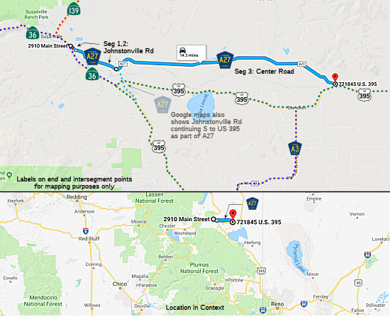 Johnstonville Road from Route 36 in Susanville to the Susanville city limits (FAS, 0.04
mi)
Johnstonville Road from Route 36 in Susanville to the Susanville city limits (FAS, 0.04
mi)
Johnstonville Road from the Susanville city limits to Center Road (FAS, 2.60 mi)
Center Road from Johnstonville Road to US 395 (FAS, 12.38 mi).
Note that Google Maps also shows County Sign Route A27 continuing S along Johnstonville Rd and Johnstonville Dr to US 395. This segment appears not to be part of the County Route system, although it does appear to be a former routing of Route 36.
 History and Signage Information
This route was defined in 1971.
 In July 1964, a relocation of Route 36 in Susanville
occurred. The new highway replaced a winding narrow section (now Segments
1 and 2 of County Sign Route A27) constructed in 1931, which had 13 curves and a minimum
radius of 500'. Two of the curves were signed for 35 mph. During this
work, the existing 2-lane highway was converted to a 64' all paved
section, changing to a 40' all paved section outside of the Susanville
city limits. The portion of the highway constructed will be the westbound
lanes of an ultimate 4 lane freeway. Per CHPW, right of way has been
purchased and fenced for ultimate interchanges at the E city limits of
Susanville and at the junction of Route 36 and US 395.
In July 1964, a relocation of Route 36 in Susanville
occurred. The new highway replaced a winding narrow section (now Segments
1 and 2 of County Sign Route A27) constructed in 1931, which had 13 curves and a minimum
radius of 500'. Two of the curves were signed for 35 mph. During this
work, the existing 2-lane highway was converted to a 64' all paved
section, changing to a 40' all paved section outside of the Susanville
city limits. The portion of the highway constructed will be the westbound
lanes of an ultimate 4 lane freeway. Per CHPW, right of way has been
purchased and fenced for ultimate interchanges at the E city limits of
Susanville and at the junction of Route 36 and US 395.
 Status
Total mileage: 15.02 mi.
© 1996-2020 Daniel P. Faigin.
Maintained by: Daniel P. Faigin
<webmaster@cahighways.org>.
 CR A26
 CR A28