
 California Highways:
[Click here for a key to the symbols used. Some county routes were constructed with federal funds. These routes are indicated as FAP (Federal Aid Primary), FAU (Federal Aid Urban), or FAS (Federal Aid Secondary). If no funding source is shown, no federal funds were used. Note that while some segments seem to have the same attributes, they may differ in the county-local road number assigned to the segment, or in the Caltrans Map Sheet number.]
 Routing
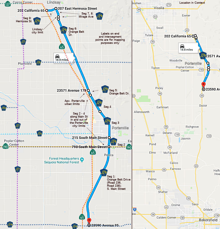 Orange Belt Drive (Road 236, Road 238) and S. Main Street from County Sign Route J24 to Route 190.
Note: This is not in the database definition, but does show on the Thomas Bros. Map and in Google Maps.
Main Steet in Porterville from Route 190 to Orange Avenue (FAS, 0.68 mi)
Main Street in Porterville from Orange Avenue to the Porterville city limits (FAU, 1.45 mi)
Main Street from the Porterville city limits to the Porterville city limits (FAU, 0.85 mi)
Orange Belt Drive in Porterville from the Porterville city limits to the Porterville urban limits (FAU, 0.04 mi)
Orange Belt Drive from the Porterville urban limits to Mirage Avenue (FAS, 7.86 mi)
Mirage Avenue from Orange Belt Drive to the Lindsay city limits (FAU, 0.10 mi)
Mirage Avenue in Lindsay from the Lindsay city limits to Hermosa Street (FAU, 0.65 mi)
Hermosa Street in Lindsay from Mirage Avenue to Route 65 (FAU, 0.82 mi)
 History and Signage Information
This route was defined in 1971. Road 236, Main Street, Orange Belt Drive, Mirage Avenue, and Hermosa Street were part of the original alignment of Route 65, as discussed in the Gribblenation blogs linked below.
 Other WWW Links
 Status
Total mileage: 12.45 mi.
© 1996-2020 Daniel P. Faigin.
Maintained by: Daniel P. Faigin
<webmaster@cahighways.org>.
 CR J28
 CR J30