
Butte
Former County Sign Route B1
[Click here for a key to the symbols used.
Some county routes were constructed with federal funds.
These routes are indicated as FAP (Federal Aid Primary), FAU (Federal Aid Urban), or FAS (Federal Aid Secondary).
If no funding source is shown, no federal funds were used.
Note that while some segments seem to have the same attributes,
they may differ in the county-local road number assigned to the segment,
or in the Caltrans Map Sheet number.]
 Routing
 History and Signage Information
County Sign Route B1 appears to be a county adoption and signage of a portion of former
LRN 30. Based on the 1966 Gousha Map, it appears to approximate the route
of the Route 162 extension, although it is unclear if the signage covered
all of the route in Butte county, or indeed, all of LRN 30 E of Oroville.
The routing that was to be LRN 30 was defined in the 1909 First Bond
Issue as running from Oroville to Quincy. This was likely the
Oroville-Quincy Highway. In the 1919 Third Bond Issue, the route was
abandoned as a state highway and LRN 21 extended to cover the mileage to
Quincy. The original LRN 30 appears to have had the following route:
(Source: Gribblenation Blog "California State Route 162 to the Bidwell Bar Bridge (both the 1965 and 1856 variants)")
- From modern Route 162 Bridge Street east to Oroville-Quincy Highway.
- Oroville-Quincy Highway back to modern Route 162.
- Route 162 to Heritage Road.
- Heritage Road into Lake Oroville via Bidwell Canyon.
- A now sunken portion of what was LRN 30 beneath Lake Oroville to the
Middle Fork Feather River. LRN 30 would have crossed the Middle Fork
Feather River via the 1855 Bidwell's Bar Bridge.
- LRN 30 would have emerged from Lake Oroville via what is now Foreman
Creek Road.
- Foreman Creek Road to the modern terminus of Route 162.
- From the modern terminus of Route 162 the route of LRN 30 continued
east on Oroville-Quincy Road on Plumas National Forest Route 119 to
Quincy.
Acronyms and Explanations:
- "LRN" refers to the Pre-1964 Legislative Route Number.
"US" refers to a US Shield signed route.
"I" refers to an Eisenhower Interstate signed route.
"Route" usually indicates a state shield signed route, but said route may be signed as US or I.
- Previous Federal Aid (pre-1992) categories:
Federal Aid Interstate (FAI); Federal Aid Primary (FAP);
Federal Aid Urban (FAU); and Federal Aid Secondary (FAS).
Current Functional Classifications (used for aid purposes):
Principal Arterial (PA); Minor Arterial (MA);
Collector (Col); Rural Minor Collector/Local Road (RMC/LR). Note that ISTEA repealed the previous Federal-Aid System, effective in 1992, and established the functional classification system for all public roads.
- Other frequently used terms: California Transportation Commission (Commission or CTC), California Department of Transportation (Department or Caltrans), Regional Improvement Program (RIP), Interregional Improvement Program (IIP), State Transportation Improvement Program (STIP), State Highway Operation and Protection Program (SHOPP), Traffic Congestion Relief Program (TCRP), Clean Air and Transportation Improvement Act of 1990 (Proposition 116), High Speed Passenger Train Bond Program (Proposition 1A), Highway Safety, Traffic Reduction, Air Quality, and Port Security Bond Act of 2006 (Proposition 1B), Corridor Mobility Improvement Account (CMIA), State Route 99 Bond Program (RTE or SR 99), Local Bridge Seismic Retrofit Account (LBSRA), Trade Corridors Improvement Fund (TCIF), Highway-Railroad Crossing Safety Account (HRCSA), State-Local Partnership Program (SLPP), Environmental Phase (PA&ED), Design Phase (PS&E), Right of Way (R/W), Fiscal Year (FY), Active Transportation Program (ATP), Trade Corridor Enhancement Program (TCEP), Local Partnership Program (LPP), Local Streets and Roads Program (LSRP), Solutions for Congested Corridors Program (SCCP).
 CR A29
 CR B2
CR B2
© 1996-2020 Daniel P. Faigin.
Maintained by: Daniel P. Faigin
<webmaster@cahighways.org>.

 California Highways:
 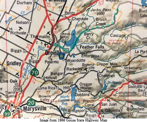 From Route 70
near Oroville to Foreman Creek Road via the Bidwell Bar Bridge. The
terminus of the route is estimated.
From Route 70
near Oroville to Foreman Creek Road via the Bidwell Bar Bridge. The
terminus of the route is estimated.