
 California Highways:
[Click here for a key to the symbols used. Some county routes were constructed with federal funds. These routes are indicated as FAP (Federal Aid Primary), FAU (Federal Aid Urban), or FAS (Federal Aid Secondary). If no funding source is shown, no federal funds were used. Note that while some segments seem to have the same attributes, they may differ in the county-local road number assigned to the segment, or in the Caltrans Map Sheet number.]
 Routing
 Naming
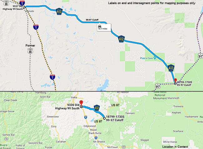
"Veteran's Memorial Highway". On Nov. 1, 2011 the board of supervisors of Siskiyou passed a motion to designate County Sign Route A12 as Veterans Memorial Highway to honor the service of Siskiyou County veterans. Siskiyou County Veterans Services Officer Tim Grenvik brought the proposal to the board with the support of the county roads department and the sheriff’s office. Signs have been placed at either end of County Sign Route A12, one just east of the railroad tracks in Grenada at the site of Friday’s ceremony, and one just west of the road’s intersection with Route 97.
 Other WWW Links
 History and Signage Information
This route was formally defined in 1959.
In the Gribblenation Blog "Siskiyou County Route A12; 99-97 Cutoff", Tom Fearer provides a detailed history of the route. The following is summarized from that blog:
(Source: Gribblenation Blog (Tom Feaerer), "Siskiyou County Route A12; 99-97 Cutoff", December 2020)
A12 consists of what was the road east of former US 99 connecting Grenada to the community of Mayten. A road east of Mayten to US 97 existed before 99-97 Cutoff but was primitive compared to the modern A12. The construction of 99-97 Cutoff circa 1955 was a Federal Aid Secondary ("FAS") project that helped Siskiyou County fund construction of a modern highway.
The corridor of 99-97 Cutoff is described as being explored by Hudson Bay Company trappers in 1833. By 1855, the future corridor of 99-97 Cutoff was first used by a wagon train as en route to Yreka. The corridor of future 99-97 Cutoff was popular with settlers due to the presence of the easy to identify Sheep Rock. In 1856, the future corridor of 99-97 Cutoff began to be traveled by Stage Lines and appears to have been an early example of a Franchise Toll Road. By 1857, the future corridor of 99-97 Cutoff came to be known as the "Pit River Road" but in time would be more commonly known as the "Shasta Valley Route." The Shasta Valley Route remained an unsurfaced highway until Siskiyou County undertook efforts to pave it in the 1940s. A realignment effort of the Shasta Valley Route began in 1947 and eventually became the FAS project known as 99-97 Cutoff.
© 1996-2020 Daniel P. Faigin.
Maintained by: Daniel P. Faigin
<webmaster@cahighways.org>.
 99-97 Cutoff between I-
 CR A11
 CR A13