
 California Highways:
[Click here for a key to the symbols used. Some county routes were constructed with federal funds. These routes are indicated as FAP (Federal Aid Primary), FAU (Federal Aid Urban), or FAS (Federal Aid Secondary). If no funding source is shown, no federal funds were used. Note that while some segments seem to have the same attributes, they may differ in the county-local road number assigned to the segment, or in the Caltrans Map Sheet number.]
 Routing
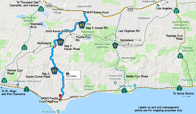 Kanan Dume Road from Route 1 to Mulholland Highway (FAU, 6.54 mi)
Kanan Road from Mulholland Highway to Triunfo Canyon Road (FAS, 2.80 mi)
Kanan Road from Triunfo Canyon Road to US 101 (FAS, 3.20 mi)
 History and Signage Information
This route was defined in 1974.
The original Kanan Road was named after the Waring family, which settled
Agoura in the 1860s and provided land for the road. The land surrounding
what would become Kanan Road was agricultural, and restaurateur Art Whizin
developed the area in the 1950s and 1960s. Brothers Lou and Mark Boyar
were veteran developers of the kind of manufactured communities that
sprung up after World War II. They masterminded what remains the largest
city in the world ever created by a single developer when they purchased
3,375 acres of bean farmland south of downtown Los Angeles to create the
City of Lakewood. By 1950 there were 17,500 homes there. Following the
success of Lakewood, the Boyar brothers founded the Metropolitan
Development Corporation. As land in Los Angeles became more scarce, they
concentrated their efforts on developments in the San Fernando Valley such
as Valley Park, Valley Park Highlands and the Fallbrook Square Shopping
Center. The Boyars developed Kanan Road in 1964 as a pathway from the
Santa Monica Mountains, crossing US 101 two miles north of the freeway
into a slow-starting development of model homes called Oak Park in
southeastern Ventura County, bordered on the west by Thousand Oaks and to
the south by Agoura Hills and Westlake Village. When a 1970 brush fire
left the 2,600-acre McGee ranch just north of Agoura in embers, the Boyars
pounced on the deal and expanded the new community. Kanan-Dume Road was
completed in 1974, but not before rumblings in the U.S. Congress. In the
early 1960s, Art Whizin and other Agoura locals pushed for a
Valley-to-the-Sea highway from the Ventura Freeway for faster access to
the beaches and to ease expected freeway congestion, but were rebuffed. In
1973, Congressman Barry Goldwater, Jr. said that a master plan for the
Santa Monica Mountains was needed desperately, as he feared the completion
of Kanan-Dume Road would be “the single biggest boon to
indiscriminate use of the mountains for years” and that it would
“open up mass areas for development.” He and others pushed for
the Santa Monica Mountains National Recreation Area, which prevented the
extensive development he feared.
(Source: Malibu Times, 6/20/2012)
 Other WWW Links
 Status
Total mileage: 12.54 mi.
The SAFETEA-LU act, enacted in August 2005 as the reauthorization of TEA-21, provided the following expenditures on or near this route:
© 1996-2020 Daniel P. Faigin.
Maintained by: Daniel P. Faigin
<webmaster@cahighways.org>.
 CR N8
CR N8 CR R1
CR R1