
 California Highways:
[Click here for a key to the symbols used. Some county routes were constructed with federal funds. These routes are indicated as FAP (Federal Aid Primary), FAU (Federal Aid Urban), or FAS (Federal Aid Secondary). If no funding source is shown, no federal funds were used. Note that while some segments seem to have the same attributes, they may differ in the county-local road number assigned to the segment, or in the Caltrans Map Sheet number.]
 Routing
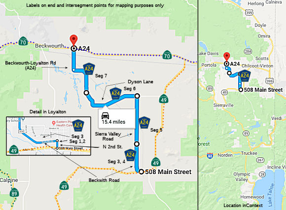 Sherman Street in Loyalton from Route 49 (Main Street) to N Second Street (0.05
mi) [Sierra County]. Note: There does not appear to be a Sherman Street in
Loyalton, so this road may have been renamed or eliminated.
Sherman Street in Loyalton from Route 49 (Main Street) to N Second Street (0.05
mi) [Sierra County]. Note: There does not appear to be a Sherman Street in
Loyalton, so this road may have been renamed or eliminated.
N Second Street in Loyalton from Sherman Street to Church Street
Beckwith Road (0.20 mi) [Sierra County]. Note: The definition
is to Church Road, but that's 2 blocks N of Beckwith, with no segment
returning to Beckwidth. So they likely meant Beckwith and this is an entry
error.
Beckwith Road in Loyalton from N Second Street to the Loyalton city limits (0.18 mi) [Sierra County]
Beckwith Road from the Loyalton city limits to the Plumas County line (2.02 mi) [Sierra County]
Sierra Valley Road from the Sierra County line to Dyson Lane (3.75 mi) [Plumas County]
Dyson Lane from Sierra Valley Road to Beckwourth Loyalton Road (4.83 mi) [Plumas County]
Beckwourth Loyalton Road from Dyson Lane to Route 70 (4.32 mi) [Plumas County]. Note: Google Maps does not show a road with this name, just "A24".
 History and Signage Information
This route was defined in 1961.
 Status
Total mileage: 15.35 mi
© 1996-2020 Daniel P. Faigin.
Maintained by: Daniel P. Faigin
<webmaster@cahighways.org>.
 CR A23
 CR A25