
 California Highways:
[Click here for a key to the symbols used. Some county routes were constructed with federal funds. These routes are indicated as FAP (Federal Aid Primary), FAU (Federal Aid Urban), or FAS (Federal Aid Secondary). If no funding source is shown, no federal funds were used. Note that while some segments seem to have the same attributes, they may differ in the county-local road number assigned to the segment, or in the Caltrans Map Sheet number.]
 Routing
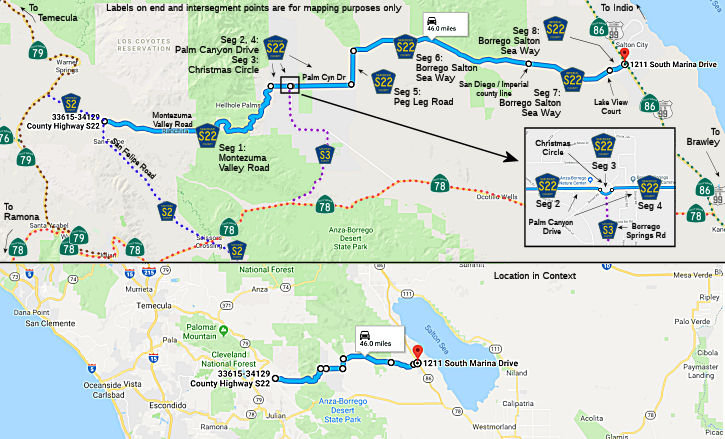 Montezuma Valley Road from San Felipe Road (County Sign Route S2) to Palm Canyon Drive (FAS, 18.70
mi) [San Diego County]
Montezuma Valley Road from San Felipe Road (County Sign Route S2) to Palm Canyon Drive (FAS, 18.70
mi) [San Diego County]
Palm Canyon Drive from Montezuma Valley Road to Christmas Circle (FAS, 1.36 mi) [San Diego County]
Christmas Circle from Palm Canyon Drive to Palm Canyon Drive (FAS, 0.31 mi) [San Diego County]
Palm Canyon Drive from Christmas Circle to Peg Leg Road (FAS, 4.21 mi) [San Diego County]
Peg Leg Road from Palm Canyon Road to Borrego Salton Sea Way (FAS, 2.63 mi) [San Diego County]
Borrego Salton Sea Way from Peg Leg Road to the Imperial county line (FAS, 13.02 mi) [San Diego County]
Borrego Salton Sea Way from the San Diego county line to Lake View Court (FAS, 5.96 mi) [Imperial County]
Borrego Salton Sea Way from Lake View Court to Route 86 (FAS, 1.32 mi) [Imperial County]
 History and Signage Information
This route was defined in 1968.
 National Trails
 This route is part of the De Anza National Historic Trail.
 Status
Total mileage: 47.51 mi.
© 1996-2020 Daniel P. Faigin.
Maintained by: Daniel P. Faigin
<webmaster@cahighways.org>.
 CR S21
 CR S24