
 California Highways:
[Click here for a key to the symbols used. Some county routes were constructed with federal funds. These routes are indicated as FAP (Federal Aid Primary), FAU (Federal Aid Urban), or FAS (Federal Aid Secondary). If no funding source is shown, no federal funds were used. Note that while some segments seem to have the same attributes, they may differ in the county-local road number assigned to the segment, or in the Caltrans Map Sheet number.]
 Routing
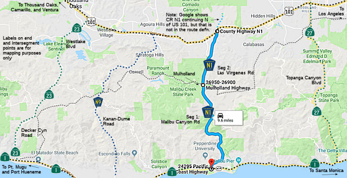 Malibu Canyon Road from Route 1 to Las Virgenes Road (FAS, 3.50 mi)
Las Virgenes Road from Malibu Canyon Road to US 101 (FAS, 5.00 mi)
Note: Google Maps shows County Sign Route N1 continuing N along Las Virgenes Road from US 101, but that portion is not signed N1 nor is there any other evidence of the designation.
 History and Signage Information
Malibu Canyon Road was constructed in 1951. A road from the San Fernando
Valley (Las Virgenes Road) had previously been constructed to the crest of
the Santa Monica Mountains, and was slowly making its way down-slope
toward the sea. The County decided to improve and extend the Malibu Canyon
road the Rindges (owners of the Rancho Malibu) had made, leading from the
coast up to the Ringe dam, in order to meet the Las Virgenes Road. They
did this using County jail inmates as labor (a common procedure at the
time). The camp to house inmates working on the road can be seen at the
left of the photo, just above the abandoned Rindge dam. Labeled "the road
from the Valley to the Sea", it was opened in 1952.
(Source: Historic Adamson House and Malibu Lagoon Museum)
 Scenic Highway
[SHC 154.1] from Route 1 to Lost Hills Road in Los Angeles County. Authorized by AB 1070, Chapter 758, 10/12/2001.
History and Signage InformationThis route was defined in 1963. Note that the routing of Malibu Canyon / Las Virgenes was originally proposed as the approximate routing for the N/S segment of Route 64.
 Other WWW Links
 Status
Total mileage: 8.50 mi.
The SAFETEA-LU act, enacted in August 2005 as the reauthorization of TEA-21, provided the following expenditures on or near this route:
In October 2017, it was reported that, after nearly two years of
construction, the Las Virgenes Road widening in Calabasas is complete.
Mayor Mary Sue Maurer presented the finished project with a public
ribbon-cutting on Sept. 26, 2017. The 1.5-mile stretch from Lost Hills
Road to Agoura Road now has two traffic lanes in each direction to
accommodate the additional cars and trucks from several new development
projects along Las Virgenes. The Calabasas job also includes new sidewalks
and two new traffic signals at Willow Glen Road and Oak Glen Street. Other
highlights are a new 5-foot bicycle lane, a raised landscaped median, and
a crosswalk to give pedestrians safer access to the middle school and the
Calabasas Bark Park. The city used $5.7 million dollars in Los Angeles
County Measure R funds to pay for the job. The project was approved by the
Metropolitan Transportation Authority and construction began early last
year. A small section of the road improvement around Las Virgenes Road and
Oak Glen Street was paid for by Calabasas Blue, the developer of the
78-home Paxton neighborhood that is under construction on the east side of
Las Virgenes.
(Source: The Acorn, 10/18/2017)
© 1996-2020 Daniel P. Faigin.
Maintained by: Daniel P. Faigin
<webmaster@cahighways.org>.
 CR J132
 CR N2
CR N2