
 California Highways:
[Click here for a key to the symbols used. Some county routes were constructed with federal funds. These routes are indicated as FAP (Federal Aid Primary), FAU (Federal Aid Urban), or FAS (Federal Aid Secondary). If no funding source is shown, no federal funds were used. Note that while some segments seem to have the same attributes, they may differ in the county-local road number assigned to the segment, or in the Caltrans Map Sheet number.]
 Routing
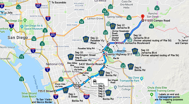 E Street in Chula Vista from I-5 to Bonita Road (FAU, 2.09 mi)
Bonita Road in Chula Vista from E Street to the Chula Vista city limits (FAU, 0.25 mi)
Bonita Road from the Chula Vista city limits to Glen Abbey Blvd (FAU, 0.32 mi)
Bonita Road from Glen Abbey Blvd to Glen Abbey Blvd (FAU, 0.56 mi)
Bonita Road from Glen Abbey Blvd to the Chula Vista city limits (FAU, 0.69 mi)
Bonita Road in Chula Vista from the Chula Vista city limits to Otay Lakes Road (FAU, 0.62 mi)
Bonita Road from Otay Lakes Road to San Miguel Road (FAU, 1.35 mi)
Bonita Road from San Miguel Road to Sweetwater Road (FAU, 0.26 mi)
Sweetwater Road from Bonita Road to the South Bay Freeway (Route 54) (FAU, 1.06 mi)
Worthington Street from the South Bay Freeway (Route 54) to Paradise Valley Road (FAU, 0.43 mi)
Paradise Valley Road from Worthington Street to Jamacha Blvd
Sweetwater Road (FAU, 0.70 mi)
Jamacha Blvd Sweetwater Road from Paradise Valley
Road to Jamacha Blvd (FAU, 0.10 mi)
Jamacha Blvd from Sweetwater Road to Grand Avenue (FAU, 0.79 mi)
Jamacha Blvd from Grand Avenue to Route 94 (FAU, 3.68 mi)
 History and Signage Information
This route was defined in 1964.
 Status
Total mileage: 12.90 mi. This route is unsigned.
© 1996-2020 Daniel P. Faigin.
Maintained by: Daniel P. Faigin
<webmaster@cahighways.org>.
 CR S16
 CR S18