
 California Highways:
[Click here for a key to the symbols used. Some county routes were constructed with federal funds. These routes are indicated as FAP (Federal Aid Primary), FAU (Federal Aid Urban), or FAS (Federal Aid Secondary). If no funding source is shown, no federal funds were used. Note that while some segments seem to have the same attributes, they may differ in the county-local road number assigned to the segment, or in the Caltrans Map Sheet number.]
 Routing
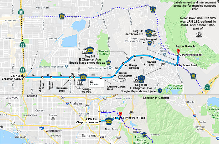 Chapman Avenue in Orange from Route 55 to McPherson Street (FAU, 0.53 mi)
Chapman Avenue from McPherson Street to Prospect Street (FAU, 0.20 mi)
Chapman Avenue in Orange from Prospect Street to Esplanade Street (FAU, 0.50 mi)
Chapman Avenue from Esplanade Street to the Orange city limits (FAU, 0.13 mi)
Chapman Avenue in Orange from the Orange city limits to Crawford Canyon Road (FAU, 0.69 mi)
Chapman Avenue from Crawford Canyon Road to Old Chapman Avenue (FAU, 0.32 mi)
Chapman Avenue in Orange from Old Chapman Avenue to the Orange city limits (FAU, 0.52 mi)
Chapman Avenue from the Orange city limits to the Orange city limits (FAU, 0.35 mi)
Chapman Avenue in Orange from the Orange city limits to Newport Blvd (FAU, 0.52 mi)
Chapman Avenue from Newport Blvd to Santiago Canyon Road (FAU, 0.37 mi)
Jamboree Road Chapman Avenue from Santiago Canyon
Road to Irvine Park (0.87 mi) [Note: This segment is really part of County Sign Route S18]
 History and Signage Information
This route was defined in 1970. It appears to have been one-time LRN 182.
 Status
Total mileage: 5.00 mi.
© 1996-2020 Daniel P. Faigin.
Maintained by: Daniel P. Faigin
<webmaster@cahighways.org>.
 CR S24
 CR S26