
 California Highways:
[Click here for a key to the symbols used. Some county routes were constructed with federal funds. These routes are indicated as FAP (Federal Aid Primary), FAU (Federal Aid Urban), or FAS (Federal Aid Secondary). If no funding source is shown, no federal funds were used. Note that while some segments seem to have the same attributes, they may differ in the county-local road number assigned to the segment, or in the Caltrans Map Sheet number.]
 Routing
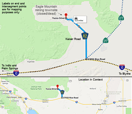 Kaiser Road from Route 177 to Eagle Mountain (11.26 mi)
 History and Signage Information
This route was defined in 1964.
The route was constructed to Eagle Mountain as Kaiser had a huge mining
operation there, north of Desert Center, until it ran dry about 25 years
ago -- complete with a dedicated rail line (the Eagle Mountain Railroad)
which ferried the loads from the mine to the SP (now UP) main line on the
northeast shore of the Salton Sea. The product of this mining was used on
the local roads in the area. The high concentration of iron particles
accounts for the reddish tint to the rock materials sourced locally.
Currently, Eagle Mountain is boarded up and fenced -- you can tell it was
a company mining town and some of the machinery can still be seen west of
Desert Center on I-10. The local gossip was that the Marines out of 29
Palms were using the site for urban combat exercises, which would explain
why it was boarded up and fenced so well.
(Source: Sparker and Max Rockatansky, discussion on
AAroads)
In May 2023, it was reported that Eagle Mountain has been sold to a
mysterious buyer whose plans are unclear. Eagle Mountain, located in
Riverside County near the southeast corner of Joshua Tree National Park,
was once a bustling iron mine (and the terminus of County Sign Route R2). The 10,000-acre
site has sold for nearly $22.6 million, according to Securities and
Exchange Commission records. With the decline of steel manufacturing, the
mine and town shut down in 1983. A private company tried and failed to
convert it to the Eagle Mountain Landfill and Recycling Center. In 2000,
Los Angeles County went into escrow to buy the land for $41 million for
use as what would have been the country’s largest landfill. But the
plan was caught in a decades-long legal battle and never came to fruition.
In 2015, Eagle Crest Energy Co. bought the land and attained a license to
build a $2.5-billion hydro power plant in the former mine. The plan faced
pushback from conservation groups over the possible depletion of
groundwater. On Oct. 12, 2022, Eagle Crest Energy Co. submitted an amended
hydroelectric application to the Federal Energy Regulatory Commission,
seeking to change the project’s boundary. An SEC filing describes
the next development in the property’s saga as taking place April
17, when Eagle Mountain Acquisitions sold what it called Kaiser Eagle
Mountain to Ecology Mountain Holdings. The price: $22,580,000. It is
unlikely this will result in County Sign Route R2 being re-signed.
(Source: SFGate, 5/21/2023; Los Angeles Times, 5/23/2023)
© 1996-2020 Daniel P. Faigin.
Maintained by: Daniel P. Faigin
<webmaster@cahighways.org>.
 CR R1
CR R1 CR R3
CR R3