
 California Highways:
[Click here for a key to the symbols used. Some county routes were constructed with federal funds. These routes are indicated as FAP (Federal Aid Primary), FAU (Federal Aid Urban), or FAS (Federal Aid Secondary). If no funding source is shown, no federal funds were used. Note that while some segments seem to have the same attributes, they may differ in the county-local road number assigned to the segment, or in the Caltrans Map Sheet number.]
 Routing
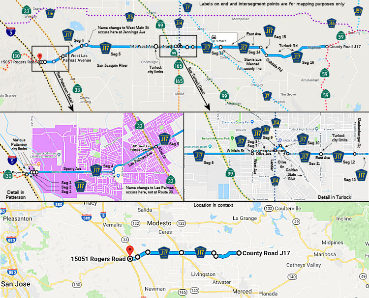 Sperry Avenue from I-5 to the Patterson city limits (FAS, 2.56 mi) [Stanislaus County]
Sperry Avenue in Patterson from the Patterson city limits to the Patterson city limits (FAS, 0.17 mi) [Stanislaus County]
Sperry Avenue outside Patterson from the Patterson city limits to the Patterson city limits (FAS, 0.16 mi) [Stanislaus County]
Sperry Avenue in Patterson from the Patterson city limits to Route 33 (FAS, 0.29 mi) [Stanislaus County]
Las Palmas Avenue in Patterson from Route 33 to First Street (FAS, 0.10 mi) [Stanislaus County]
Las Palmas Avenue from First Street to the San Joaquin River (FAS, 2.94 mi) [Stanislaus County]
West Main Street from the San Joaquin River to the Turlock city limits (FAS, 11.46 mi) [Stanislaus County]
West Main Street in Turlock from the Turlock city limits to West Avenue (FAS, 1.00 mi) [Stanislaus County]
West Avenue in Turlock from West Main Street to Olive Avenue (FAU, 0.06 mi) [Stanislaus County]
Olive Avenue in Turlock from West Street to Lander Avenue (FAU, 0.50 mi) [Stanislaus County]
Olive Avenue in Turlock from Lander Avenue to Golden State Blvd (FAU, 0.18 mi) [Stanislaus County]
 Status
This segment is cosigned with County Sign Route J14.
Golden State Blvd in Turlock from Olive Avenue to East Avenue (FAU, 0.25 mi) [Stanislaus County]
East Avenue in Turlock from Golden State Blvd to the Turlock city limits (FAU, 0.84 mi) [Stanislaus County]
East Avenue from the Turlock city limits to Daubenberger Road (FAU, 0.64 mi) [Stanislaus County]
East Avenue from Daubenberger Road to the Merced county line (FAS, 3.59 mi) [Stanislaus County]
East Avenue from the Stanislaus county line to Oakdale Road (FAS, 5.00 mi) [Merced County]
Oakdale Road from East Avenue to Turlock Road (FAS, 1.24 mi) [Merced County]
Turlock Road from Oakdale Road to Route 59 (FAS, 8.40 mi) [Merced County]
 History and Signage Information
This route was defined in 1960.
StatusTotal mileage: 39.20 mi.
© 1996-2020 Daniel P. Faigin.
Maintained by: Daniel P. Faigin
<webmaster@cahighways.org>.
 CR J16
 CR J18