
 California Highways:
[Click here for a key to the symbols used. Some county routes were constructed with federal funds. These routes are indicated as FAP (Federal Aid Primary), FAU (Federal Aid Urban), or FAS (Federal Aid Secondary). If no funding source is shown, no federal funds were used. Note that while some segments seem to have the same attributes, they may differ in the county-local road number assigned to the segment, or in the Caltrans Map Sheet number.]
 Routing
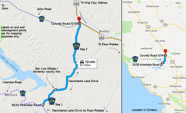 Nacimiento Lake Drive from Interlake Road (County Sign Route G14) to the Monterey county line (FAS,
1.50 mi) [San Luis Obispo County]
Nacimiento Lake Drive from Interlake Road (County Sign Route G14) to the Monterey county line (FAS,
1.50 mi) [San Luis Obispo County]
Nacimiento Lake Drive from the San Luis Obispo county line to Jolon Road (County Sign Route G18) (FAS, 7.00 mi) [Monterey County]
 History and Signage Information
County Sign Route G19 had its start in Godfrey Road, which existed as early as 1919, as
it was shown on the United States Geological Survey map of Bradley from
that time. The road descended to the San Antonio River via Bee Rock
Canyon and Branch Ranch. The road emerged from what is now Vista
Lane and crossed the San Antonio River via ford located east of the modern
highway bridge near Pleyto Well. Much of the roadway north of the
river is the same as modern County Sign Route G19 to Jolon Road (County Sign Route J18). During 1921,
Monterey County constructed a single-lane four span Pratt Truss at the San
Antonio River on Godfrey Road. The structure was 292 feet long and
was the only bridge over the river for several years. During 1956, the
Monterey County Water Resource Agency completed Nacimiento Dam on the
namesake river in northern San Luis Obispo County. In 1965, the
agency would complete San Antonio Dam. Concurrent to the
construction of both dams, Godfrey Road was relocated out of Bee Rock
Canyon, and a new alignment was constructed through Sulphur Canyon to
Interlake Road in San Luis Obispo County to provide better connectivity
with the two reservoirs.
(Source: Gribblenation Blog (Tom Fearer): "San Luis Obispo/Monterey County Route G19", November 2024)
In 1971, Godfrey Road was designated as County Sign Route G19
By 1976, Godfrey Road used Sulphur Canyon to reach Interlake Road.
Godfrey Road was later renamed "Nacimiento Lake Drive." During June
2020, the Monterey County Board of Supervisors approved replacing the 1921
San Antonio River Bridge. The structure was replaced with a new
bridge during 2023. The southern approach to the 1921 span was
preserved and a historic plaque was installed. .
(Source: Gribblenation Blog (Tom Fearer): "San Luis Obispo/Monterey County Route G19", November 2024)
 Other WWW Links
 Status
Total mileage: 8.50 mi.
© 1996-2024 Daniel P. Faigin.
Maintained by: Daniel P. Faigin
<webmaster@cahighways.org>.
 CR G18
 CR G20