
 California Highways:
[Click here for a key to the symbols used. Some county routes were constructed with federal funds. These routes are indicated as FAP (Federal Aid Primary), FAU (Federal Aid Urban), or FAS (Federal Aid Secondary). If no funding source is shown, no federal funds were used. Note that while some segments seem to have the same attributes, they may differ in the county-local road number assigned to the segment, or in the Caltrans Map Sheet number.]
 Routing
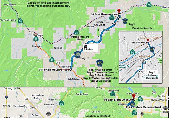 Portola McLears Road between Route 89 and the Portola city limits (7.11 mi)
 Status
In December 2009, the CTC approved for future funding a project that will reconstruct approximately 3,140 linear feet of Road A15, also known as Portola McLears Road. The existing pavement width varies and low or no shoulders are typical along the length of the project. The pavement is in poor condition with severe cracking, rutting and pot holes. The proposed reconstruction will include widening the road to a 24 ft paved traveled way, adding 6’ shoulders on each side, reconstructing 5 driveway/road approaches, and other improvements. The project is estimated to cost $ 2,943,000 and is fully programmed in the STIP. Construction is estimated to begin in FY 2009/10. On October 6, 2009, the City provided confirmation that the preferred alternative set forth in the final environmental document is consistent with the project scope of work programmed by the Commission.
Portola McLears Road from the Portola city limits to Main Street, Portola (0.60 mi). Note: This appears to include small runs on Colorado St. and Third Ave in the city limits.
Main Street in Portola from Portola McLears Road (Third Ave) to Western Pacific Way/First Avenue (0.10 mi)
Western Pacific Way/First Street in Portola from Main Street to Pacific Street (0.06 mi)
Pacific Street in Portola from First Street to Commercial Street (0.05 mi)
Commercial Street in Portola from Pacific Street to Gulling Street (0.18 mi)
Gulling Street in Portola from Commercial Avenue to Route 70 (0.25 mi)
 History and Signage Information
This route was defined in 1959.
 Other WWW Links Status
Total Mileage: 8.35 mi.
© 1996-2020 Daniel P. Faigin.
Maintained by: Daniel P. Faigin
<webmaster@cahighways.org>.
 CR A14
 CR A16