
 California Highways:
[Click here for a key to the symbols used. Some county routes were constructed with federal funds. These routes are indicated as FAP (Federal Aid Primary), FAU (Federal Aid Urban), or FAS (Federal Aid Secondary). If no funding source is shown, no federal funds were used. Note that while some segments seem to have the same attributes, they may differ in the county-local road number assigned to the segment, or in the Caltrans Map Sheet number.]
 Routing
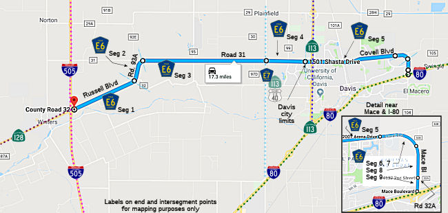 Russell Blvd from the Route 128/I-505 junction to Road 93A (FAS, 2.80 mi)
Road 93A from Russell Blvd to Road 31 (FAS, 1.22 mi)
Road 31 from Road 93A to (former) Route 113 (FAS, 7.13 mi). Note: Given that Route 113 is now within the Davis city limits, the "Route 113" reference here likely refers to Perdick Road (former Lincoln Highway), now County Sign Route E7, which is just outside the Davis city limits.
Road 31 from (former) Route 113 to the Davis city limits (FAU, 0.35 mi)
Covell Blvd in Davis (FAU, 2.08 mi)
Covell Blvd from the Davis city limits to the Davis urban limit (FAU, 0.65 mi). Note: It is unclear exactly where the "urban limits" are.
Covell Blvd from the Davis urban limit to Mace Blvd (FAS, 1.26 mi)
Mace Blvd from Covell Blvd to Road 32A (FAS, 0.30 mi)
Mace Blvd from Road 32A to I-80 E of Davis (FAU, 0.14 mi)
 History and Signage Information
This route was defined in 1968.
 Status
Total mileage: 15.93 mi.
© 1996-2020 Daniel P. Faigin.
Maintained by: Daniel P. Faigin
<webmaster@cahighways.org>.
 CR E5
CR E5 CR E7
CR E7