
 California Highways:
[Click here for a key to the symbols used. Some county routes were constructed with federal funds. These routes are indicated as FAP (Federal Aid Primary), FAU (Federal Aid Urban), or FAS (Federal Aid Secondary). If no funding source is shown, no federal funds were used. Note that while some segments seem to have the same attributes, they may differ in the county-local road number assigned to the segment, or in the Caltrans Map Sheet number.]
 Routing
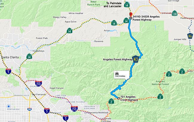 Angeles Forest Highway between Sierra Highway (Route 14) and Angeles Crest Highway
(Route 2) (FAS, 25.03 mi)
Angeles Forest Highway between Sierra Highway (Route 14) and Angeles Crest Highway
(Route 2) (FAS, 25.03 mi)
Note: There is no signage along this route to indicate it is County Sign Route N3, except for the occasional call-box showing N3. It is, however, well maintained with county postmiles and beautiful views.
 History and Signage Information
During 1915, the corridor of what would become Angeles Forest Highway was defined as a new state highway via 1915 Legislative Chapter 704. which defined the Pasadena State Highway with the following description:
"La Canada valley with the Antelope Valley...starting 2 mi NE of La Canada thence following the N and NW-ly the Arroyo Seco to a point E of Hoyt Ranch; thence NE-ly following Tujunga Cyn and Mill Creek to Tie Cyn; thence NW-ly by way of Kennedy Springs to Vincent."
Vincent appears to be where Pearblossom Highway and Route 14 come
together; Tie Canyon is along Angeles Forest Highway. However, 1915
Legislative Chapter 704 only provided funding for a survey for through the
San Gabriel Mountains but not actual construction. The survey
routing would be clarified by the 1919 Third State Highway Bond Act as "La
Canada to Mount Wilson Road via Arroyo Seco." The 1919 Third State
Highway Bond Act provided construction funding. Internally this was number
was Rte. 61, and in 1935 it became LRN 61. The new LRN 61 routing
corresponded to Route 2; the previous routing north through Tujunga
Canyon, Mill Creek, Tie Canyon and Kennedy Springs to Vincent was not
constructed by the state.
(Source: Gribblenation Blog (Tom Fearer), "Angeles Forest Highway (Los Angeles County Route N3)", 9/5/2023)
During the 1920s the Edison Pole Line Road was constructed north of LRN 61 to Vincent. Edison Pole Line Road was constructed by Southern
California Edison to permit their vehicles access to power line
infrastructure.
(Source: Gribblenation Blog (Tom Fearer), "Angeles Forest Highway (Los Angeles County Route N3)", 9/5/2023)
During 1928 the Los Angeles County Board of Supervisors would approve the
commissioning of Angeles Forest Highway. The routing of Angeles
Forest Highway would comprise much of the corridor defined by 1915
Legislative Chapter 706. Surveys for the construction of Angeles
Forest Highway by Los Angeles County were conducted during 1931. The
routing of Angeles Forest Highway would require construction of a bridge
and tunnel at Mill Creek. Edison Pole Line Road crossed Big Tujunga
Creek, Fall Creek, Lucas Creek, Mill Creek and Fall Creek again via what
is now Forest Road 3N27/North Fork Mill Creek Road. Edison Pole Line
Road continued north following North Fork Mill Creek near Mount Gleason to
Aliso Canyon Road (modern Forest Road 3N27, Mount Gleason Road/Forest Road
3N17 and Bear Trap Canyon Road). North of Aliso Canyon Road, the
alignment of Edison Pole Line Road follows what often appears now on maps
as Edison Road towards Vincent. Angeles Forest Highway was completed
on September 12, 1941, following the completion of the Armstong Memorial
Bridge over Mill Creek and the Mill Creek Tunnel. Angeles Forest
Highway was dedicated on September 15, 1941.
(Source: Gribblenation Blog (Tom Fearer), "Angeles Forest Highway (Los Angeles County Route N3)", 9/5/2023)
The Angeles Forest Highway, aka the Palmdale Cut-Off, was surveyed in 1913, approved in 1928 to roughly follow the Edison pole line road, and built from 1932 to 1941.
In 1959, Legislative Chapter 1062 defined the general corridor of Angeles Forest Highway as part of planned LRN 266 and as part of the Freeway & Expressway System. In 1964, LRN 266 was designated as Route 249.
County Sign Route N3 was formally defined in 1963.
 Naming
In November 2010, it was reported that the LA County Board of Supervisors dedicated a section of the Angeles Forest Highway in honor of the two Los Angeles County firefighters who lost their lives on duty battling the Station Fire ("Captain Ted Hall and Engineer Arnie Quinones Memorial Highway"). Captain Ted Hall and Engineer Arnie Quinones died on August 30th, 2009 when their truck plunged 800 feet off the side of a road near Mount Gleason. Less than a month later, Quinones' widow, Lori, gave birth to the couple's first child, a daughter. Hall and Quinones were honored with a large public memorial held at Dodger Stadium, while the Station Fire--the largest in LA County history--continued to burn. Signs have been affixed at both the northbound and southbound (one-quarter mile south of Sierra Highway) entrances to the highway.
 Other WWW Links
© 1996-2020 Daniel P. Faigin.
Maintained by: Daniel P. Faigin
<webmaster@cahighways.org>.
 CR N2
CR N2 CR N4
CR N4