
 California Highways:
[Click here for a key to the symbols used. Some county routes were constructed with federal funds. These routes are indicated as FAP (Federal Aid Primary), FAU (Federal Aid Urban), or FAS (Federal Aid Secondary). If no funding source is shown, no federal funds were used. Note that while some segments seem to have the same attributes, they may differ in the county-local road number assigned to the segment, or in the Caltrans Map Sheet number.]
 Routing
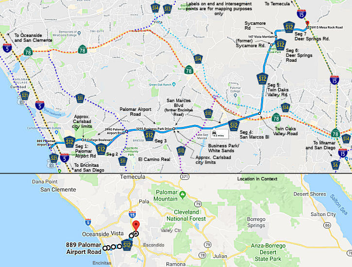 Palomar Airport Road in Carlsbad from Carlsbad Blvd (County Sign Route S21) to the Carlsbad city
limits (FAU, 1.20 mi)
Palomar Airport Road in Carlsbad from Carlsbad Blvd (County Sign Route S21) to the Carlsbad city
limits (FAU, 1.20 mi)
Palomar Airport Road from the Carlsbad city limits to El Camino Real (County Sign Route S11) (FAU, 2.77 mi)
Palomar Airport Road in Carlsbad from El Camino Real (County Sign Route S11) to the Carlsbad city limits (FAU, 2.16 mi)
Palomar Airport Road from the Carlsbad city limits to Business Park/White Sands Drive (where it turns into San Marcos Blvd), and then as San Marcos Blvd to Twin Oaks Valley Road in San Marcos (FAU, 4.14 mi)
 History and Signage Information
It looks like this actually used to be the following:
At some point, Encinitas Road was renamed as San Marcos Drive, and it looks like Linda Vista was renamed to Business Park/White Sands Dr..
Twin Oaks Valley Road in San Marcos from San Marcos Blvd (previously Encinitas Road) to Deer Springs Road (previously Sycamore Road) (FAU, 3.10 mi)
Deer Springs Road (previously Sycamore Road) from Twin Oaks Valley Road to Deer Springs Road & Sycamore Road (FAU, 0.48 mi)
Deer Springs Road from Sycamore Road to I-15 (FAU, 1.66 mi)
History and Signage InformationThis route was defined in 1961.
 Status
Total mileage: 15.51 mi.
© 1996-2020 Daniel P. Faigin.
Maintained by: Daniel P. Faigin
<webmaster@cahighways.org>.
 CR S11
 CR S13