
 California Highways:
[Click here for a key to the symbols used. Some county routes were constructed with federal funds. These routes are indicated as FAP (Federal Aid Primary), FAU (Federal Aid Urban), or FAS (Federal Aid Secondary). If no funding source is shown, no federal funds were used. Note that while some segments seem to have the same attributes, they may differ in the county-local road number assigned to the segment, or in the Caltrans Map Sheet number.]
 Routing
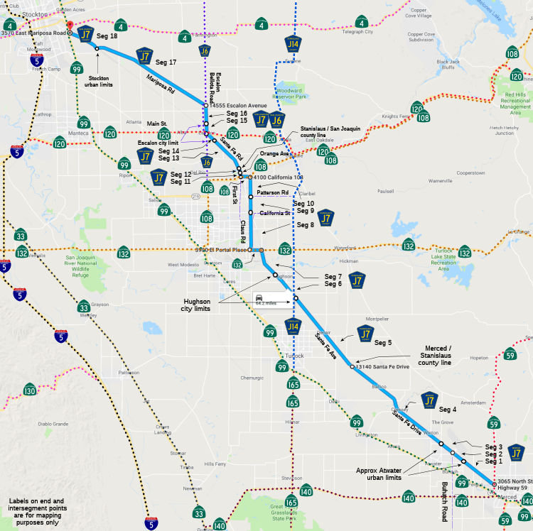 Santa Fe Drive from Route 59 near Merced to the Atwater urban limits (FAS, 4.53 mi)
[Merced County]
Santa Fe Drive from Route 59 near Merced to the Atwater urban limits (FAS, 4.53 mi)
[Merced County]
Santa Fe Drive from the Atwater urban limits to Buhach Road (FAU, 0.45 mi) [Merced County]
Santa Fe Drive from Buhach Road to the Atwater urban limits (FAU, 0.31 mi) [Merced County]
Santa Fe Drive from the Atwater urban limits to the Stanislaus county line (FAS, 13.26 mi) [Merced County]
Santa Fe Avenue from the Merced county line to the Hughson city limits (FAS, 9.10 mi) [Stanislaus County]
Santa Fe Avenue in Hughson (FAS, 0.96 mi) [Stanislaus County]
Santa Fe Avenue from the Hughson city limits to Route 132 (FAS, 3.24 mi) [Stanislaus County]
Claus Road from Route 132 to California Avenue Street
(FAS, 6.34 mi) [Stanislaus County]
Claus Road in Riverbank from California Avenue Street
to Patterson Road (FAS, 0.25 mi) [Stanislaus County]
Claus Road from Patterson Road to Route 108 (FAS, 0.31 mi) [Stanislaus County]
First Street in Riverbank from Route 108 to Orange Avenue (FAS, 0.21 mi) [Stanislaus County]
First Street from Orange Avenue to the San Joaquin county line (FAS, 0.09 mi) [Stanislaus County]
Santa Fe Avenue Road from the Stanislaus county
line to the Escalon city limits (FAS, 4.09 mi) [San Joaquin County]
Main Street in Escalon from the Escalon city limits to Route 120 (FAS, 0.92 mi) [San Joaquin County]
Escalon Bellota Road in Escalon from Route 120 to the Escalon city limits (FAS, 0.30 mi) [San Joaquin County]
Escalon Bellota Road from the Escalon city limits to Mariposa Road (FAS, 2.20 mi) [San Joaquin County]
Mariposa Road from Escalon Bellota Road to the Stockton urban limits (FAS, 14.15 mi) [San Joaquin County]
Mariposa Road from the Stockton urban limits to Route 99 (FAS, 0.70 mi) [San Joaquin County]
 History and Signage Information
This route was defined in 1960.
 Status
Total mileage: 58.91 mi. The segment between Route 120 and Mariposa Road is cosigned with County Sign Route J6
 Other WWW Links
© 1996-2020 Daniel P. Faigin.
Maintained by: Daniel P. Faigin
<webmaster@cahighways.org>.
 CR J6
CR J6 CR J8
CR J8