
 California Highways:
[Click here for a key to the symbols used. Some county routes were constructed with federal funds. These routes are indicated as FAP (Federal Aid Primary), FAU (Federal Aid Urban), or FAS (Federal Aid Secondary). If no funding source is shown, no federal funds were used. Note that while some segments seem to have the same attributes, they may differ in the county-local road number assigned to the segment, or in the Caltrans Map Sheet number.]
 Routing
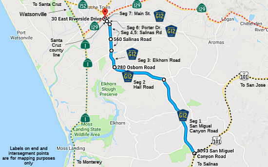 San Miguel Canyon Road from US 101 to Hall Road (FAS, 4.65 mi) [Monterey County]
Hall Road from San Miguel Canyon Road to Elkhorn Road (FAS, 2.85 mi) [Monterey County]
Elkhorn Road from Hall Road to Salinas Road (FAS, 1.12 mi) [Monterey County]
Salinas Road from Elkhorn Road to the Watsonville urban limits (FAS, 0.95 mi) [Monterey County]
Salinas Road from the Watsonville urban limits to Porter Drive
Road (FAU, 0.55 mi) [Monterey County]
Porter Road from Salinas Road to the Santa Cruz county line (FAU, 0.22 mi)
Main Street in Watsonville from the Monterey county line to Route 129 (FAU, 0.20) [Santa Cruz County]
 History and Signage Information
This route was defined in 1965.
 Status
In December 2017, the Monterey County RTIP noted for this route the
following proposal: Monterey County G12 Operational and Capacity
Improvements: This County project will widen San Miguel Canyon
Road to four lanes between Castroville Boulevard and Hall Road, and Hall
Road between San Miguel Canyon Road and Elkhorn Road. Class II bike lanes
will be installed and maintained throughout widened segment. Traffic
signal and intersection improvements will be constructed on San Miguel
Canyon Road at Castroville Boulevard. Intersection improvements will be
constructed onHall Road at Sill Road andWillow Road. Intersection
improvements will also be constructed on San Miguel Canyon Road at Moro
Road and Langley Canyon Road.
(Source: TAMC RTIP 12/2017)
Total mileage: 10.54 mi.
© 1996-2020 Daniel P. Faigin.
Maintained by: Daniel P. Faigin
<webmaster@cahighways.org>.
 CR G11
 CR G13