
 California Highways:
[Click here for a key to the symbols used. Some county routes were constructed with federal funds. These routes are indicated as FAP (Federal Aid Primary), FAU (Federal Aid Urban), or FAS (Federal Aid Secondary). If no funding source is shown, no federal funds were used. Note that while some segments seem to have the same attributes, they may differ in the county-local road number assigned to the segment, or in the Caltrans Map Sheet number.]
 Routing
 History and Signage Information
County Sign Route J132 was defined in 1961. It seems likely the definition fell in line
with the realigned Route 49 pushing Route 132 into downtown Coulterville
with the completion of the 1963 Maxwell Creek Bridge.
(Source: Gribblenation Blog "California State Route 132 and Signed County Route J132")
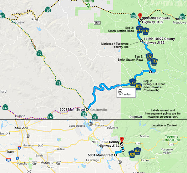
According to the maps in the Gribblenation blog on the Old Coulterville
Road, the path of the Old Coulterville Road follows County Sign Route J132 via Main
Street and Greeley Hill Road eastward towards the intersection with Smith
Station Road. County Sign Route J132/Old Coulterville Road on Main Street is co-signed as
the Historic John Muir Route. East of Redcould Park County Sign Route J132 descends a
series of hills and splits from Greeley Hill Road onto Smith Station Road.
The path of the Old Coulterville Road remains on Greeley Hill Road east of
the Smith Station Road intersection.
(Source: Gribblenation Blog: "The Old Coulterville Road; the first Highway to Yosemite Valley")
 Status
This route is signed as J132 several times in Mariposa County, and again at the Mariposa/Tuolumne county border. There are no signs indicating "J20" (although the Compass map (1995) of Calaveras/Tuolumne counties does have it labeled as J20). It appears to be a continuation of Route 132.
This also appears to be referred to as County Sign Route J20. It is not in the Caltrans Database as County Sign Route J132; however, the route appears to be signed as both J132 and J20. It is possible the signed route database has been updated without the knowledge of CalTrans.
 Other WWW Links
© 1996-2020 Daniel P. Faigin.
Maintained by: Daniel P. Faigin
<webmaster@cahighways.org>.
 Greely Hill Road and Smith Station Road between Route
  CR J59
 CR N1
CR N1