
 California Highways:
[Click here for a key to the symbols used. Some county routes were constructed with federal funds. These routes are indicated as FAP (Federal Aid Primary), FAU (Federal Aid Urban), or FAS (Federal Aid Secondary). If no funding source is shown, no federal funds were used. Note that while some segments seem to have the same attributes, they may differ in the county-local road number assigned to the segment, or in the Caltrans Map Sheet number.]
 Routing
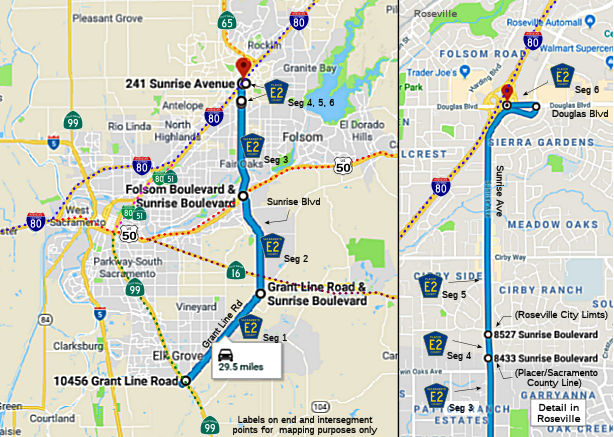 Grant Line Road from Route 99 to Sunrise Blvd (FAS, 10.20 mi) [Sacramento County]
Sunrise Blvd from Grant Line Road to Folsom Blvd (FAS, 8.80 mi) [Sacramento County]
Sunrise Blvd from Folsom Blvd to the Placer county line (FAU, 7.89 mi) [Sacramento County]
Sunrise Avenue from the Sacramento county line to the Roseville city limits (FAU, 0.12 mi) [Placer County]
Sunrise Avenue in Roseville from the city limits to Douglas Blvd (FAU, 1.68 mi) [Placer County]
Douglas Blvd in Roseville from Sunrise Avenue to I-80 (FAU, 0.20 mi) [Placer County]
 History and Signage Information
This route was defined in 1967.
 Status
Capitol Southeast Connector
 Segment 1 of this route is proposed as part of the Capitol Southeast Connector. In March 2013, it
was reported that local governments behind the proposed Capital Southeast
Connector on Friday approved a financing plan and design guidelines,
moving the massive project a big step forward. The proposed expressway
from Elk Grove to El Dorado County is envisioned as a way to ease traffic
congestion and boost the region's economy. The 35-mile route is expected
to cost $463 million in 2012 dollars through 2035. About $118 million
comes from a Sacramento County tax measure approved by voters in 2004.
Directors of the joint-powers agency that runs it —representing the
counties of Sacramento and El Dorado, as well as the cities of Elk Grove,
Folsom and Rancho Cordova — unanimously approved the project's
financing and design plans. As early as summer 2013, the local governments
could vote to commit funds to the project and empower the agency to take
full responsibility. Described as what would be the county’s largest
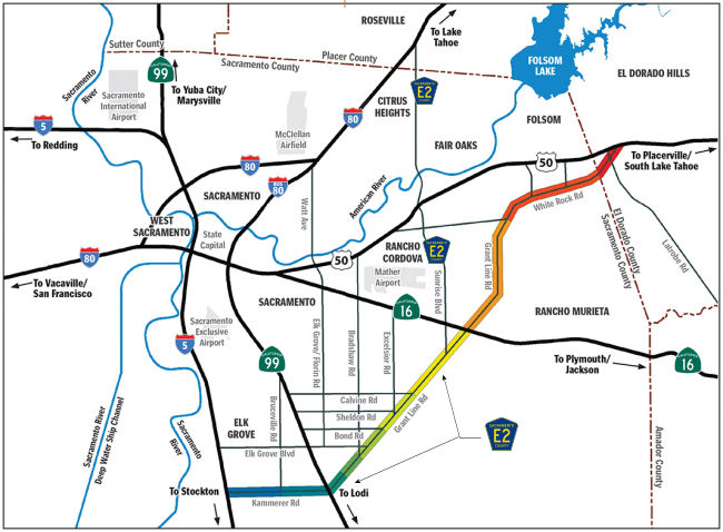
congestion-reducing road in decades, the project would link I-5 and Route 99 just south of Elk Grove, then run along Grant Line and White Rock roads
skirting Rancho Cordova and Folsom, finally connecting to US 50 in El
Dorado Hills. The expressway would consist of two to three lanes in each
direction.
Segment 1 of this route is proposed as part of the Capitol Southeast Connector. In March 2013, it
was reported that local governments behind the proposed Capital Southeast
Connector on Friday approved a financing plan and design guidelines,
moving the massive project a big step forward. The proposed expressway
from Elk Grove to El Dorado County is envisioned as a way to ease traffic
congestion and boost the region's economy. The 35-mile route is expected
to cost $463 million in 2012 dollars through 2035. About $118 million
comes from a Sacramento County tax measure approved by voters in 2004.
Directors of the joint-powers agency that runs it —representing the
counties of Sacramento and El Dorado, as well as the cities of Elk Grove,
Folsom and Rancho Cordova — unanimously approved the project's
financing and design plans. As early as summer 2013, the local governments
could vote to commit funds to the project and empower the agency to take
full responsibility. Described as what would be the county’s largest
congestion-reducing road in decades, the project would link I-5 and Route 99 just south of Elk Grove, then run along Grant Line and White Rock roads
skirting Rancho Cordova and Folsom, finally connecting to US 50 in El
Dorado Hills. The expressway would consist of two to three lanes in each
direction.
(Source: Sacramento Business Journal, 3/8/2013)
In December 2016, there was an update on the connector.
The effort suffered a setback in November 2016 when voters rejected
Measure B, the Sacramento County transportation half-cent sales tax that
would have provided $125 million for the project – more than a third
of the connector’s estimated $335 million construction cost. Despite
that, proponents say they intend to get the massive project built. They
just aren’t sure when. The planned connector would be a four-lane
expressway with a center median and a bike trail, much of it an expansion
of Grant Line Road and White Rock roads. It would connect to US 50 at the
Silva Valley interchange in El Dorado County at its northeast end, as well
as to Route 99 in south Elk Grove and I-5 south of Sacramento at its
southwest terminus. The current estimate is that it will take another
several decades to get the expressway built. Even then, it will be a
smaller road than first imagined. Previously, officials talked of building
six lanes in some spots, with interchanges instead of intersections, with
an estimated cost at one point of $700 million. Eventually, when expected
east county growth causes congestion on the new road, the connector could
be turned into a full expressway by turning intersections into
interchanges. The group built an initial 2.2-mile section in 2012,
expanding and straightening part of White Rock, from Grant Line to Prairie
City Road. That section offers a preview of what the entire corridor will
look like. Future sections are expected to have a bike trail separated
from the roadway. Despite the November ballot box setback, the connector
project is far from financially bereft. It is in line to receive $118
million over the next two decades from the county’s existing Measure
A transportation sales tax, approved by voters in 2004. The connector
group also will collect fees from developers who build housing projects
near the connector corridor. The group currently has $15 million it plans
to use in 2018 to further widen another 2 miles of White Rock Road to four
lanes between Prairie City Road and the northern branch of Scott Road.
Planners said they had hoped to build a longer section all the way to
Latrobe Road in El Dorado County but do not yet have the extra $24 million
that would cost.
(Source: Sacramento Bee, 12/31/2016)
In June 2018, it was reported that the Capital
SouthEast Connector Joint Powers Authority was awarded a $20 million grant
through SB1 to help further the construction of the 34-mile expressway,
which passes through the south of Folsom. The funding was provided by the
California Transportation Commission’s (CTC) Local Partnership
Program (LPP) available through Senate Bill 1, the Road Repair and
Accountability Act of 2017. The funding is a boost to the expressway
project, which has widespread benefits throughout and beyond the
Sacramento region, including Folsom. The grant will help fund the
Connector project which closes a rural-to-suburban connectivity gap by
transforming 34 miles of two-lane rural roads into a state-of-the-art,
four-lane expressway connecting the communities of the City of Elk Grove,
Sacramento County, City of Rancho Cordova, City of Folsom and El Dorado
County. The new expressway will provide instant regional congestion relief
to downtown Sacramento, all while providing parallel capacity to US 50 as
well as an evacuation route for the southeastern part of Sacramento
County. Project benefits also extend beyond the region as the Connector
has been identified as a key project within California’s Central
Valley Major International Trade Region, and will connect three U.S.
Department of Transportation’s Primary Freight Network Routes that
are the backbone of goods movement within the Central Valley. Earlier in
2018, the Sacramento Transportation Authority ranked the Connector as
it’s No. 1 regional transportation project pursuing funding through
the CTC’s LPP grant program. This funding award comes at a critical
time for the project. The Connector was one of only two California
projects, and the only rural project, that applied for federal dollars
through the Infrastructure for Rebuilding America (INFRA) grant program
that received LPP funding. The $20 million grant by the CTC will increase
the capacity to strongly leverage state dollars if federal funding is
awarded. With funding through the LPP grant, $40 million in needed roadway
improvements in Elk Grove, Folsom and Sacramento County will begin. The
Connector JPA was formed in December 2006 and includes Sacramento County,
El Dorado County and the cities of Elk Grove, Folsom and Rancho Cordova.
It is responsible for the Connector’s planning, environmental
review, engineering design, development and construction.
(Source: Folsom Telegraph, 6/6/2018)
In October 2018, the CTC took the following actions in conjunction with the Capital SouthEast Connector:
See Route 148 for more details.
Total mileage: 28.89 mi.
© 1996-2020 Daniel P. Faigin.
Maintained by: Daniel P. Faigin
<webmaster@cahighways.org>.
 CR E1
CR E1 CR E3
CR E3