
 California Highways:
[Click here for a key to the symbols used. Some county routes were constructed with federal funds. These routes are indicated as FAP (Federal Aid Primary), FAU (Federal Aid Urban), or FAS (Federal Aid Secondary). If no funding source is shown, no federal funds were used. Note that while some segments seem to have the same attributes, they may differ in the county-local road number assigned to the segment, or in the Caltrans Map Sheet number.]
 Routing
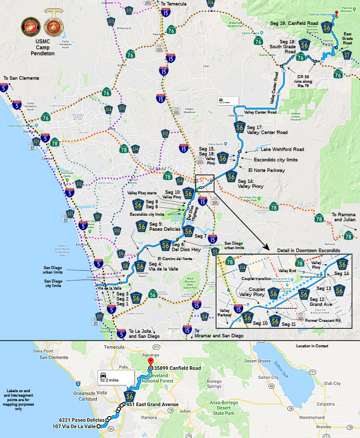 Via de la Valle from Old Highway 101 (County Sign Route S21) to the San Diego city limits (FAU, 0.76 mi)
Via de la Valle in San Diego from the San Diego city limits to the San Diego urban limits (FAU, 1.59 mi)
Via de la Valle in San Diego from the San Diego urban limits to the San Diego city limits (FAS, 0.38 mi)
Via de la Valle from the San Diego city limits to Paseo Delicias (FAS, 3.09 mi)
Paseo Delicias from Via de la Valle to El Camino del Norte (FAS, 1.30 mi)
Del Dios Highway from El Camino del Norte to the San Diego urban limits (FAS, 3.25 mi)
Del Dios Highway from the San Diego urban limits to the Escondido city limits (FAU, 3.99 mi)
Del Dios Highway in Escondido (FAU, 0.41 mi)
Del Dios Highway from the Escondido city limits to Valley Parkway (FAU, 0.20 mi)
Valley Parkway in Escondido from Del Dios Highway to the start of
the Valley Parkway/Grand Ave couplet Crescent Road
(FAU, 1.39 mi)
Note: It appears that before the city of Escondido made Valley Parkway one-way in downtown Escondido, Crescent Road ran from its current split-point off Grand to 2nd up to Valley Parkway, permitting a traditional Valley Parkway to Crescent to Grand routing. That was since reconfigured to have Valley Parkway be one way SB/WB, Grand Ave bidirectional in the center, and 2nd one-way NB/EB. The definition has S6 along Grand; Google shows S6 along Valley, and there is no designation on 2nd.
Valley Parkway/Grand Avenue couplet split Crescent Road
in Escondido from Valley Parkway to Grand Avenue (FAU, 0.22 mi)
Grand Avenue in Escondido from the Valley Parkway split Crescent
Road to Valley Blvd (FAU, 0.98 mi).
Note: Valley Parkway parallel to this may also be part of County Sign Route S6 as a couplet.
Valley Blvd in Escondido from Grand Avenue to Valley Parkway (FAU, 0.09 mi)
Valley Parkway in Escondido from Valley Blvd to Washington Avenue
El Norte Parkway (FAU, 3.07 mi)
Valley Parkway from El Norte Parkway Washington Avenue
to the Escondido city limits (FAS, 0.67 mi)
Valley Parkway in Escondido from the Escondido city limits to Lake Wohlford Road (FAS, 0.10 mi)
Valley Center Road from Lake Wohlford Road to Route 76 (FAS, 13.98 mi)
South Grade Road from Route 76 to East Grade Road (FAS, 5.30 mi)
Canfield Road from East Grade Road to the Palomar Observatory (FAS, 4.02 mi)
 History and Signage Information
This route was defined in 1959. Portions of this route may have been signed as US 101 and Business Route 5.
 Status
Total mileage: 44.79 mi.
© 1996-2020 Daniel P. Faigin.
Maintained by: Daniel P. Faigin
<webmaster@cahighways.org>.
 CR S5
CR S5 CR S7
CR S7