
 California Highways:
[Click here for a key to the symbols used. Some county routes were constructed with federal funds. These routes are indicated as FAP (Federal Aid Primary), FAU (Federal Aid Urban), or FAS (Federal Aid Secondary). If no funding source is shown, no federal funds were used. Note that while some segments seem to have the same attributes, they may differ in the county-local road number assigned to the segment, or in the Caltrans Map Sheet number.]
 Routing
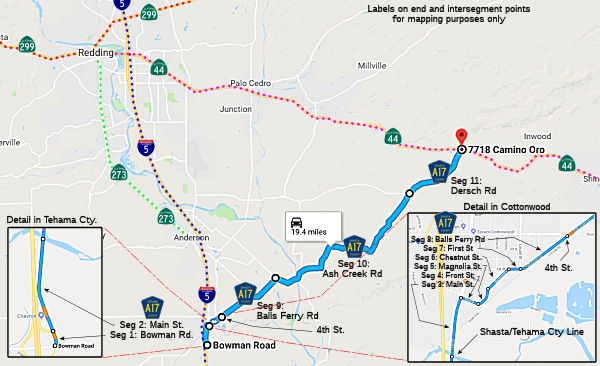 Bowman Road from I-5 to Riverlakes Ranch (FAS, 0.27 mi) [Tehama County]. Note:
"Riverlakes Ranch" appears to refer to the "River Lakes Ranch Subdivision"
in Tehama County, entered from Lake California Drive.
Bowman Road from I-5 to Riverlakes Ranch (FAS, 0.27 mi) [Tehama County]. Note:
"Riverlakes Ranch" appears to refer to the "River Lakes Ranch Subdivision"
in Tehama County, entered from Lake California Drive.
Main Street from Riverlakes Ranch to the Shasta county line (0.45 mi) [Tehama County]
Main Street from the Tehama county line to Front Street (0.43 mi) [Shasta County]
Front Street from Main Street to Pine Street (0.15 mi) [Shasta County]
Magnolia Street from Pine Street to Chestnut Street (0.11 mi) [Shasta County]
Chestnut Street from Magnolia Street to First Street (0.21 mi) [Shasta County]
First Street from Chestnut Street to Balls Ferry Road (0.10 mi) [Shasta County]
Balls Ferry Road from First Street to Fourth Street (0.43 mi) [Shasta County]
Balls Ferry Road from Fourth Street to Ash Creek Road (FAS, 3.62 mi) [Shasta County]
Ash Creek Road from Balls Ferry Road to Dersch Road (9.92 mi) [Shasta County]
Dersch Road from Ash Creek Road to Route 44 (FAS, 3.50 mi) [Shasta County]
 History and Signage Information
This route was defined in 1963.
 Status
Total mileage: 19.19 mi.
© 1996-2020 Daniel P. Faigin.
Maintained by: Daniel P. Faigin
<webmaster@cahighways.org>.
 CR A16
 CR A18