
 California Highways:
 The official state definition of El Camino Real is as follows (per AB 1707, Chapter 739, 10/12/2001):
State highway routes embracing portions of I-280, Route 82, Route 238, US 101, I-5, Route 72, Route 12, Route 37, Route 121, Route 87, Route 162, Route 185, Route 92, and Route 123 and connecting city streets and county roads thereto, and extending in a continuous route from Sonoma southerly to the international border and near the route historically known as El Camino Real shall be known and designated as "El Camino Real."
The pre-AB 1707 definition (established by Assembly Bill 1769, Chapter 1569, in 1959) was:
State highway routes embracing portions of I-280, Route 82, US 101, I-5,and Route 72, and connecting city streets and county roads thereto, and extending in a continuous route from San Francisco southerly to the international border and near the route historically known as El Camino Real are known and designated as "El Camino Real."
Note that there are other routes that are part of El Camino Real, most significantly San Diego County Sign Route S11.
![[History]](images/history.gif) Highway History
Highway History![[El Camino Map]](images/elcaminomap.gif) Note: KCET has a very nice "LA as Subject" piece on El Camino Real.
Note: KCET has a very nice "LA as Subject" piece on El Camino Real.
The legend of El Camino Real and its bells, is quite interesting. At the same time that the American colonies were rebelling against England, a coalition of Spaniards and Mexicans established outposts up the California coast. The land and sea expedition consisted of 64 men and 200 animals. This was a military campaign to expel the Jesuits, yet secure Nueva California and extend New Spain. The earliest and primary missions (and the presidios) were near good natural seaports like San Diego and Monterey Bay. Finding no metalworking among the natives, the emphasis of the campaign and future settlement of California became the conversion of the native population.The first mission was established in 1769 at San Diego, when they established a fortress and a Franciscan mission. A footpath, called The El Camino Real, or Kings Highway, was created to connect the outputs. Each outpost, called a Mission, was situated in areas where large populations of Indians lived and where the soil was fertile enough to sustain a settlement. Missions were primarily the church and agricultural center for interaction with the natives. As time progressed and more Missions were built, the footpath became a roadway wide enough to accommodate horses and wagons. Also constructed were presidios, which were military fort and seats of government, and pueblos, which were more permanent Hispanic settlements for civilians -- primarily Spanish citizens and retired military. It was not, however, until the last Mission in Sonoma was completed in 1823, that this little pathway became a real route. From that point, a series of small self-reliant religious missions were established. Each was a day's travel apart and linked by El Camino Real, Overall, El Camino Real ("The King's Highway") linked 21 missions, pueblos and four presidios from San Diego to Sonoma. These missions, pueblos, and presidos include the following (these are in the order of the map to the right, from top to bottom):
As I noted, this is a "legend". The KCET piece on El Camino Real notes that message implied by the formal "El Camino Real" (i.e., that the route is exactly the same one that the missionaries used) is largely a myth imagined by regional boosters and early automotive tourists. The route of the actual El Camino Real that helped link the presidios (military forts), pueblos (civilian towns), and religious missions was not fixed; the actual path changed over time as weather, mode of travel, and even the tides dictated. Furthermore, while the road provided local transportation links between colonial settlements, the primitive highway was eclipsed in importance by a water route between Southern and Northern California. Further, although local segments of El Camino Real were still heavily used, the route as a whole had faded into obscurity.
El Camino Real started in San Diego, in what is now Presidio Park, near the current SE corner of Taylor St. and Presidio Drive in San Diego (see California Historic Landmark #67). Over time, the original El Camino Real routing was replaced by modern highways, primarily US 101. US 101, overtime, has also been replaced in portions by I-5, Route 72, Route 82, and I-280. From Los Angeles El Camino Real leads to Hollywood, through Cahuenga Pass to Sherman Way thence to Mission San Fernandor from Sherman Way to Calabasas, Camarillo, Ventura, Santa Barbara, Gaviota, Mission Santa Ines, Mission La Purisima, Los Olivos, Santa Maria, San Luis Obispo, Paso Robles, San Miguel, Jolon, Mission San Antonio, Soledad, Salinas to Monterey and Mission Carmel, or from Salinas to Mission San Juan Bautista, San Jose, Mission San Jose, Hayward, San Leandro, to Oakland from San Jose to Santa Clara, Palo Alto, Redwood City, San Mateo, Colma, Ocean View, to Mission de los Dolores and San Francisco (Market and Third Streets). Across the bay, El Camino Real leads from San Rafael to Mission San Francisco Solano in Sonoma.
![[Image of 101 Bell from Casey Cooper's site]](images/101-bell_small.jpg) The notion of preserving El Camino Real was first
proposed by Miss Anna Pitcher, Director of the Pasadena Art Exhibition
Association to the Women's Club of Los Angeles in 1892. The factors
driving the preservation were, first, the rise of the automobile, which
created a small but influential group of wealthy Californians who clamored
for a well-maintained state highway. The second factor was a
reinterpretation of Spanish colonial California as a romantic paradise,
fueled by the 1884 publication of Helen Hunt Jackson's "Ramona" and set
within a broader cultural embrace of Southern California as a American
Mediterranean retreat. Regional boosters saw California's missions -- some
of which still functioned as parish churches, but many of them
long-neglected and crumbling into ruin -- as a place where tourists could
commune with California's romantic past from the comfort of their modern
machines. These boosters invented sentimental stories about Franciscan
fathers traveling along the road from mission to mission, which were
supposedly spaced one day apart along the trail.
The notion of preserving El Camino Real was first
proposed by Miss Anna Pitcher, Director of the Pasadena Art Exhibition
Association to the Women's Club of Los Angeles in 1892. The factors
driving the preservation were, first, the rise of the automobile, which
created a small but influential group of wealthy Californians who clamored
for a well-maintained state highway. The second factor was a
reinterpretation of Spanish colonial California as a romantic paradise,
fueled by the 1884 publication of Helen Hunt Jackson's "Ramona" and set
within a broader cultural embrace of Southern California as a American
Mediterranean retreat. Regional boosters saw California's missions -- some
of which still functioned as parish churches, but many of them
long-neglected and crumbling into ruin -- as a place where tourists could
commune with California's romantic past from the comfort of their modern
machines. These boosters invented sentimental stories about Franciscan
fathers traveling along the road from mission to mission, which were
supposedly spaced one day apart along the trail.
Unsuccessful, she tried again with a pitch to the California Federation
of Woman's Clubs (CFWC) in May 1902 and to the Native Daughters of the
Golden West (NDGW) in June 1902. Both organizations endorsed the idea.
However, in 1902 Pitcher became ill. She discussed her vision with a
friend named Harrye Rebecca Piper Forbes, who was happy to run with the
project. Forbes spent the ensuing years marking specific locations along
El Camino Real.
(Partial source: RWCPulse, "Blog: For Whom the El Camino Real Bell Signs Toll", 10/7/2022)
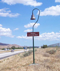
The CFWC (principally Mrs. A.S.C. Forbes and Mrs. Caroline Olney) and the NDGW eventually implemented the proposal. In 1904, a group was formed called the El Camino Real Association. This group had the mission to mark the historical route, promote tourism along the road, and lobby for government support. The actual, historical route -- which had shifted many times, in any case -- often evaded the association's trackers. Mrs. Forbes' (upon a suggestion by Mrs. C.F. Gates) created a marker that was a cast iron bell hung from an eleven-foot bent guidepost. The first bell was placed in 1906 in front of the Old Plaza Church in downtown Los Angeles. Eventually, there were approx. 158 bells installed along the Camino Real by 1915 (AAA states the number is closer to 400). The bell marker was fashioned after those at Los Angeles' Plaza Church, and hung from a pole resembling a shepherd's staff. The markers were the design of Forbes, who with her husband owned the only bell foundry west of the Mississippi.
Alas, the bells were not maintained, and by 1926, the bells had fallen into disrepair and some had been stolen. From 1926 to 1931, the California State Automobile Association and the Automobile Club of Southern California assumed responsibility for maintenance and replacement of bells on state-owned property (just as they had responsibility for signage). In fact, the bells often served as highway signage, working as markers for California motorists. By 1949, there were approx. 286 bells along the road.
The roadway itself fell short of expectations at first. While the 1910 State Highways Act authorized construction of a paved road along the route of El Camino Real, construction lagged and for many years much of the historic road was only a primitive trail. Between cities there were streams to ford and steep grades to scale. Sometimes, teams of horses would rescue automobiles trapped in mud. Finally, by the mid-1920s, the highway construction was complete, and in 1925 the route was signed as US 101.
In 1960, Justin Kramer of Los Angeles won the bid to manufacture replacement bells. His design became the standard. Theft and vandalism continued to take its toll, and the number dwindled to about 75.
In 1974 the Legislature appointed Caltrans as guardian of the bells, responsible for repairing or replacing them. Replacements are made of concrete, rather than cast iron, to discourage theft. Along with Los Angeles County, the bells are located in the counties of Ventura, San Benito, Monterey, San Luis Obispo, Santa Barbara, San Mateo and Santa Clara. In 1996, Caltrans developed the "Adopt-A-Bell" program (specifically, it was developed by Keith Robinson, who was the Statewide Coordinator of the Caltrans Adopt-A-Highway Program because he had an interest in El Camino Real and the loss of the mission bell markers; it appeared to him to be a good way to get the bell markers back on the highways for the public to recognize the historic route of El Camino Real). After the program was conceived, the California Federation of Womens Clubs was offered the opportunity to adopt as many bells as they could until early 1998. The adoption guidelines were written so that after early 1998 anyone could adopt a bell and maintain it under the Adopt-A-Highway Program.
Up until 2006, the CFWC continued to work to place more bells on El Camino Real in California. Also working on the program were the Automobile Clubs of Northern and Southern California, the Knights of Columbus, The California Sister Cities Program and Various sites in Baja California. In October of 1997, a special bell was erected at Loreto, Baja California Sur, the site of the very first successful mission to be established in the Californias, thus marking the site of the very beginning of El Camino Real. In June of 1998, the California State Dept. of Transportation and the Mexican National Institute of Anthropology and History, in conjuction with CFWC and The Knights of Columbus, dedicated a bell on the international border at the San Ysidro/Tijuana crossing.
 In 2000, Keith Robinson, Principal Landscape Architect,
Landscape Architecture Program Division of Design of Caltrans applied for
and received a federal grant in 2000 to restore El Camino Real Mission
bell marker system on the state highways. This grant allowed Caltrans to
install bells every one to two miles along El Camino Real from San
Francisco through Orange County. San Diego County was not included in the
grant as El Camino Real is not on the state highway system within the
county. The bells, manufactured by California Bell, were cast from a mold made from one of the original bells installed before 1910, they are an exact copy of the original bells,
unlike the bells installed on or near El Camino Real by the CFWC and
others. As of July 2004, 370 new bells have been erected in San Benito,
Monterey, San Luis Obispo and Santa Barbara Counties. Two additional
contracts were in Los Angeles & Ventura Counties (115 bells are being
installed) and San Mateo & Santa Clara Counties (70 bells are being
installed). All told, 555 new bells will have been added to the El Camino
Real Mission Bell Marker System -- the installation was completed in June
2006, just in time for the 100th anniversary of the installation of the
original bell in 1906. The bells are placed on both sides of the highway
at approximately 1-2 mile intervals. In locations where Caltrans could not
find a safe place to install the bells they were not erected - creating a
longer gap between bells. The picture (taken by SLO Richards, and used
with permission) shows the a new bell, installed on Route 101 near Camp
Roberts. The first bell for the contract was placed in Monterey County
just North of Salinas along Southbound US 101.
In 2000, Keith Robinson, Principal Landscape Architect,
Landscape Architecture Program Division of Design of Caltrans applied for
and received a federal grant in 2000 to restore El Camino Real Mission
bell marker system on the state highways. This grant allowed Caltrans to
install bells every one to two miles along El Camino Real from San
Francisco through Orange County. San Diego County was not included in the
grant as El Camino Real is not on the state highway system within the
county. The bells, manufactured by California Bell, were cast from a mold made from one of the original bells installed before 1910, they are an exact copy of the original bells,
unlike the bells installed on or near El Camino Real by the CFWC and
others. As of July 2004, 370 new bells have been erected in San Benito,
Monterey, San Luis Obispo and Santa Barbara Counties. Two additional
contracts were in Los Angeles & Ventura Counties (115 bells are being
installed) and San Mateo & Santa Clara Counties (70 bells are being
installed). All told, 555 new bells will have been added to the El Camino
Real Mission Bell Marker System -- the installation was completed in June
2006, just in time for the 100th anniversary of the installation of the
original bell in 1906. The bells are placed on both sides of the highway
at approximately 1-2 mile intervals. In locations where Caltrans could not
find a safe place to install the bells they were not erected - creating a
longer gap between bells. The picture (taken by SLO Richards, and used
with permission) shows the a new bell, installed on Route 101 near Camp
Roberts. The first bell for the contract was placed in Monterey County
just North of Salinas along Southbound US 101.
In June 2011, the CTC approved $161,000 to make and install 40 Mission Bell markers along US 101 in the Santa Rosa and Rohnert Park areas and on Route 12 near Sonoma.
In May 2012, it was reported that even the new bells are the subject of
theft. Mission bells along Highway 101 at Seaward Avenue, Telephone Road
and Main Street in Ventura were reported stolen in Apri 2012. Measuring 18
inches in diameter and usually weighing 85 pounds, the bells are mounted
on 15-foot-tall posts attached to concrete foundations. The stolen bells
cost about $2,700 each to make and will be replaced.
(Source: Ventura County Star)
The Facebook Group California Roads, Signs, and Maps: A Collection of Old & New is maintaining a crowd-sourced map of the location of all the bells.
In June 2019, it was reported that the ECR bell at UC Santa Cruz was
removed. It was moved in representation of the fact that for local tribal
leaders, such as Valentin Lopez, those bells represent unimaginable
suffering and destruction. Lopez has been campaigning for the removal of
mission bells for years, and spent the past year in discussion with campus
leaders over the removal of this particular bell. The Santa Cruz bell
removal comes during a period of larger reckoning around
California’s blood-soaked treatment of its native people. In June
2019, Gov. Gavin Newsom took the rare step of issuing an executive order
apologizing on behalf of the citizens of California for a history of
“violence, maltreatment and neglect” against Native Americans.
Boosters, real-estate developers and automobile associations alike used a
romanticized Spanish past to sell modern Southern California into being.
But much of what they were shilling was fiction. For instance, the entire
idea of California having a singular El Camino Real that ran like a
central artery through the state — connecting the 21 missions and
acting as a path for the Franciscan friars — is a 20th century
reinvention. Yes, there were missions and ways to get from one to the
next, but the nostalgic notion of a single camino is “a fiction
created in the 20th century to promote automobile tourism up and down the
coast of California,” as UC Riverside history professor Steven
Hackel explained to KCET a few years ago. The roadside mission bell
markers you’ve seen on the highway emerged through the work of a
local activist, backed by the Auto Club. California’s car culture
and the reinvented history of the El Camino Real rose in tandem, as the
state drew early automobile tourists and fed them a delectable revisionist
history, conveniently divided into easy day trips. Caltrans embarked on a
project to restore the original highway marker bells in 1997 and received
two federal grants totaling nearly $2 million to complete the project.
There are about 585 mission bell markers, placed about one to two miles
apart. The university’s vice chancellor of business and
administrative services, Sarah Latham, said the decision to remove the
bell came after outreach attempts this past academic year. The school
listened to members of the Amah Mutsun Tribal Band as well as students and
community members about what the bell meant to them, she said. The
university ultimately moved forward with the removal “in support of
efforts to be more inclusive,” Latham said. The Amah Mutsun
identified two acceptable options for the disposal of the bell: placing it
in a museum with proper historical context or melting it down. The
university hasn’t yet decided on the bell’s fate, but it will
“do more outreach” to find the best solution, Latham said. The
bell was placed on the campus in the 1990s and was a copy of the original
mission bells.
(Source: LA Times, 6/21/2019; PressDemocrat,
6/22/2019)
After the removal of the bells on the UCSC campus, the Amah Mutson turned
their attention to the city of Santa Cruz. They met with Mayor Martine
Watkins in August 2019, and later the City Council, to request the removal
of two more bells in the city of Santa Cruz, following the removal of the
first mission bell on UCSC campus in June. The Amah Mutsun say that the
bells, like Confederate monuments in other parts of the country, are
presented as benign historical markers but are in fact deeply political
symbols which shape public perception, enshrining distorted visions of the
past and obscuring historic crimes. The two remaining bells in Santa Cruz
are at the Mission Plaza on Mission and Sylvar Streets and at the corner
of Soquel Avenue and Dakota Street. The Amah Mutsun Tribal Band is
focusing on removing bells within their tribal boundaries, hoping to
achieve a domino effect on the removal of bells in surrounding areas such
as Monterey, which lies outside their traditional territory just north of
the Salinas River. The Amah Mutsun Tribal Band, collectively referred to
by many as Ohlone, are the indigenous peoples of territories ranging from
Año Nuevo to the northern half of Monterey Bay and the San Juan
Valley. The traditional territory of the Amah Mutsun encompasses all or
portions of the modern counties of San Benito, Monterey, Santa Cruz, Santa
Clara and San Mateo. The tribe historically consisted of 20 politically
distinct communities that shared cultural practices and tribal traditions
as its members occupied the San Juan Valley for thousands of years before
the arrival of the Spanish in the 1700s. The Spanish began their
colonization of Central California in 1770 when Father Junipero Serra
founded Carmel Mission, the second of 21 missions stretching up the coast
from San Diego to Sonoma, each within a day’s ride of the next one.
The modern tribe consists of the descendents of indigenous people who
survived Missions San Juan Bautista (Mutsun) and Santa Cruz (Awaswas)
during the late 18th, 19th and early 20th centuries.
(Source: Voices of Monterey Bay, 8/8/2019)
In August 2021, it was reported that an event was held where the last
standing 'El Camino Real' mission bell marker in downtown Santa Cruz was
to be removed. On Aug. 28, the Amah Mutsun Tribal Band joined with the
city of Santa Cruz and a crowd of around 100 spectators to remove the last
of three El Camino Real bells on public property in that city. The bell,
located at Soquel and Dakota avenues, was to be removed with the
city’s approval, following a November 2020 recommendation by the
Santa Cruz Historic Resources Commission. The bell, however, was removed
illegally by vandals just hours before the gathering. The Santa Cruz
Police Department is conducting an investigation. The City of Santa Cruz
has unanimously resolved to remove all El Camino Real bell markers from
public property, following requests by the Amah Mutsun Tribal
Band—and will now become the first city in California to do so. Two
other bells in the city have previously been removed, both in June 2019.
The first was on the UC-Santa Cruz campus and taken down by officials
there. The second, in Mission Park Plaza, was stolen during a protest on
June 11. The Amah Mutsun are calling for the statewide removal of El
Camino Real bell markers and all other monuments that attempt to glorify
and celebrate the domination, dehumanization and erasure of the Indigenous
people of California. Mission bells symbolize the enslavement of
Indigenous people in the California Mission system. The El Camino Real
bell markers were created in the early 1900s to promote automobile tourism
and visitation of the missions and to celebrate a white-washed,
romanticized and distorted history. The bell will be replaced immediately
with an informational metal sign that will describe the reasons for the
bell’s removal. That sign will eventually be replaced by a permanent
plaque or memorial which will be developed by the Amah Mutsun in
coordination with the City of Santa Cruz. The traditional land of the Amah
Mutsun covered areas of San Benito, Monterey, Santa Cruz, Santa Clara and
San Mateo counties.
(Source: Irenita Xirenita on FB, 8/15/2021; Remove The El Camino Real Bells, retrieved 9/4/2021; BenitoLink, 8/31/2021)
However, the goal of removing all the bells would be difficult. Caltrans
continues to install the bells, having ordered over 550 of them from
California Bell since 2000. According to the California Bell website,
there are about 585 bells currently in place along Hwy. 101. California
Bell has produced over 5,500 mission bells for use by churches,
institutions and private individuals around the world since the current
owner bought the business in 2000.
(Source: BenitoLink, 8/31/2021)
![[Links]](images/links.gif) Related Links
Related LinksThere is also excellent information in the book California's El Camino Real and Its Historic Bells by Max Kurillo and Erline Tuttle (Sunbelt Publications).
California cannot lay claim to the only El Camino Real. Some other significant El Camino Reals include:
 De Anza Trail
  Return to Trails and Roads Home
© 1996-2020 Daniel P.
Faigin.
Maintained by: Daniel P. Faigin <webmaster@cahighways.org>.