

 Last Sunday was the third installment of my Skirball class on the Sepulveda Pass (#1, #2). I thought I would take a little time while I eat my lunch to share what I remember with you. The focus of this class was the San Diego Freeway, and the instructor was basing much of his material on the seminal book by David Brodsly.
Oh, and before you say it… yes, the instructor had to ask me not to interject a lot during this session. Yes, he had to ask me more than once 🙂
The session started out by exploring the place of the freeway in shaping Los Angeles. He started by showing some videos about Carmageddon, including the famous Hitler Carmageddon video. He did this to emphasize the 405‘s current role as a vital traffic artery.
He then emphasized this by noting how we orient with freeways. As an example of this, ask a native Angeleno to draw a map of the city. What is the first thing they draw for reference: the freeways. LA is not shaped by its natural landmarks; in fact, without the freeway system on a map, it is difficult for people to orient themselves. As part of this exercise, the instructor handed out a map of Southern California with just the major freeways on it, and asked people to identify whatever else they wanted. The resulting maps varied greatly, based on people’s interest and where they lived. One guy drew mostly railroads. Me? More streets, more highways, and more communities. The exercise reminded me of something in Brodsly’s book — a series of maps that showed chronotherms — that is, a series of circles that represented 10 minutes away, 20 minutes away, etc., and how that changed over time.
Next, the instructor explored how the freeway system came to Los Angeles. He talked about the traffic problems that were present with the introduction of the automobile, and some of the earliest traffic studies — the 1924 Major Traffic Street Plan. He noted how this called for a series of traffic separations by purpose — parkways for people; and commercial routes for trucks. He then talked about the Auto Club traffic survey in 1937, and its recommendation of a series of controlled access parkways. In this discussion, he noted that the primary role of the Auto Club was to … sell insurance. I added a clarification here that the Auto Club was also primarily responsible for signage of highways until the 1950s in both parts of the state, including posting highway numbers. I didn’t mention that the Auto Club was not originally insurance; the original incarnation grew out of the good roads movement and later moved into services to benefit the motorist… such as insurance and maps. [Note: as a plug here, looking at my maps page would be useful]
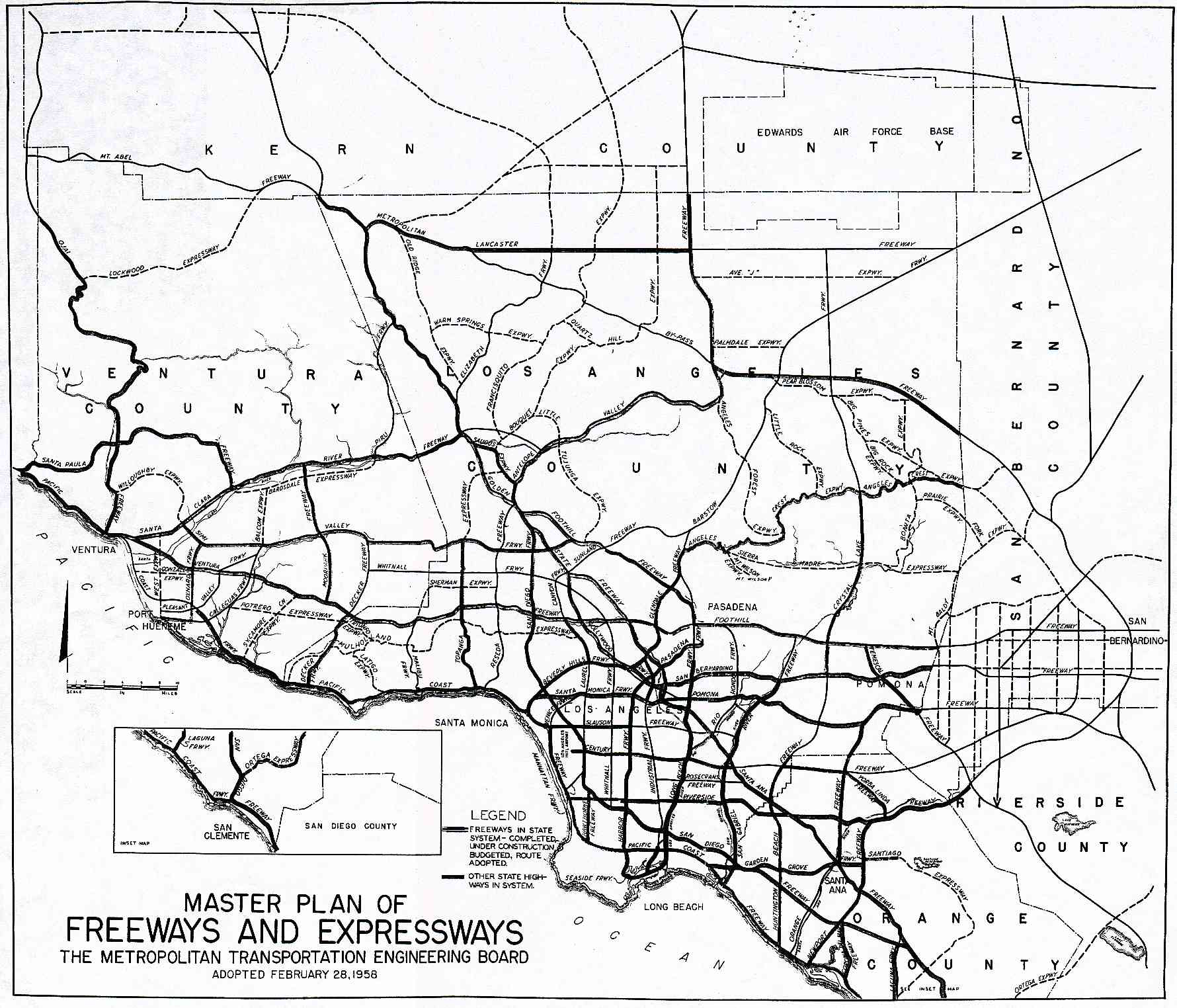
He next discussed the start of the Interstate system, including the usual stories about Eisenhower’s cross-country trip and his experiences in Germany. I pointed out there that much of the story is urban legend, and recommended he read “The Big Road” by Earl Swift, which provides a good discussion of the creation of the Interstate system. In this discussion, he used the 1956 Metropolitan Transportation Engineering Board planning map from my site. He talked briefly about some of the planned freeways that were never constructed (I added some more clarifications here :-)), and then focused in on the Beverly Hills Freeway. In particular, he talked about the protests that killed the BH Freeway (Route 2), mostly led by the rich establishment in Beverly Hills and Bel Air (much of this same establishment are the folks protesting the Metro extension under Beverly Hills HS)*. He wondered why there were not similar protests for the San Diego Freeway, which also went through rich neighborhoods. The answer, he opined, was that (a) these rich communities weren’t there at the time the route was selected and construction began (late 1950s), and (b) there was such a tremendous need for the route given the lack of alternatives and the capacity limitations of the existing road.
[*: Researching this, I discovered that both Jan Perry and Kevin James are against the subway going under Beverly Hills; this may make me reconsider my vote later today.]
He then talked about the San Diego Freeway itself — how much earth was moved during construction and such. More importantly, he talked about how the creation of the freeway made the crest of the hill a viable location for institutions, which leads to the story of the Jewish institutions on the hill… which will be the next class.
For me, there was a lot that should have been discussed and wasn’t. I might have also brought up the 1963 state highway map, for example. But even more so, I would have liked to have learned more about the history of the route itself. How did the city or county identify the need for a road over Sepulveda Pass, and in what order were the various canyon roads (Topanga, Laurel, Coldwater, Beverly Glen) constructed. Are there any interesting nuggets in the studies? [This information should all be in the city or county public works department, if not the Auto Club). As for the freeway, there are usually a number of alternatives considered, even in the days before EIRs. It would be interesting to see what alternatives were considered and some of the engineering tradeoffs. It would also have been useful for him to talk about some of the future plans (although I filled folks in on this).
Oh, lunch is over. Time to get back to work.
Music: Hot (Squirrel Nut Zippers): “Twilight”
