
 California Highways:
Click here for a key to the symbols used. An explanation of acronyms may be found at the bottom of the page.
 Routing
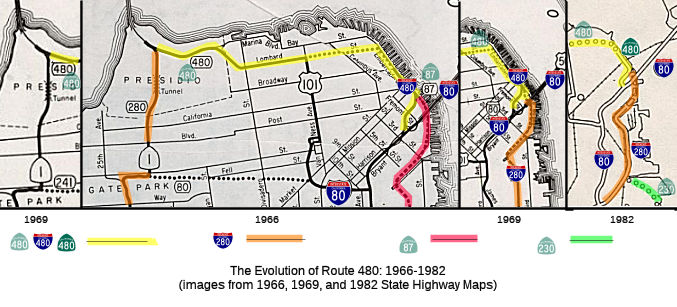 Nocurrent
routing.
Nocurrent
routing.
 Post 1964 Signage History
In 1963, Route 480 was defined as "Route 80 at the San Francisco-Oakland Bay Bridge approach in San Francisco to the junction of Route 280, Funston approach, and the approach to the Golden Gate Bridge in the Presidio of San Francisco passing near the intersection of Lombard Street and Van Ness Avenue."
A post on AAroads provides the construction history: "The initial
construction of the Embarcadero Freeway in San Francisco began in mid 1955
from the Bay Bridge - San Francisco Skyway (I-80, then US 40/US 50) just
past 4th St. to about 1st St. It then was extended to above Beale St.,
with on/off ramps at Mission St. between Beale and Main Sts., opening in
January, 1957. Construction of the main portion along the Embarcadero was
delayed for several months during 1956, but picked up again in early 1957,
with construction commencing at both ends (above Beale St. and from
Broadway at Sansome Streets.). The main building of the structure above
the Embarcadero went on through 1957 to early 1959, and the entire
structure was completed in April 1959. Later, in 1965, an on/off ramp was
added connecting to Front St. at Clay and Washington Streets. - this
opened in Aug., 1965."
(Source: Northcoast707 on AAroads, 5/17/2019)
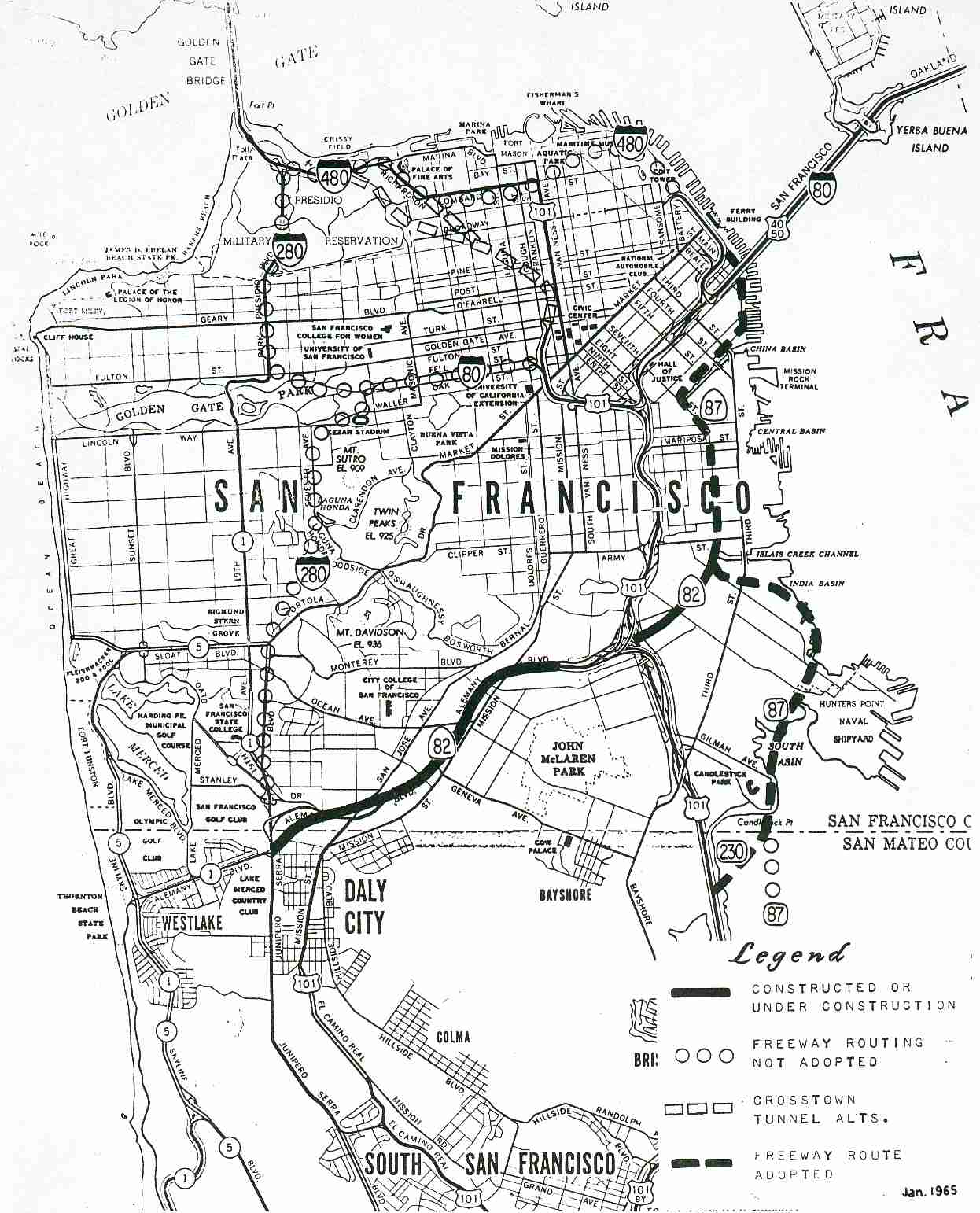
In March 1965, the California Division of Highways issued a report in
response to the resolutions by the San Francisco Board of Supervisors, and
resolutions by the California Highway Commission. This report explored a
variety of potential routes fro the E/W segment of proposed Route 480
between the Embarcadero and the Golden Gate Bridge. Other studies were on
hold until San Francisco adopted a trafficways plan for the city. The
report noted that "The section of Interstate Highway Route 480 considered
in this report is between the present northerly terminus of Route 480 near
Broadway and the Golden Gate Bridge approach in the Presidio. It could
traverse portions of the North Waterfront, Telegraph Hill, Fisherman's
Wharf, North Beach, Russian Hill, Fort Mason, Cow Hollow, and Marina
Districts. This project contemplates no change in the
presently-constructed section of Route 480 along the Embarcadero." A
tunnel was considered, but as the report notes "The material in Telegraph
ar\d Russian Hills is composed of severely shattered and sheared rock,
sandstone and shale. Extreme care during construction of bored tunnels
could minimize the risk of, but probably not prevent, surface settlement
and the accompanying damage to existing surface structures. The
unprecedented size of the tunnel bore - 72 feet clear for four-lane
sections - and the subsurface conditions create critical engineering
problems. Among these are construction of temporary tunnel supports,
handling of high footing pressures due to tunnel size, and lowering of the
existing watertable and handling interference with substructures of
existing buildings."
(Source: San Francisco Golden Gate Freeway Interstate Highway Route 480 Technical Report, March 1965)
 The March 1965 report explored a number of alternatives. The report notes that the 1963
legislative description provides that the route runs from the San
Francisco-Oakland Bay Bridge approach to the Funston approach to the
Golden Gate Bridge, "passing near the intersection of Lombard Street and
Van Ness Avenue." The report notes that "Alternatives G and FJG most
nearly fit this description . Alternative GHF most nearly fits the route
suggested in Board of Supervisors' Resolution No. 605-63. Alternative F-1,
FJG most nearly fits the location shown on San Francisco's Trafficways
Plan. The alternatives have been divided into two basic corridors - F and
G. There are two crossover alternatives, H and J, under Russian Hill. The
F and G alternatives have been divided into easterly and westerly
segments. There are several alignment variations of Alternative F in the
North Waterfront and Marina Areas." With respect to Alternative F, the
report notes "Alternative F skirts the easterly and northerly faces of
Telegraph Hill; then lies between Bay and North Point Street from the
sewage disposal plant to Laguna Street; from which F and its westerly
variations pass through, around, or under the Marina Green and yacht
harbors to the Golden Gate Bridge approach in the Presidio. The easterly
variations of F all lie generally along or east of the Embarcadero.
Alternative F-1 retains the present structure type along the Embarcadero,
changes to single-level viaduct along BayStreet and joins the basic F near
Taylor Street. This route conforms to the location shown on San
Francisco's current Trafficways Plan. Two other alternatives in the
Embarcadero area, Alternatives F-2 and F-3, are discussed under Other
Routes Studied. These alternatives would not be practical unless radical
and rapid change takes place in the North Waterfront Area. All F
alternatives would permit the extension of the Fisherman's Wharf cable car
line north of North Point Street. A proposal of this kind is now under
consideration by the San Francisco Board of Supervisors." With respect to
Alternative G, the report notes "The G alternative with its long tunnels
and depressed grade line with the surface street cantilevered over the
eastbound lanes along Greenwich Street results in an inconspicuous
freeway. The opportunity for joint use of rights of way occurs only at
tunnel portals and along Greenwich Street and Columbus Avenue. The
motorist's visual perspective is seriously limited by confinement in the
long tunnels and the partially covered depressed section." On the W side,
it notes "This alternative curves westerly, passes under Telegraph Hill in
bored tunnel, is in an open depressed section between Powell and Taylor
Streets , then passes under Russian Hill in a bored tunnel. The primary
disadvantages of this alternative are that it is inordinately expensive,
involves construction risks, will have high maintenance and surveillance
costs, and will confine the motorist in a mile of tunnel. The only
advantage this alternative provides is that of keeping the freeway almost
entirely out of view of San Franciscans." Based on the 1968 map, it looks
like the Highway Commission went with one of the Route F variations.
The March 1965 report explored a number of alternatives. The report notes that the 1963
legislative description provides that the route runs from the San
Francisco-Oakland Bay Bridge approach to the Funston approach to the
Golden Gate Bridge, "passing near the intersection of Lombard Street and
Van Ness Avenue." The report notes that "Alternatives G and FJG most
nearly fit this description . Alternative GHF most nearly fits the route
suggested in Board of Supervisors' Resolution No. 605-63. Alternative F-1,
FJG most nearly fits the location shown on San Francisco's Trafficways
Plan. The alternatives have been divided into two basic corridors - F and
G. There are two crossover alternatives, H and J, under Russian Hill. The
F and G alternatives have been divided into easterly and westerly
segments. There are several alignment variations of Alternative F in the
North Waterfront and Marina Areas." With respect to Alternative F, the
report notes "Alternative F skirts the easterly and northerly faces of
Telegraph Hill; then lies between Bay and North Point Street from the
sewage disposal plant to Laguna Street; from which F and its westerly
variations pass through, around, or under the Marina Green and yacht
harbors to the Golden Gate Bridge approach in the Presidio. The easterly
variations of F all lie generally along or east of the Embarcadero.
Alternative F-1 retains the present structure type along the Embarcadero,
changes to single-level viaduct along BayStreet and joins the basic F near
Taylor Street. This route conforms to the location shown on San
Francisco's current Trafficways Plan. Two other alternatives in the
Embarcadero area, Alternatives F-2 and F-3, are discussed under Other
Routes Studied. These alternatives would not be practical unless radical
and rapid change takes place in the North Waterfront Area. All F
alternatives would permit the extension of the Fisherman's Wharf cable car
line north of North Point Street. A proposal of this kind is now under
consideration by the San Francisco Board of Supervisors." With respect to
Alternative G, the report notes "The G alternative with its long tunnels
and depressed grade line with the surface street cantilevered over the
eastbound lanes along Greenwich Street results in an inconspicuous
freeway. The opportunity for joint use of rights of way occurs only at
tunnel portals and along Greenwich Street and Columbus Avenue. The
motorist's visual perspective is seriously limited by confinement in the
long tunnels and the partially covered depressed section." On the W side,
it notes "This alternative curves westerly, passes under Telegraph Hill in
bored tunnel, is in an open depressed section between Powell and Taylor
Streets , then passes under Russian Hill in a bored tunnel. The primary
disadvantages of this alternative are that it is inordinately expensive,
involves construction risks, will have high maintenance and surveillance
costs, and will confine the motorist in a mile of tunnel. The only
advantage this alternative provides is that of keeping the freeway almost
entirely out of view of San Franciscans." Based on the 1968 map, it looks
like the Highway Commission went with one of the Route F variations.
(Source: San Francisco Golden Gate Freeway Interstate Highway Route 480 Technical Report, March 1965)
In 1968, Chapter 282 made a number of changes reflecting the reworking of
the freeway plans in San Francisco. Two of these changes were of concern
to Route 480. First, Route 280 moved off of Park Presidio/Veterans Blvd
(signed as Route 1) to a new route (former Route 82) on the E side of
I-80. In doing so, it gained the segment of Route 87 from Route 230 to
Harrison Street (which is the street just N of I-80); the remainder of
Route 87 (from Harrison Street to Route 480) became part of Route 480.
This made the new version of Route 480: “Route 80 at the San
Francisco-Oakland Bay Bridge approach in San Francisco to the junction
of Route 280, Route 280 near Harrison Street in San
Francisco to the junction of Route 1, Funston approach, and the
approach to the Golden Gate Bridge in the Presidio of San Francisco
passing near the intersection of Lombard Street and Van Ness
Avenue.”
In 1991, SB 181, Chapter 498 deleted the remainder of Route 480, from Route 280 near Harrison Street in San Francisco to the junction of Route 1, Funston approach, and the approach to the Golden Gate Bridge. The portion from Marina Boulevard to the approach to the Golden Gate Bridge was transferred to Route 101. The last signs for the route were removed in 1997.
Why did these changes occur? In 1955, it was planned to have the US 101/I-480 interchange (and co-signing) begin approximately at the Lombard/Van Ness junction (where the Embarcadero and Central Freeways would have intersected)—this is illustrated in the 1955 Trafficways Map. By 1965, there was a new plan (which was reflected in the 1968 changes) to have a Central Freeway crosstown tunnel from Turk Street to Richardson Avenue, resulting in a much shorter multiplex of Route 480 and US 101 on Doyle Drive only—as illustrated in this 1965 Caltrans Map. This is why it was Route 480 (not US 101) on Doyle Drive (for US 101 exited on Richardson and presumably to the crosstown tunnel).
This route was intended to provide a freeway connection between the Golden Gate and Bay bridges in San Francisco. It was a double-deck roadway design. Calls for the Embarcadero Freeway’s demolition rang out even before the first stretch opened in 1959. The SF Chronicle was against the freeway from the beginning. An editorial from Nov. 22, 1955, included two photos of a huge roadway in Seattle “to show San Franciscans what a double-decker freeway looks like, so that they can intelligently calculate the aesthetic price as they debate this and future freeway construction.” After its debut, the freeway was assailed in another Chronicle editorial, this one from Aug. 28, 1959. The headline: “The boobery goes on and on.” That gem provided a clear view of the piece’s thrust: “We oppose and have consistently opposed the hideous monstrosity which the State Highway Commission built along the Embarcadero in front of the Ferry Building, obscuring the tower and the World Trade Center from view. ... Such an evil is the Embarcadero Freeway, which as we said last Friday and here repeat, should be demolished.”
The history of the construction of the Central Freeway through Hayes Valley -- and the controversy associated with it -- is discussed in "The Birth And Life Of The Freeway In Hayes Valley". This also includes a discussion of the Embarcadero Freeway.
The demolition of the freeway was put to a vote in 1986, but San Francisco voters defeated the two ballot propositions to start the tear-down. The measures lost by large margins and were major setbacks for both Mayor Dianne Feinstein and the city’s environmental groups.
On Oct. 17, 1989, the Loma Prieta earthquake struck, severely damaging
the freeway. On Jan. 10, 1990, engineers hired by the state said it would
cost between $14 million and $15 million to make the structure sturdier
than it was before the quake and that the work would take about four
months — quicker than expected. A heated discussion continued, until
finally, on Jan. 2, 1991, Caltrans engineers conceded what local leaders
had been saying all along: fixing the Embarcadero Freeway would be nearly
as expensive as rebuilding it from scratch. This renewed assessment
cleared the way for the demolition. A gigantic battering ram knocked loose
a chunk of the freeway on Feb. 27, 1991, marking the beginning of the end
for route.
(Source for some of the above: SF Chronicle, "An Ode to the Embarcadero Freeway, the Blight by the Bay", 8/1/2017)
The route, essentially, was doomed from the start, especially after January 1959 when the San Francisco Board of Supervisors Resolution 45-59 passed, which indicated opposition to certain freeway routes. Route 480 is one of the freeways opposed by the city; and was never included in the California Freeway and Expressway System, although it was briefly a part of the Interstate system.
The Embarcadero Freeway (Route 480) ran north along the waterfront for nearly a mile, 70 feet high and 52 feet wide. It started at Folsom Street and ended bluntly at Broadway, running right in front of the historic Ferry Building. The freeway was designed to make a turn inland and head west past Aquatic Park, all the way to the Golden Gate Bridge.
Several days after the 1989 Loma Prieta earthquake closed the highway,
the executive director of the California Seismic Safety Commission
inspected the freeway. There were deep diagonal cracks in half of the
pillars just below the structure’s second deck. Those who wanted to
get rid of the eyesore saw an opportunity. But neighborhood activists and
business owners from Chinatown, North Beach and Fisherman’s Wharf
worried that without a quick fix to the freeway, their businesses would be
in peril. Mayor Art Agnos stayed neutral at first, until he warmed to a
plan to replace the freeway with a sunken roadway, a project that would
take an estimated four years to complete. Business groups were alarmed
— they didn’t want to wait that long. Rose Pak, a forceful
Chinatown community leader, led the charge from that community to try to
get the freeway rebuilt quickly. Protests weren't enough — the Board
of Supervisors voted 6-5 to demolish the freeway, if federal funds could
not be found for its replacement. It wasn’t long before the plan
shifted to just getting the damaged ghost highway down as fast as possible
— and even some business groups started to agree. The demolition
crews began setting up in early 1991. The last days of the Embarcadero
Freeway “served as a giant beer garden with a spectacular
view”. Drawn by the wonderful views and easily scaleable fence, the
empty freeway became a draw for barbecues and potluck dinners, a makeshift
roller-skating track, a refuge for the homeless and a drinking spot for
all types. The demolition kickoff was a big party. A group of Ethel Merman
look-alikes sang a version of “Shake, Rattle and Roll,”
presumably in honor of the earthquake. A Dixieland band wearing hard hats
performed underneath the structure. Commemorative posters marking the
freeway’s demolition were sold for $10.
(Source: SF Chronicle "Vault", 2/6/2019)
In 1998, there were brief plans to rebuild the Embacadero Freeway as a brief cut and cover tunnel. The proposal was to only extend to roughly the point of where the elvated freeway structure was truncated.
The history of the route is fascinating; read the planning studies in the LINKS section for details. There were some plans to build it as a tube in the bay, or as a very narrow depressed highway, where there was little or no clearance to construct the road.
Some folks claim to have seen maps where I-480 looped around San Francisco after the Golden Gate Bridge, running S as the Park Presidio and Junipero Serra Freeways. This is unlikely. It is more likely that those freeways were to have been signed as part of Route 1. Note: According to Caltrans, Park-Presidio Boulevard possesses all the attributes of a freeway and was the first such thoroughfare in northern California. It was built through the Presidio of San Francisco as an approach to the Golden Gate Bridge.
 Pre 1964 Signage History
Route 480 was LRN 224, defined in 1947.
Tom Fearer provides some additional history: The Embarcadero Freeway was
planned to connect the western approach of the Bay Bridge to US 101 at
Lombard Street and Van Ness Avenue. This projected alignment of LRN 224
would have required tunneling through the massive Russian Hill on Lombard
Street to reach US 101. The projected path of the Embarcadero Freeway
first appears on the 1948 State Highway Map City Insert. On the 1958 State
Highway Map the first segment of the Embarcadero Freeway is shown
connecting from the western approach of the Bay Bridge to the Embarcadero
near Howard Street. The double decker portion of the Embarcadero Freeway
began near Fremont Street. On the 1960 State Highway Map the Embarcadeo
Freeway is shown extended to Broadway from the western approach of the Bay
Bridge. The projected path of LRN 253 appears on the State Highway Map
connecting from US 101 north to the Embarcadero Freeway underneath the Bay
Bridge. On the East Side of San Francisco Bay the planned route of LRN 257
is seen connecting the eastern approach span of the Bay Bridge.
(Source: Gribblenation Blog The Embarcadero and history of Interstate 480/California State Route 480 on the Embarcadero Freeway)
 Status
Although the route no longer exists, the Caltrans bridge log for a time indicated that the route is signed as US 101 between post mile 2.85 and post 5.48. The Fremont St. exit off I-80 W is the former CA 480 exit. There is also a sealed-off CA 480 exit off of I-80 E.
 Naming
 Interstate Submissions
 Route 480 was approved as chargeable interstate sometime pre-1965; it
was deleted as a chargeable route in August 1965 (hence, its signage after
that date with a state shield (Route 480), as opposed to an interstate
shield). The old Route 480 was demolished between 1991 and 1993.
Route 480 was approved as chargeable interstate sometime pre-1965; it
was deleted as a chargeable route in August 1965 (hence, its signage after
that date with a state shield (Route 480), as opposed to an interstate
shield). The old Route 480 was demolished between 1991 and 1993.
This route was first proposed as I-110. After 3di numbering conventions were developed, this was proposed as I-380. AASHTO finally approved it as I-480.
 Other WWW Links
 Scenic Route
[SHC 263.1] Originally, the entire route. Since deleted.
© 1996-2020 Daniel P. Faigin.
Maintained by: Daniel P. Faigin
<webmaster@cahighways.org>.
 Route 466
 Route 505
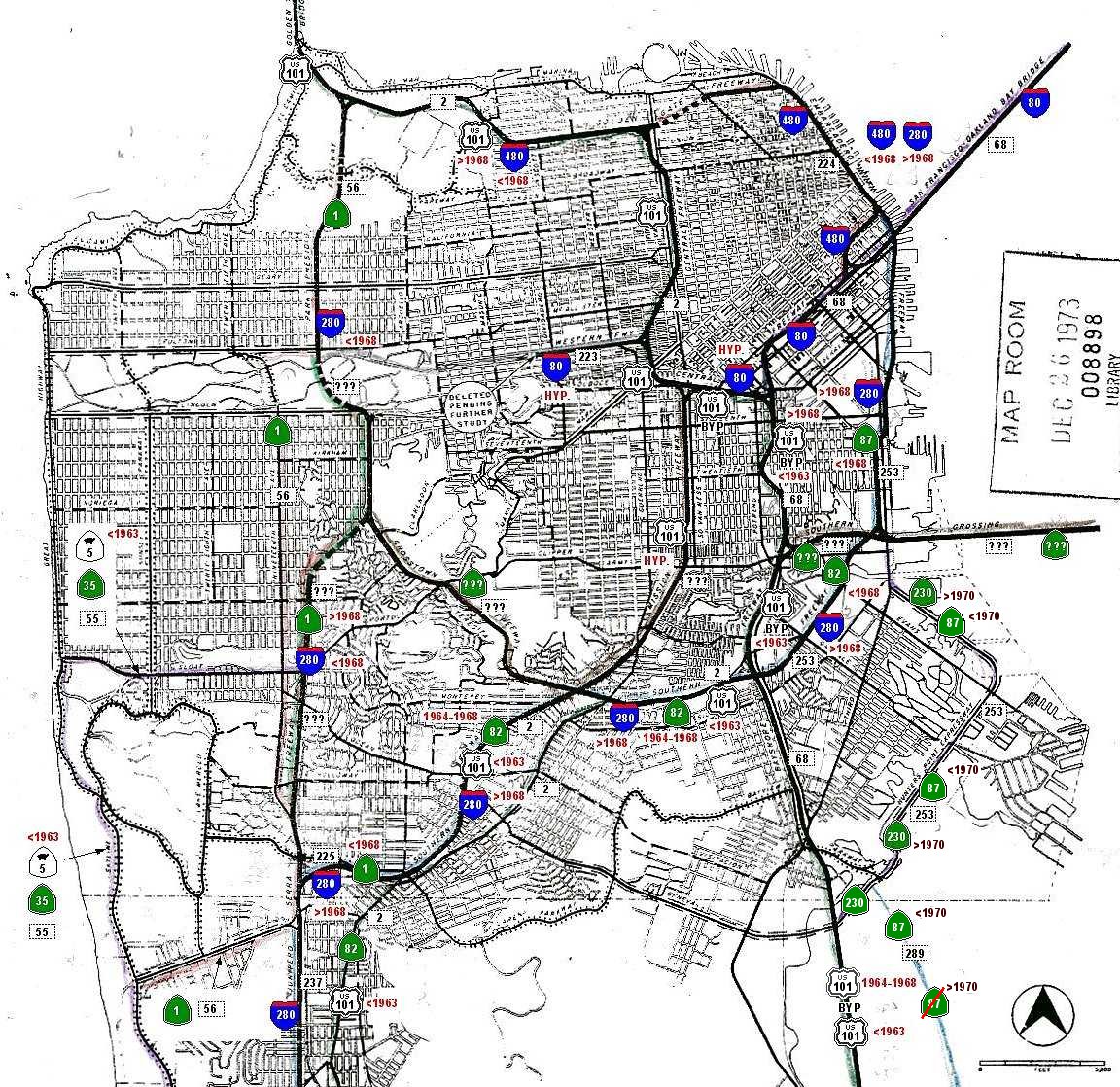