
 California Highways:
Click here for a key to the symbols used. An explanation of acronyms may be found at the bottom of the page.
 Routing
 Post 1964 Signage History
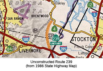
This route remains as defined in 1963. The traversable route is Mountain House Road and Byron Highway. Caltrans has no plans to adopt this route.
 Pre 1964 Signage History
This route was part of proposed LRN 110, defined in 1959. It was unsigned and unconstructed, although it appears to follow the route of Contra Costa/Alameda/San Joaquin County Sign Route J4.
 Status
This routing is unconstructed. The traversable local routing is along Mountain House Road, and Byron Highway, as well as Vasco Road and Walnut Blvd. These existing roads are substandard for incorporation into the state system.
The 2013 Traversable Highways report notes that the closest traversable routings are Moutain House Road and Byron Highway, Vasco Rd, and Walnut Blvd. Existing routes may not meet current highway standards. Route 239 was a portion of the previous proposed mid-state tollway from Sunol to Vacaville. As part of a federal earmark to develop Route 239, Contra Costa Transportation Authority has initiated a Feasibility Study using federal earmark funds to potentially develop a privately owned and operated route or add Route 239 into the State Highway System (see below). This segment is Category 3 — The traversable highway is inadequate or nonexistent, but project studies are scheduled within five years so State assumption of maintenance is a possibility within the next ten years: From Route 580 West of Tracy to Route 4 (17 mi); From Route 4 to Route 205 (Mountain House Road, Byron Highway) (17 mi). IRRS 2003, 2005 SAFETEA-LU allocated $4M to conduct study and construct Route 239 from Route 4 in Brentwood area to I-205 in Tracy area. Received 2 earmarks totaling $14M. In 2005,Contra Costa County was granted $14 million in federal earmarks for planning and construction of Route 239. Contra Costa County is coordinating with SJCOG and San Joaquin County.
This route was originally planned to be a portion of the Mid-State Tollway between Sunol and Vacaville. The tollway was a proposal that would start off of I-680 near Sunol, cross I-580 west of Livermore (roughly along the alignment of the Livermore Bypass), and then will extend north to Route 4 near Antioch. A spur will come off the tollway near Brentwood and run SE to the junction of I-580 and I-205. The tollway could be designated Route 84, since it roughly follows the built and unbuilt portions of the route and the spur could be designated Route 239, since it follows the general routing for that unbuilt highway. The tollway was originally supposed to extend to I-80 between Vacaville and Dixon with a spur connecting with I-505 at the 80/505 junction, but that portion was killed due to the need for high-level crossings (150') of the San Joaquin and Sacramento Rivers plus environmental issues.
Note: For additional information on the Mid-State Tollway, see Route 84.
Scott Parker noted on AAroads that the tollway would have utilized the
path of the oft-considered Route 239, Route 4 between Byron and Antioch,
the Antioch (Route 160) bridge, and diverged from Route 160 north of there
to cross the Sacramento River. It would have had terminating "splits" at
both ends; a Route 84-based branch along Vasco Road, passing between
Livermore and Pleasanton, and terminating at the Route 84 interchange with
I-680 was to be a SW branch, while the main trunk, after crossing the
Sacramento River, would have headed toward Elmira, where it would split
into two branches, one intersecting I-505 about a mile or two north of
I-80 (after crossing the latter freeway) and the other heading toward
Dixon and the I-80/Route 113 freeway interchange between Dixon and Davis
-- the Route 113 freeway would have been its functional extension. The
toll road idea, formulated in the late '80's and early '90's, would have
required a doubling of the Antioch Bridge as well as a 4-lane high-level
bridge (likely cable-stayed) across the Sacramento River north of there.
Even in 1992, the cost for doing the full project was projected at well
over $2 billion; with the center section along Route 4 remaining a free
facility (the present Antioch Bridge toll facility would have marked the
southern end of the northern toll section). The Route 84 branch was itself
mired in controversy; in the '90's the development of the Brentwood area
as an "overflow" housing region for Silicon Valley employment was in its
initial stages; deploying a toll road to serve that commute traffic was
seen as gratuitous money-grubbing and that a conventional freeway would be
more appropriate. But by 1998 the entire project was functionally scrapped
because of the enormous cost; projected toll revenue was far too meager to
even cover the initial construction -- likely due to the myriad
opportunities for shunpiking as well as the perception that the northern
section had limited commuter value and what revenue would accrue would
come from commercial usage -- the most likely candidates to avoid the
tolled facility!
(Source: AARoads "Re: I-5 West Side Freeway", 12/29/2019)
Contra Costa County State Route 239 Project
In 1996, this project was dubbed the Brentwood-Tracy Expressway and
identified in a Metropolitan Transportation Commission (MTC) study as a
long-range project that could benefit the corridor.
(Source: The Press, 7/21/2006)
 By 2000, plans and projects were already in progress to better connect East Contra Costa County with
points west. These include the Route 4 Freeway Widening Project, the Route 4 Bypass, and the eBART system that was then in the planning and
environmental review stages. Given the success in moving these westward
connections along, there was increasing discussion on the need for better
connections in the other direction as well -- from East County to points
east. East County roadways were experiencing a significant increase in
truck traffic to and from the Central Valley, and this, combined with the
rapid growth of East County and limited roadway capacity to the east, led
to the desire to seek funding for a major planning effort to improve these
connections. As such, the County requested an earmark for Route 239
because of growing interest in better highway links to the Central Valley.
In the early 2000s, the only connections between East County and the
Central Valley were undivided two-lane roads (the Byron Highway and Route 4 east of Discovery Bay). The concept of an improved highway link known as
the Brentwood-Tracy Expressway had been included for years in the
Metropolitan Transportation Commission’s Regional Transportation
Plan, but no progress has been made on planning the route. MTC considered
it a long-term, unfunded concept and therefore did not place any priority
on it. The County and the Contra Costa Transportation Authority asked
Caltrans several times to begin the planning and technical studies for the
new route, without success. The County therefore requested a federal
appropriation (earmark) through the office of Representative Pombo to
start planning this long-sought highway. The request was successful and
the County was awarded $14 million for the project in 2005.
By 2000, plans and projects were already in progress to better connect East Contra Costa County with
points west. These include the Route 4 Freeway Widening Project, the Route 4 Bypass, and the eBART system that was then in the planning and
environmental review stages. Given the success in moving these westward
connections along, there was increasing discussion on the need for better
connections in the other direction as well -- from East County to points
east. East County roadways were experiencing a significant increase in
truck traffic to and from the Central Valley, and this, combined with the
rapid growth of East County and limited roadway capacity to the east, led
to the desire to seek funding for a major planning effort to improve these
connections. As such, the County requested an earmark for Route 239
because of growing interest in better highway links to the Central Valley.
In the early 2000s, the only connections between East County and the
Central Valley were undivided two-lane roads (the Byron Highway and Route 4 east of Discovery Bay). The concept of an improved highway link known as
the Brentwood-Tracy Expressway had been included for years in the
Metropolitan Transportation Commission’s Regional Transportation
Plan, but no progress has been made on planning the route. MTC considered
it a long-term, unfunded concept and therefore did not place any priority
on it. The County and the Contra Costa Transportation Authority asked
Caltrans several times to begin the planning and technical studies for the
new route, without success. The County therefore requested a federal
appropriation (earmark) through the office of Representative Pombo to
start planning this long-sought highway. The request was successful and
the County was awarded $14 million for the project in 2005.
(Source: Contra Costa County Status Report, 12/10/2008)
The SAFETEA-LU act, enacted in August 2005 as the reauthorization of TEA-21, provided the following expenditures on or near this route:
In 2005, Contra Costa County secured federal funds to initiate a
feasibility study and a project initiation document (PID). During the
study phase of this project between the spring of 2012 and the winter of
2013, a variety of stakeholder meetings were held and several important
themes emerged, including consideration of how a new route in eastern
Contra Costa might affect conservation areas, agricultural lands, bird
flight paths, and growth in the area. These considerations set the stage
for continued outreach during future project development phases. The PID
was completed in 2015 and the environmental study phase has been
initiated.
(Source: Contra Costa County State Route 239 Page, November 2021)
In July 2006, it was reported that more than $15 million of federal funds
has been earmarked for planning work for the proposed Route 239. However
drivers will wait an estimated five years (until 2011) to see any real
construction begin, according to planners. Planners consider rural Byron
Highway (officially County Sign Route J4) that follows the Union Pacific railroad tracks
from Byron to Tracy woefully inadequate for the volume of traffic that
rolls along it every day. Byron residents have long complained about heavy
trucks creating noise, safety hazards and congestion during peak commute
hours. Route 239 has been a gleam in the eye of transportation planners
for some time now as part of the California Inter-Regional Improvement
program. Route 239 is currently a legislatively approved but as yet
unconstructed route in the state highway system. The project got a big
boost thanks to Congressman Richard Pombo securing the federal funding for
preliminary scoping and planning work. The project needs to jump through
various hoops to secure the funding to reach the construction phase, which
will probably take several years to complete. Those hoops include a
reconnaissance phase currently under way, followed by a feasibility study,
environmental review, route adoption proposal, and right-of-way
preservation. The initial $15 million in funds will pay only for
preliminary planning, environmental review and public outreach over the
next couple of years.
(Source: The Press, 7/21/2006)
There is also an effort by Rep. Pombo to build a freeway along the Route 239 corridor. This freeway would would run along the path of the two-lane
Byron Highway from the western end of Tracy northwest to Brentwood. There,
it would connect with the Route 4 bypass currently scheduled for
construction. Brentwood political leaders have been pushing for the new
freeway to provide the city with a thruway to I-5, I-580, and I-205. The
plan is to attract white-collar and industrial businesses and transform
the city from a bedroom community to a job center. The new freeway
proposal also will give Tracy commuters a connection to the north, and an
alternative commute route to the East Bay. An article in the East Bay
Express notes that the arrival of the federal funds for the Route 239
project also happens to coincide with a multimillion-dollar land deal
currently underway with members of Pombo's family.
(Source: Michael Patrick's Blog, 8/28/2005)
Although the funds were awarded in 2005, the county did not begin the
formal process of accessing the funds until 2008 due to issues with the
way the earmark was written and questions about eligible uses of the
funds. These issues were primarily that the earmarks granted to the County
were for a different purpose than the County had requested. CC County
requested funds for planning, consensus-building and environmental review
to determine the preferred alignment for the new highway. However, the
appropriations we received were for study and “construction”
of the highway. The County did not envision any construction being
performed with the requested funds. This led to unexpectedly lengthy
discussions and correspondence with Caltrans on how to resolve the
situation. The feedback from Caltrans, as recently as April 2008, was that
the county had to construct the new highway or else we would have to give
back the $14 million. However, at a meeting with Caltrans staff on
September 9, 2008, all parties seemed to understand that a new
highway from Brentwood to Tracy cannot be built with $14 million.
The county discussed their intent to use the funds for planning, technical
alignment studies and outreach to the affected communities, hopefully
resulting in
consensus on the preferred alignment for the new highway, and for
pre-construction activities such as environmental review, preliminary
engineering and design, and right-of-way acquisition. After those steps
are all complete, it is possible a small amount of funds may be left
available for a small amount of construction. County staff explored
resolving the “construction” problem through federal
legislation that would remove the word “construction” from the
earmark language. However, that possibility was complicated by the fact
that the earmark sponsor (former Rep. Pombo) was no longer in office.
Congressional custom apparently dictates that earmark language is not
changed unless the sponsoring member approves of the change, even if he or
she is no longer in office. Therefore a legislative solution would have
been difficult, and the current congressional representatives did
not seem eager to attempt it.
(Source: Contra Costa County Status Report, 12/10/2008)
In 2008, the County received a status report on this project. The report
noted that County staff is completing the required paperwork to submit to
Caltrans in order to access the funds. This process is known as a Request
for Authorization, and is required any time the County seeks access to
federal grants. Caltrans administers the federal funds, so the county
request goes to them. The Request for Authorization includes standard
forms that must be filled out, and a work plan that outlines how the
County will carry out the project. Staff intends to submit the request by
the end of 2008. Caltrans must review and approve the submittal before
they grant access to the funds. The submittal is being developed jointly
by the Public Works Department and the Department of Conservation and
Development.
(Source: Contra Costa County Status Report, 12/10/2008)
The Goals of the project are as follows:
(Source: Contra Costa County State Route 239 Page, November 2021)
The schedule for the project is roughly:
(Source: Contra Costa County State Route 239 Page, November 2021)
At the end of December 2021, it was noted that the Route 239 Project
scoping comment period had opened and was running from December 17, 2021,
through February 4, 2022. Per the notice of preparation, Caltrans, in
partnership with the Contra Costa Transportation Authority (CCTA) as the
project sponsor, proposes to provide a new, 4-lane highway from Route 4
near Marsh Creek Road in Contra Costa County to I-205 and/or I-580 in
Alameda County and/or San Joaquin County. This new route would improve the
transportation network for an area that has few north-south roadway
connections between eastern Contra Costa County and the western San
Joaquin Valley. The Route 239 Project would provide relief from commute
traffic through the town of Byron, enhance mobility in eastern Contra
Costa County, and improve access to the Byron Airport. Caltrans and CCTA
are also considering multimodal alternatives for the Route 239 Project.
The overall Route 239 corridor is being evaluated at both a Tier I
(program) level and a Tier II (project) level. Two alternatives for Tier I
are being considered. Alternative A would be a 4-lane highway with an
alignment east of the Byron Airport that would turn southward and connect
to the I-580/I-205 interchange. Alternative B would be a 4-lane highway
with an alignment east of the Byron Airport that would run parallel to and
west of Byron Highway before joining Byron Road and connecting to I-205
west of Tracy. The Tier II, or initial phase, is proposed to be a 2-lane
highway between Route 4 near Marsh Creek Road and the Byron Airport.
(Source: Caltrans District 4 on Twitter, 12/28/2021)
None
 Interregional Route
[SHC 164.19] Entire route. It is believed this designation will provide increased funding. Designated by SB 802, Chapter 598, 9/2003.
 Other WWW Links
 Statistics
Overall statistics for Route 239:
 Freeway
[SHC 253.1] Entire route.
 Scenic Route
[SHC 263.1] Entire route.
 Pre-1964 Legislative Route
In 1957, Chapter 23 defined LRN 239 as “a point on [LRN 56] near Daly City to a point on [LRN 2] near San Jose on a route to be selected by the California Highway Commission, which route may include all or portions of any existing state highway route or routes”. The urgency clause noted this was related to a circumferential freeway around San Francisco Bay.
In 1961, Chapter 1146 rewrote the routing as “the junction of [LRN 68] and [LRN 69] in San Jose to [LRN 56] near Daly City”.
This route is part of I-880 between the US 101/I-880 junction to the I-880/I-280 junction, and is I-280 between from I-880/I-280 N to LRN 56 (Route 1) near Daly City. Between San Bruno and Daly City, the route appears to duplicate LRN 237 (which may be the old surface street routing). Note that the I-280 route includes a portion of LRN 2 between old surface US 101 in Daly City and freeway US 101.
© 1996-2020 Daniel P. Faigin.
Maintained by: Daniel P. Faigin
<webmaster@cahighways.org>.
 FromRoute
  Route 238
 Route 240