
 California Highways:
Click here for a key to the symbols used. An explanation of acronyms may be found at the bottom of the page.
 Routing
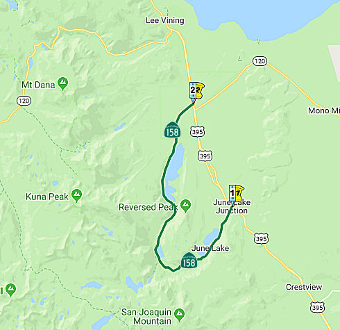 From Route 395 near June Lake to Route 395 near Rush Creek, via the vicinity of June
Lake, Silver Lake and Grant Lake.
From Route 395 near June Lake to Route 395 near Rush Creek, via the vicinity of June
Lake, Silver Lake and Grant Lake.
 Post 1964 Signage History
In 1963, this was defined as the route from "Route 395 near Rush Creek to Route 395 via June Lake."
In 1965, Chapter 1371 clarified the routing: "Route 395 near Rush
Creek June Lake to Route 395 near Rush Creek,
via the vicinity of June Lake, Silver Lake and Grant Lake".
 Pre 1964 Signage History
This was LRN 111, defined in 1933. It appears not to have been signed before 1963, although the route itself dates back to 1933.
The section of roadway south from the north terminus of Route 158 was
constructed during 1915 to Silver Lake for a hydroelectric project on Rush
Creek. The roadway from the southern terminus was built from June Lake
Junction, past June Lake, to Silver Lake by 1924. Apparently there was
enough people in 1927 at June Lake to warrant postal service.
(Source: Tom Fearer (Max Rockatansky) on AARoads, "CA 158 June Lake Loop", 7/9/2017)
Signed Route 158 was not defined as part of the initial state signage of routes in 1934. It is unclear what (if any) route was signed as Route 158 between 1934 and 1964.
 Scenic Route
[SHC 263.1] Entire route.
 Other WWW Links
 Statistics
Overall statistics for Route 158:
 Pre-1964 Legislative Route
In 1933, Chapter 767 defined the route from "[LRN 4] near San Fernando to [LRN 60] near Mines Field" as part of the highway system. In 1935, this was added to the highway code as LRN 158 with that routing.
In the 1947 1st ex. sess., Chapter 11 rewrote the route to be:
This showed the growing planning for the San Diego Freeway, which now ran as far as the Long Beach Freeway.
In 1951, Chapter 1562 combined the segments and extended the route from the Long Beach Freeway to the El Toro Y: "[LRN 4] near San Fernando to [LRN 2] in the vicinity of El Toro; provided, however, that Section 600 of this code shall be applicable to that portion of said route southerly of [LRN 167] near Signal Hill the same as if said portion had been added by the Collier-Burns Act of 1947, and the Department of Public Works shall not be required to maintain any portion of said route until the same has been laid out and constructed as a state highway"
In 1955, Chapter 1488 removed the language relating to section 600 (actually, it just made that language a general condition as Section 2109 of the code).
LRN 158 is present-day I-405; before the freeway was constructed, this LRN also applied to pre-1963 Route 7 between the US 99/US 6 junction and Route 107. The original route was along Sepulveda to the intersection with LRN 60 (Lincoln Blvd).
© 1996-2020 Daniel P. Faigin.
Maintained by: Daniel P. Faigin
<webmaster@cahighways.org>.
 Route 157
 Route 159