
 California Highways:
Click here for a key to the symbols used. An explanation of acronyms may be found at the bottom of the page.
 Routing
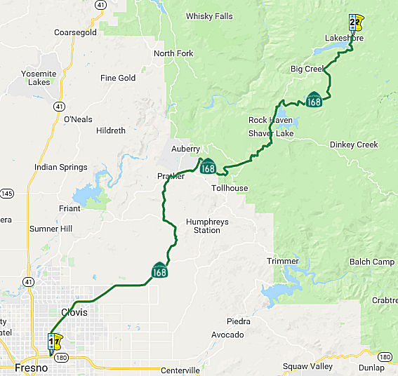 From Fresno to Huntington Lake.
 Post 1964 Signage History
In 1963, this segment was defined as "(a) Route 41 near Fresno to Huntington Lake.
In 1965, Chapter 1371 changed the origin of this segment to simply "Fresno"
It appears that, before the freeway version, this route started at Route 41 and ran along Shaw Ave to Clovis Road, as Clovis Road to Toll House Road, and as Toll House Road to Huntington Lake.
It looks like the highway went from Shaver Lake to Big Creek and Huntington Lake, and not around the south side of the lake, which is the current alignment of the highway. This is supported by the September/October 1956 issue of California Highways, which notes an improvement on this route near Shaver Lake and Huntington Lake. Thus, it is likely that movement to the S side of the lake occured around then.
Route 168 originally was aligned on Tollhouse Road and bypassed Prather.
Route 168 was realigned off Tollhouse Road into Prather and by proxy
partially Auburry Road at some point between 1970 and 1975. The alignment
of Route 168 through Prather was meant to be an interim routing to the
recently completed expressway segment. The expressway was planned to
continue all the way westward towards Clovis. The planned rerouting of CA 168 along with the realignment into Prather can seen on the 1975 Caltrans
State Highway Map. Auberry Road splits away from Route 168 at a recently
constructed roundabout in Prather. Auberry Road continues another
approximately 19 miles to Copper Avenue on the outskirts of Fresno.
Auberry Road west of Prather continues to carry the Wildflower Trail
designation all the way to Copper Avenue.
(Source: Gribblenation Blog "Auberry Road and the Wildflower Trail")
The road into and out of Big Creek is especially mountainous and narrow, with grades nearing 20% and many one-lane sections clinging precipitously to mountainsides. Route 168 also had some major alignment changes between Clovis and Pine Ridge between 1955 and 1974. A four-lane segment of about 9 miles was built to gain the approximately 2700 feet around Tollhouse, and the old routing through Humphreys and Tollhouse was replaced with existing Morgan Canyon (to Prather) and Auberry roads up to the beginning of what's locally called just "the four-lane." The old climb still exists as Tollhouse road and is a favorite of local bicyclists, a key part of the annual Climb to Kaiser ride.
 Pre 1964 Signage History
In 1934, Route 168 was signed along the route from Jct. Route 41 near Fresno to the California-Nevada State Line, via Huntington Lake and Bishop. This segment was originally LRN 76 for its entire route. LRN 76 was defined in 1931.
 Status
As part of this routing, some of the original routing has been relinquished. In particular, the original routings from PM R0.0 to R.08, from 0.4 to 2.0, and from R58.4 to R61.0 in Fresno County were under consideration for relinquishment in December 2000 by the CTC. The original routing from KP R14.8 to KP R19.6 in Fresno County was up for relinquishment in April 2002. The old segment from KP R6.4 to R14.8 was up for relinquishment in August 2002.
Route 168 Freeway - Route 180 to Shepard Road (~ FRE R0.435 to FRE R11.856)
A freeway version of this route is planned/under construction. It will be parallel to and east of Route 41, and will have its southern terminus at a point perpendicular to Route 180. The freeway is now open from the junction with the freeway version of Route 180 to Shepard Ave (~ FRE R0.435R to FRE R11.85). The expressway will end in a remote and unurbanized portion NE of Clovis and will greatly save time for those headed into the Sierra Natl Forest.
According to Joe Rouse in May 2001:
The Route 168 freeway is open between Route 180 and Herndon Ave (~ FRE R6.845). Between Route 180 and Shaw the signs are button copy, nonreflective. North of Shaw they are reflective. The portion from Herndon to where it will meet Shepard Ave/Toll House Rd. (~ FRE R11.856) is nearing completion (I saw signs and lighting were up) and I saw something later that says it will open in August. Because the freeway is incomplete, there is a small sign at Shaw Ave. directing motorists who want to stay on Route 168 to exit there. The controls for Route 168 on the Route 180 freeway are Clovis and Huntington Lake. On surface street approaches to the Route 41, Route 180, and Route 168 freeways, there are no controls, only cardinal directions.
Much to my surprise, there are no signs on Route 41 that direct motorists to use Route 180 to get to Route 168. Route 168 shields have been removed from the signs on Route 41 at Shaw. SB on Route 168 there are no signs indicating a junction with Route 180; the advanced exit signage just lists Route 41 north and south. This makes sense since SB traffic joins WB Route 180. The connectors to EB Route 180 and from WB Route 180 are not in yet, although there are large fill sections in place for the future connectors.
According to Gary Araki in January 2002, Route 168 is now completed from the intersection of Route 180 to the confluence of Toll House Road above Clovis.
In November 2010, the CTC approved for future consideration of funding a project in Fresno County that will construct new braided ramps between Route 41 and Route 168 in the city of Fresno. The project is programmed in the 2010 State Highway Operation and Protection Program. Construction is estimated to begin in Fiscal Year 2010-11. Total estimated project cost is $55,000,000 for capital and support. The project will mitigate potential impacts to noise to a less than significant level by building soundwalls at four locations.
The SAFETEA-LU act, enacted in August 2005 as the reauthorization of TEA-21, provided the following expenditures for or near this route:
In March 2021, the CTC authorized relinquishment of right of way,
consisting of collateral facilities, in the city of Clovis along Route 168
on Temperance Avenue (06-Fre-168-PM R8.9) under the terms and conditions
as stated in City Resolution 18-39 dated February 20, 2018. Per the
relinquishment map, it looks like a small parcel near the southern
entrance of Temperance to the Temperance and Alluvial roundabout. The City
agreed to waive the 90-day notice requirement and accept title upon
relinquishment by the State by letter dated June 3, 2020.
(Source: March 2021 CTC Agenda, Agenda Item 2.3c)
![[Public Road Connection - Clovis]](maps/168-clovis.jpg) In May 2008, the CTC considered a public road connection
at Nees Ave. near Clovis (~ FRE R10.335). The City of Clovis (City)
prepared a FEIR for the approval and construction of a 410 acre mixed use
development and the eventual annexation of all of the unincorporated lands
within the City’s sphere of influence situated northwest of Route 168, south of Shepherd Avenue and east of Temperance Avenue within the
unincorporated area of Fresno County, adjacent to the northeast city
limits of Clovis. As part of the Harlan Ranch Project, the City of Clovis
is constructing an extension of DeWolf Avenue to Route 168. The extension
will provide access from Harlan Ranch to Route 168 at an at-grade
intersection. The existing intersection is fully developed with traffic
signals, and striping for through and turn lanes in all four directions,
and is ultimately planned for a future interchange. The project is fully
funded by the City of Clovis and no state or federal funds will be used.
Construction is estimated to begin within 2 years of authorization of the
public road connection at an estimated cost of $731,000. This section of
Route 168 is a four-lane expressway with 10-foot outside and 5-foot inside
shoulders and an unpaved 85-foot median. Currently, Nees Avenue connects
to Route168 from the south only, via Tollhouse Frontage Road. The proposed
project includes an extension of Nees Avenue from its intersection with
Route 168 northward until it intersects with a small southward extension
of DeWolf Avenue. The new connection to Route 168 will convert this
intersection to a full four-way intersection. A triangular area of
approximately 350 acres, bounded by Shepherd Avenue on the north, Route 168 on the southeast, and DeWolf Avenue on the west is being developed for
residential and commercial mixed uses. Most employment centers and
shopping centers for this region are located south and west of this new
area of development. Use of Route 168 to access these centers is limited
to the Temperance Avenue interchange and the Shepherd Avenue intersection.
These two access points are separated by over two and a half miles.
Circuitous and lengthy routes must be used for those destinations which
are not located in close proximity to these connections. This new
connection will relieve local traffic congestion and provide an important
transportation link between the expressway and the local road system, thus
providing improved emergency and service vehicle access to surrounding
residential and commercial areas north of Route 168.
In May 2008, the CTC considered a public road connection
at Nees Ave. near Clovis (~ FRE R10.335). The City of Clovis (City)
prepared a FEIR for the approval and construction of a 410 acre mixed use
development and the eventual annexation of all of the unincorporated lands
within the City’s sphere of influence situated northwest of Route 168, south of Shepherd Avenue and east of Temperance Avenue within the
unincorporated area of Fresno County, adjacent to the northeast city
limits of Clovis. As part of the Harlan Ranch Project, the City of Clovis
is constructing an extension of DeWolf Avenue to Route 168. The extension
will provide access from Harlan Ranch to Route 168 at an at-grade
intersection. The existing intersection is fully developed with traffic
signals, and striping for through and turn lanes in all four directions,
and is ultimately planned for a future interchange. The project is fully
funded by the City of Clovis and no state or federal funds will be used.
Construction is estimated to begin within 2 years of authorization of the
public road connection at an estimated cost of $731,000. This section of
Route 168 is a four-lane expressway with 10-foot outside and 5-foot inside
shoulders and an unpaved 85-foot median. Currently, Nees Avenue connects
to Route168 from the south only, via Tollhouse Frontage Road. The proposed
project includes an extension of Nees Avenue from its intersection with
Route 168 northward until it intersects with a small southward extension
of DeWolf Avenue. The new connection to Route 168 will convert this
intersection to a full four-way intersection. A triangular area of
approximately 350 acres, bounded by Shepherd Avenue on the north, Route 168 on the southeast, and DeWolf Avenue on the west is being developed for
residential and commercial mixed uses. Most employment centers and
shopping centers for this region are located south and west of this new
area of development. Use of Route 168 to access these centers is limited
to the Temperance Avenue interchange and the Shepherd Avenue intersection.
These two access points are separated by over two and a half miles.
Circuitous and lengthy routes must be used for those destinations which
are not located in close proximity to these connections. This new
connection will relieve local traffic congestion and provide an important
transportation link between the expressway and the local road system, thus
providing improved emergency and service vehicle access to surrounding
residential and commercial areas north of Route 168.
In December 2018, the CTC received an information report about $1,287,000
in funding for: Fresno 06-Fre-168 11.7/R30.0. PPNO 06-6866. Route 168 Near
Prather, from 0.2 mile east of Shepherd Avenue to Lookwood Lane; also from
1.6 miles east of Aubrrey Road to Tollhouse Road (L27.4/36.2). Outcome/Output:
Improve safety by constructing centerline rumble strip. This project will
reduce the number and severity of collisions.
(Source: December 2018 CTC Minutes, Agenda Item 2.5f(3) Item 1)
In September 2010, the CTC approved for future consideration of funding a project in Fresno County that will realign the Shepherd Curve (~ FRE R11.856) along Route 168 near the city of Fresno. The project is programmed in the 2010 State Highway Operation and Protection Program. Construction is estimated to begin in Fiscal Year 2011-12. Total estimated project cost is $5,108,000 for capital and support. The scope as described for the preferred alternative is consistent with the project scope programmed by the Commission in the 2010 State Highway Operation and Protection Program. The project will require construction activities in the habitat of the California tiger salamander and the San Joaquin kit fox, both of which are federally listed endangered and state listed threatened species.
Tollhouse Road to near Alder Springs
Prather Roundabout (~ FRE T30.215)
Caltrans is exploring creating a roundabout on this route at the intersection of Route 168/Auberry Road in Prather. Other potential/planned roundabout locations in the San Joaquin Valley include Route 145/Jensen near Kerman, Route 216/Route 245 in Woodlake, Route 43/Route 137 in Corcoran, Route 190/Road 152 east of Tipton, Route 190/Road 284 east of Porterville, and Route 155/Browning Road in Delano. A 2007 study of 55 roundabouts in the U.S. found a 35% reduction in accidents and a 90% reduction in fatal accidents when intersections with stop signs or signals were converted to roundabouts. It costs about the same to build a roundabout as to put up traffic signals, and they need significantly less maintenance than traffic signal intersections -- about 60% to 90% less, depending on how much landscaping work is required.
In August 2014, the CTC approved for future consideration of funding the project to construct a roundabout at the intersection of Route 168 and Auberry Road near Prather. The total estimated cost was $3,899,000 for capital and project support, and construction was expected to commence in FY15-16.
In March 2016, the CTC approved the following SHOPP project: In Prather, on Route 168 at Auberry Road. Outcome/Output: Construct single-lane roundabout to reduce the number and severity of collisions. Future Consideration of Funding approved under Resolution E-14-36; August 2014. $2,928,000
Alder Springs to Huntington Lake
No status to report.
 Naming
 The segment in Fresno County from Route 180 to Armstrong Avenue (~
FRE R0.000 to FRE R8.529) is named the "Sierra Freeway". Named by
Senate Concurrent Resolution 25, Chapter 85, in 1997.
The segment in Fresno County from Route 180 to Armstrong Avenue (~
FRE R0.000 to FRE R8.529) is named the "Sierra Freeway". Named by
Senate Concurrent Resolution 25, Chapter 85, in 1997.
(Image source: AARoads)
 The segment of Route 168 in the City of Fresno beginning at the interchange with Route 180 (FRE
0.000) and ending at East Shields Avenue (FRE R2.026) in the County of
Fresno is named the Esther Padilla Memorial Highway. It was
named in memory of Esther V. Negrete Padilla, who was born in Fowler,
California, in 1944 and was one of 12 children. Esther was a resident of
the County of Fresno for 69 years and attended college at California State
University, Fresno, receiving her bachelor of arts degree in 1966 and a
master’s degree in social work in 1989. Esther Negrete Padilla had
more than 30 years of social work experience with nonprofit organizations,
including working with the Fresno County Department of Social Services,
Fresno County Head Start, and the Sequoia Community Health Foundation.
Esther volunteered at the United Farm Workers Union for 10 years,
negotiating contracts and lobbying in Washington, D.C., where she met her
husband Gilbert, who also worked for the United Farm Workers Union,
American Federation of Labor and Congress of Industrial Organizations
(AFL-CIO). Esther provided invaluable community relations, outreach, and
media services to the Latino community to raise awareness among Latinos to
promote organ and tissue donation. Esther was the first Latina elected to
the Fresno City Council, where she served a four-year term representing
District 5, a predominately Latino area, from 1991 to 1995, inclusive.
Esther also served as the Mayor pro Tempore and on various commissions and
boards, including the Fresno County Council of Governments, Local Agency
Formation Commission, and Airport Land Use Commission. During her time as
a councilmember, Esther played a vital role in the construction of both
Route 180 and Route 168 by providing the swing vote that gave the order to
begin construction. She also voted in favor of constructing the former
Fresno Grizzlies Stadium, now known as Chukchansi Park. Esther
collaborated effectively with school officials and also with local,
national, and international elected officials. Named by Assembly
Concurrent Resolution (ACR) 139, Res. Chapter 43, 09/14/20.
The segment of Route 168 in the City of Fresno beginning at the interchange with Route 180 (FRE
0.000) and ending at East Shields Avenue (FRE R2.026) in the County of
Fresno is named the Esther Padilla Memorial Highway. It was
named in memory of Esther V. Negrete Padilla, who was born in Fowler,
California, in 1944 and was one of 12 children. Esther was a resident of
the County of Fresno for 69 years and attended college at California State
University, Fresno, receiving her bachelor of arts degree in 1966 and a
master’s degree in social work in 1989. Esther Negrete Padilla had
more than 30 years of social work experience with nonprofit organizations,
including working with the Fresno County Department of Social Services,
Fresno County Head Start, and the Sequoia Community Health Foundation.
Esther volunteered at the United Farm Workers Union for 10 years,
negotiating contracts and lobbying in Washington, D.C., where she met her
husband Gilbert, who also worked for the United Farm Workers Union,
American Federation of Labor and Congress of Industrial Organizations
(AFL-CIO). Esther provided invaluable community relations, outreach, and
media services to the Latino community to raise awareness among Latinos to
promote organ and tissue donation. Esther was the first Latina elected to
the Fresno City Council, where she served a four-year term representing
District 5, a predominately Latino area, from 1991 to 1995, inclusive.
Esther also served as the Mayor pro Tempore and on various commissions and
boards, including the Fresno County Council of Governments, Local Agency
Formation Commission, and Airport Land Use Commission. During her time as
a councilmember, Esther played a vital role in the construction of both
Route 180 and Route 168 by providing the swing vote that gave the order to
begin construction. She also voted in favor of constructing the former
Fresno Grizzlies Stadium, now known as Chukchansi Park. Esther
collaborated effectively with school officials and also with local,
national, and international elected officials. Named by Assembly
Concurrent Resolution (ACR) 139, Res. Chapter 43, 09/14/20.
(Image source: Dignity Memorial)
The Rout 168/Shaw Avenue interchange (~ FRE R4.282) is named the "Robert L. Binger Interchange". Robert Binger was a graduate of California State University, Fresno (Fresno State). He began his career with the Department of Transportation as a Junior Civil Engineer in 1953 by 1992, after working his way through the ranks in the department, became the District Director for District 6. He retired from the department in 1997, he left behind a legacy of transportation improvements, including more than $250,000,000 worth of construction projects in the Fresno metropolitan area. Bob Binger's focus on the future of transportation made him a national expert on a variety of transportation issues. Additionally, Bob Binger served his alma mater, Fresno State, by working on the annual fund drive of The Bulldog Foundation, raising funds to allow thousands of young men and women to earn a college education and compete in intercollegiate athletics; he also served as President of The Bulldog Foundation in 1987. It was named by Senate Concurrent Resolution 102, Chapter 170 in 1998.
 The Bullard Avenue Interchange in the City of Clovis (~ FRE R5.595) is named the "Peter Hillman
Memorial Interchange". Peter Hillman was a Deputy United States
Marshal serving in the federal Eastern District of California (Fresno)
when he was killed in the line of duty. He was a 14-year veteran of the
United States Marshal's Service, having entered that service in the
federal Northern District of California in 1986 and serving in the Fresno
office since 1988. He was known as the "Hillmanator" because of his
relentless pursuit of narcotics fugitives throughout Merced and Stanislaus
Counties. A native of Montana, he received a bachelor's degree in criminal
justice and sociology from Fresno State University in 1976, and served
eight years with the United States Forest Service as a firefighter prior
to joining the U.S. Marshal's service. He also took many out-of-district
special assignments, including, but not limited to, Operation Sunrise,
assisting in the Virgin Islands after Hurricane Marilyn, and assisting at
the 1996 Olympic Games in Atlanta, Georgia. Named by Assembly Concurrent
Resolution 28; Resolution Chapter 59; filed on June 4, 2001.
The Bullard Avenue Interchange in the City of Clovis (~ FRE R5.595) is named the "Peter Hillman
Memorial Interchange". Peter Hillman was a Deputy United States
Marshal serving in the federal Eastern District of California (Fresno)
when he was killed in the line of duty. He was a 14-year veteran of the
United States Marshal's Service, having entered that service in the
federal Northern District of California in 1986 and serving in the Fresno
office since 1988. He was known as the "Hillmanator" because of his
relentless pursuit of narcotics fugitives throughout Merced and Stanislaus
Counties. A native of Montana, he received a bachelor's degree in criminal
justice and sociology from Fresno State University in 1976, and served
eight years with the United States Forest Service as a firefighter prior
to joining the U.S. Marshal's service. He also took many out-of-district
special assignments, including, but not limited to, Operation Sunrise,
assisting in the Virgin Islands after Hurricane Marilyn, and assisting at
the 1996 Olympic Games in Atlanta, Georgia. Named by Assembly Concurrent
Resolution 28; Resolution Chapter 59; filed on June 4, 2001.
(Image source: US Marshall's Service; Officer Down Memorial Page)
 Armstrong") The Herndon Avenue Interchange in the City of Clovis(~ FRE R6.868) is named the "William
H. "Harry" Armstrong Interchange". William H. "Harry" Armstrong was
a Council Member of the City of Clovis between 1970 and 2002, and served
as Mayor of Clovis for four terms: 1982-84, 1990-92, 1994-97, and 1999-01.
He was born in Merced, California, and lived in Clovis since 1962. He is a
Korean War Veteran, Member of American Legion Post 147, and Life Member of
VFW Post 3223. He served the League of California Cities as President,
First Vice President, Second Vice President, Board Member, Executive
Committee, Transportation, Communication, and Public Works Policy
Committee, and has served the South San Joaquin Division of the League of
California Cities as President, Environmental Quality Committee, Human
Resources Development Committee, Chairman of the Legislative Committee,
First Vice President, Labor Relations Committee, and Revenue and Taxation
Committee. He is also the Chairman of the Association of Metropolitan
Water Agencies, the Chairman of the Fresno County Democratic Central
Committee. More significantly with respect to Route 168, he was the
Chairman of the Fresno County Transportation Authority, and worked
diligently to bring the Route 168 freeway project to fruition. Named by
Senate Concurrent Resolution 45, Chapter 46, on August 15, 2002.
The Herndon Avenue Interchange in the City of Clovis(~ FRE R6.868) is named the "William
H. "Harry" Armstrong Interchange". William H. "Harry" Armstrong was
a Council Member of the City of Clovis between 1970 and 2002, and served
as Mayor of Clovis for four terms: 1982-84, 1990-92, 1994-97, and 1999-01.
He was born in Merced, California, and lived in Clovis since 1962. He is a
Korean War Veteran, Member of American Legion Post 147, and Life Member of
VFW Post 3223. He served the League of California Cities as President,
First Vice President, Second Vice President, Board Member, Executive
Committee, Transportation, Communication, and Public Works Policy
Committee, and has served the South San Joaquin Division of the League of
California Cities as President, Environmental Quality Committee, Human
Resources Development Committee, Chairman of the Legislative Committee,
First Vice President, Labor Relations Committee, and Revenue and Taxation
Committee. He is also the Chairman of the Association of Metropolitan
Water Agencies, the Chairman of the Fresno County Democratic Central
Committee. More significantly with respect to Route 168, he was the
Chairman of the Fresno County Transportation Authority, and worked
diligently to bring the Route 168 freeway project to fruition. Named by
Senate Concurrent Resolution 45, Chapter 46, on August 15, 2002.
(Image source: Fresno Bee)
 The segment within the City of Clovis, from the Herndon Avenue Interchange to the Temperance Avenue Interchange (~ FRE R6.868 to
FRE R9.175) is officially named the "Deputy Sheriff Erik Jon Telen
Memorial Highway". Deputy Erik Jon Telen was born in Clovis,
California, to Don and Sharon Telen. He attended the Fresno City Police
Academy, where he excelled, receiving top of the class honors in 1997.
Upon graduating from the Fresno City Police Academy, Deputy Telen joined
the Ontario, California, Police Department in August of 1997. In the fall
of 2000, he returned home to his family in the Clovis area, where he
joined the Fresno County Sheriff's Department. Deputy Telen was mortally
wounded when he was gunned down while protecting the public on August 21,
2001. He was survived by his wife, Shelley, his daughters, Bethany and
Brooke, his son, Erik Jon Telen, Jr., his mother, Sharon Telen, and his
brother Danny Telen. Named by Senate Concurrent Resolution 43, Chapter 70,
May 31, 2002.
The segment within the City of Clovis, from the Herndon Avenue Interchange to the Temperance Avenue Interchange (~ FRE R6.868 to
FRE R9.175) is officially named the "Deputy Sheriff Erik Jon Telen
Memorial Highway". Deputy Erik Jon Telen was born in Clovis,
California, to Don and Sharon Telen. He attended the Fresno City Police
Academy, where he excelled, receiving top of the class honors in 1997.
Upon graduating from the Fresno City Police Academy, Deputy Telen joined
the Ontario, California, Police Department in August of 1997. In the fall
of 2000, he returned home to his family in the Clovis area, where he
joined the Fresno County Sheriff's Department. Deputy Telen was mortally
wounded when he was gunned down while protecting the public on August 21,
2001. He was survived by his wife, Shelley, his daughters, Bethany and
Brooke, his son, Erik Jon Telen, Jr., his mother, Sharon Telen, and his
brother Danny Telen. Named by Senate Concurrent Resolution 43, Chapter 70,
May 31, 2002.
(Image source: Fresno Sheriff Wall of Honor)
 The interchange of Route 168
at Fowler Avenue, PM FRE R8.042, in the City of Clovis is named the
“Dr. Fareed Wade Nader Memorial Interchange”. It was
named in memory of Dr. Fareed Wade Nader, who was born in September 1938
in the Miami, Arizona. He was the son of immigrants to the United States
from Lebanon. Dr. Nader became an accomplished scholar, earning a
bachelor’s degree in civil engineering from the University of
Arizona in 1961, a master’s degree from Arizona State University in
1963, and a PhD in Surveying and Mapping from Purdue University in 1973.
Dr. Nader worked for the Federal Aviation Administration before beginning
a 35-year teaching career. Dr. Nader taught surveying and
photogrammetry at the University of Hawaii for 5 years before securing a
position at California State University, Fresno (CSUF), where he taught
geomatics engineering for 30 years. Dr. Nader’s passion for teaching
and geomatics was evidenced by his numerous achievements, including being
the second chairman of the CSUF Department of Geomatics and organizing and
overseeing the 1984 International Surveying Teachers’ Conference
held at CSUF. He was the recipient of numerous teaching awards, including
the Instructor of the Year Award in Surveying in 1991, the Dean’s
Leadership Award for Outstanding Service to the School of Engineering and
Computer Science in 1998, and the California Land Surveyors’
Association Honorary Land Surveyor’s License No. 2, and was voted
Professor Emeritus for Geomatics Engineering in 2008. Dr. Nader was a
member of numerous professional organizations, including the American
Congress on Surveying and Mapping, the American Society for Engineering
Education, the American Society of Civil Engineers, the California Land
Surveyors Association, the Geospatial Information and Technology
Association, and the World Future Society. He was also a member of the
Advisory Council for the School of Engineering and Computer Science at
Purdue University, as well as a member of several honorary engineering
societies, including Tau Beta Pi, Chi Epsilon, and Lambda Sigma. He was
also the designer for the end of Route 168 in the City of Clovis, and his
design will forever be a lasting gift to the northeast Clovis community
because it's simple, efficient, and cost-effective engineering design kept
the community intact by enabling all of its residents to keep their homes
and still gain easy access to Route 168. The Department of Transportation
embraced his design as a welcome modification to one of its existing
30-year plans. Named by Assembly Resolution ACR 142, Res. Chapter 130, 08/19/22.
The interchange of Route 168
at Fowler Avenue, PM FRE R8.042, in the City of Clovis is named the
“Dr. Fareed Wade Nader Memorial Interchange”. It was
named in memory of Dr. Fareed Wade Nader, who was born in September 1938
in the Miami, Arizona. He was the son of immigrants to the United States
from Lebanon. Dr. Nader became an accomplished scholar, earning a
bachelor’s degree in civil engineering from the University of
Arizona in 1961, a master’s degree from Arizona State University in
1963, and a PhD in Surveying and Mapping from Purdue University in 1973.
Dr. Nader worked for the Federal Aviation Administration before beginning
a 35-year teaching career. Dr. Nader taught surveying and
photogrammetry at the University of Hawaii for 5 years before securing a
position at California State University, Fresno (CSUF), where he taught
geomatics engineering for 30 years. Dr. Nader’s passion for teaching
and geomatics was evidenced by his numerous achievements, including being
the second chairman of the CSUF Department of Geomatics and organizing and
overseeing the 1984 International Surveying Teachers’ Conference
held at CSUF. He was the recipient of numerous teaching awards, including
the Instructor of the Year Award in Surveying in 1991, the Dean’s
Leadership Award for Outstanding Service to the School of Engineering and
Computer Science in 1998, and the California Land Surveyors’
Association Honorary Land Surveyor’s License No. 2, and was voted
Professor Emeritus for Geomatics Engineering in 2008. Dr. Nader was a
member of numerous professional organizations, including the American
Congress on Surveying and Mapping, the American Society for Engineering
Education, the American Society of Civil Engineers, the California Land
Surveyors Association, the Geospatial Information and Technology
Association, and the World Future Society. He was also a member of the
Advisory Council for the School of Engineering and Computer Science at
Purdue University, as well as a member of several honorary engineering
societies, including Tau Beta Pi, Chi Epsilon, and Lambda Sigma. He was
also the designer for the end of Route 168 in the City of Clovis, and his
design will forever be a lasting gift to the northeast Clovis community
because it's simple, efficient, and cost-effective engineering design kept
the community intact by enabling all of its residents to keep their homes
and still gain easy access to Route 168. The Department of Transportation
embraced his design as a welcome modification to one of its existing
30-year plans. Named by Assembly Resolution ACR 142, Res. Chapter 130, 08/19/22.
(Image source: Obituary)
 The portion from the Temperance Avenue interchange to Shepherd Avenue (~ FRE R9.175 to
FRE R11.835) in the City of Clovis is officially named the "Deputy
Sheriff Dennis E. Phelps Memorial Highway". It was named in honor of
Deputy Sheriff Dennis E. Phelps of the Fresno County Sheriff's Department,
who was killed on May 19, 2002 while in the performance of his duty to the
citizens he was sworn to protect. Deputy Sheriff Phelps had served with
the Fresno County Sheriff's Department in the early 1980's as a sheriff's
bailiff assigned to the Fresno County Superior Court, and after later
working as a locomotive engineer with the Burlington Northern Santa Fe
Railway, he returned to the Fresno County Sheriff's Department as a Level
I Reserve Deputy Sheriff. In order to spend more time with his family and
to fulfill a lifelong dream, Deputy Phelps was sworn in as a deputy
sheriff on October 30, 2000 and after completing a tour serving in the
courts, Deputy Phelps was assigned to the Field Training Program where he
successfully completed his training. During his second week of patrol,
Deputy Sheriff Phelps stopped a suspicious vehicle and was gunned down by
the driver, a 21 year-old Clovis man who had been involved in a shooting
incident in the City of Clovis a short time before. Deputy Sheriff Phelps
was transported to Clovis District Hospital for treatment but his wounds
proved fatal. The shooter escaped with Deputy Sheriff Phelps' sidearm and
patrol vehicle. After a six day search and pursuit involving hundreds of
officers from numerous agencies, the gunman was shot and killed. Named by
Senate Concurrent Resolution 17, Chapter 106, 7/24/2003.
The portion from the Temperance Avenue interchange to Shepherd Avenue (~ FRE R9.175 to
FRE R11.835) in the City of Clovis is officially named the "Deputy
Sheriff Dennis E. Phelps Memorial Highway". It was named in honor of
Deputy Sheriff Dennis E. Phelps of the Fresno County Sheriff's Department,
who was killed on May 19, 2002 while in the performance of his duty to the
citizens he was sworn to protect. Deputy Sheriff Phelps had served with
the Fresno County Sheriff's Department in the early 1980's as a sheriff's
bailiff assigned to the Fresno County Superior Court, and after later
working as a locomotive engineer with the Burlington Northern Santa Fe
Railway, he returned to the Fresno County Sheriff's Department as a Level
I Reserve Deputy Sheriff. In order to spend more time with his family and
to fulfill a lifelong dream, Deputy Phelps was sworn in as a deputy
sheriff on October 30, 2000 and after completing a tour serving in the
courts, Deputy Phelps was assigned to the Field Training Program where he
successfully completed his training. During his second week of patrol,
Deputy Sheriff Phelps stopped a suspicious vehicle and was gunned down by
the driver, a 21 year-old Clovis man who had been involved in a shooting
incident in the City of Clovis a short time before. Deputy Sheriff Phelps
was transported to Clovis District Hospital for treatment but his wounds
proved fatal. The shooter escaped with Deputy Sheriff Phelps' sidearm and
patrol vehicle. After a six day search and pursuit involving hundreds of
officers from numerous agencies, the gunman was shot and killed. Named by
Senate Concurrent Resolution 17, Chapter 106, 7/24/2003.
(Image source: Officer Down Memorial Page)
 Nehring") The portion of Route 168 between Lodge Road (FRE L27.368)
and Qualls Prather Road (FRE L28.250) in the County of Fresno is named the
“Lieutenant Colonel Seth “Jethro” Nehring Memorial
Highway”. It was named in memory of Lieutenant Colonel Seth
“Jethro” Nehring, who was born in April 1974 in Fresno,
California. Nehring was a graduate of Clovis High School and remained
active in sports, enjoyed swimming and water polo, was a member of the
Clovis Judo Club, and continued with various forms of martial arts
throughout his life. He was also an avid outdoorsman, enjoyed studying
history, and was an instructor with the National Rifle Association. In
1994, Nehring joined the California Air National Guard, serving with
distinction as an enlisted Crew Chief. Through his hard work and
dedication, Nehring was selected for commissioning and went on to complete
Undergraduate Pilot Training. In 1998, Nehring received his Bachelor of
Science Degree in Aeronautics/Aviation Science and Technology from
Embry-Riddle Aeronautical University. With over 20 years as a Fighter
Pilot, Nehring achieved more than 2300 Flight Hours, flying both the F-16
Falcon and most recently the F-15 Eagle. In his civilian capacity, Nehring
was a pilot with Southwest Airlines. Nehring was killed in a training
accident, on October 16, 2018, during Clear Sky 2018, a joint military
exercise between the United States Air Force and the Country of Ukraine,
in the Khmelnytskyi Region of Ukraine. Named by Assembly Resolution ACR 164, Res. Chapter 136, 08/19/22.
The portion of Route 168 between Lodge Road (FRE L27.368)
and Qualls Prather Road (FRE L28.250) in the County of Fresno is named the
“Lieutenant Colonel Seth “Jethro” Nehring Memorial
Highway”. It was named in memory of Lieutenant Colonel Seth
“Jethro” Nehring, who was born in April 1974 in Fresno,
California. Nehring was a graduate of Clovis High School and remained
active in sports, enjoyed swimming and water polo, was a member of the
Clovis Judo Club, and continued with various forms of martial arts
throughout his life. He was also an avid outdoorsman, enjoyed studying
history, and was an instructor with the National Rifle Association. In
1994, Nehring joined the California Air National Guard, serving with
distinction as an enlisted Crew Chief. Through his hard work and
dedication, Nehring was selected for commissioning and went on to complete
Undergraduate Pilot Training. In 1998, Nehring received his Bachelor of
Science Degree in Aeronautics/Aviation Science and Technology from
Embry-Riddle Aeronautical University. With over 20 years as a Fighter
Pilot, Nehring achieved more than 2300 Flight Hours, flying both the F-16
Falcon and most recently the F-15 Eagle. In his civilian capacity, Nehring
was a pilot with Southwest Airlines. Nehring was killed in a training
accident, on October 16, 2018, during Clear Sky 2018, a joint military
exercise between the United States Air Force and the Country of Ukraine,
in the Khmelnytskyi Region of Ukraine. Named by Assembly Resolution ACR 164, Res. Chapter 136, 08/19/22.
(Image source: KOLO ABC 8)
 The portion of Route 168 from the intersection of Dragonfly Lane and Tollhouse Road to
Ockenden Ranch Road in Fresno County (~ FRE R36.178 to FRE 44.099) is
officially named the "Deputy Sheriff Joel B. Wahlenmaier Memorial
Highway" This segment was named in honor of Deputy Sheriff Joel B.
Wahlenmaier of the Fresno County Sheriff's Office, who was killed on
February 25, 2010, while in performance of his duties to the citizens he
was sworn to protect. Wahlenmaier was born in Bakersfield and raised in
Fresno, attending local schools and Reedley College. Upon joining the
Fresno County Sheriff's Office in 1998, Wahlenmaier worked in the Patrol
Division and as a detective assigned to the Robbery/Property Crimes and
Homicide units. He was also a long-time member of the Sheriff's Search
& Rescue Team. Deputy Sheriff Wahlenmaier was a dedicated officer who
served his community and loved his profession. On February 25, 2010,
Deputy Sheriff Wahlenmaier was investigating a felony assault case in the
town of Minkler, California, in eastern Fresno County. While Deputy
Sheriff Wahlenmaier was serving a search warrant, the suspect ambushed the
law enforcement officers with gunfire. Wahlenmaier suffered gunshot wounds
that resulted in his death upon his arrival at Community Regional Medical
Center. The subsequent investigation found that the suspect, a 51-year-old
Minkler man, was angry with other residents of the town and had planned to
ambush law enforcement officers if they attempted to contact him. The
suspect committed suicide during the incident. Reedley Police Officer
Javier Bejar was also killed in the gun battle. Named by Assembly
Concurrant Resolution (ACR) 164, 9/14/2010, Resolution Chapter 152.
The portion of Route 168 from the intersection of Dragonfly Lane and Tollhouse Road to
Ockenden Ranch Road in Fresno County (~ FRE R36.178 to FRE 44.099) is
officially named the "Deputy Sheriff Joel B. Wahlenmaier Memorial
Highway" This segment was named in honor of Deputy Sheriff Joel B.
Wahlenmaier of the Fresno County Sheriff's Office, who was killed on
February 25, 2010, while in performance of his duties to the citizens he
was sworn to protect. Wahlenmaier was born in Bakersfield and raised in
Fresno, attending local schools and Reedley College. Upon joining the
Fresno County Sheriff's Office in 1998, Wahlenmaier worked in the Patrol
Division and as a detective assigned to the Robbery/Property Crimes and
Homicide units. He was also a long-time member of the Sheriff's Search
& Rescue Team. Deputy Sheriff Wahlenmaier was a dedicated officer who
served his community and loved his profession. On February 25, 2010,
Deputy Sheriff Wahlenmaier was investigating a felony assault case in the
town of Minkler, California, in eastern Fresno County. While Deputy
Sheriff Wahlenmaier was serving a search warrant, the suspect ambushed the
law enforcement officers with gunfire. Wahlenmaier suffered gunshot wounds
that resulted in his death upon his arrival at Community Regional Medical
Center. The subsequent investigation found that the suspect, a 51-year-old
Minkler man, was angry with other residents of the town and had planned to
ambush law enforcement officers if they attempted to contact him. The
suspect committed suicide during the incident. Reedley Police Officer
Javier Bejar was also killed in the gun battle. Named by Assembly
Concurrant Resolution (ACR) 164, 9/14/2010, Resolution Chapter 152.
(Image source: KMPH, Find a Grave)
 Freeway
[SHC 253.7] Entire portion.
 Scenic Route
[SHC 263.7] From Route 65 near Clovis to Huntington Lake.
 From Camp Sabrina to Route 395.
Post 1964 Signage HistoryThis segment remains as defined in 1963
"(c) Big Pine to the Nevada state line via Oasis."
Pre 1964 Signage HistoryIn 1934, Route 168 was signed along the route from Jct. Route 41 near Fresno to the California-Nevada State Line, via Huntington Lake and Bishop. This route was originally LRN 76 for its entire route. LRN 76 was defined in 1931.
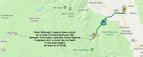
StatusThe state documents state "Note that the traversable road from Huntington Lake to Camp Sabrina is not part of the legislative route." However, there is no traversable road connecting Huntington Lake to Camp Sabrina. Sabrina (and North Lake just north of Sabrina, and South Lake just southeast) is the end of the road on the east side of the Sierra.
 According to the Vermilion Valley Resort, when you drive past Huntington Lake and start up
the road to the resort, there is a Forest Service gate that closes during
the off season. To the left, there is a little stretch of two-lane highway
that dead ends about an 1/8th of a mile up. This is the start of what was
to be Route 168 all the way to the East Side. There is also a stretch of
proposed Route 168 up to Lake Sabrina. When the wilderness was
established, the plans to push the highway were abandoned. This would be
seemingly off Kaiser Pass Road (as the road to the resort is Kaiser Pass
Road to Edison Lake Road). There's a good article on the proposed Piute
Pass Road at the Forest Service website: "The High Sierra Piute Highway" (Steve Marsh, 2015) That article notes:
According to the Vermilion Valley Resort, when you drive past Huntington Lake and start up
the road to the resort, there is a Forest Service gate that closes during
the off season. To the left, there is a little stretch of two-lane highway
that dead ends about an 1/8th of a mile up. This is the start of what was
to be Route 168 all the way to the East Side. There is also a stretch of
proposed Route 168 up to Lake Sabrina. When the wilderness was
established, the plans to push the highway were abandoned. This would be
seemingly off Kaiser Pass Road (as the road to the resort is Kaiser Pass
Road to Edison Lake Road). There's a good article on the proposed Piute
Pass Road at the Forest Service website: "The High Sierra Piute Highway" (Steve Marsh, 2015) That article notes:
(Source: FB post by Vermilion Valley Resort, August 2020)
[Route 168] passes Shaver Lake and ends at Huntington Lake, where an offshoot, Kaiser Pass Road, continues up the mountain. About four miles up, Kaiser Pass Road turns into a rough, potholed, slightly-bigger-than-one-lane mountain road, that the traveler can follow all the way to Florence Lake, at the edge of the John Muir Wilderness. But once upon a time, there were dreams that the road would not end there. Early California motor enthusiasts and business interests had plans to continue the road, up the South Fork of the San Joaquin River, along Piute Creek, and over 11,423’ Piute Pass to the east slope of the Sierras and to the town of Bishop. This would be the High Sierra Piute Highway, a trans-Sierran road that would allow travelers to easily cross the Sierras, experience some country that was compared to the Swiss Alps, and boost the economies of Fresno and Inyo Counties. The highway was an idea that flourished briefly, and then withered, leaving the Sierran wilderness between Yosemite and Sequoia-Kings Canyon National Parks unmarred by concrete, asphalt, and motorized vehicles.
(Source: "The High Sierra Piute Highway" (Steve Marsh, 2015))
Tom Fearer also investigated this routing, noting that it was essentially
an extension of Kaiser Pass Road over the summit (11,423 feet) and down to
Bishop. He also found the 2015 Steve Marsh report (pdf) (cited above) that gives a detailed history of the highway and the various attempts to get it built over the years. In
his discussion on AAroads, he cited the portion of the report where it
noted: "Early California motor enthusiasts and business interests had
plans to continue the road, up the South Fork of the San Joaquin River,
along Piute Creek, and over 11,423’ Piute Pass to the east slope of
the Sierras and to the town of Bishop. This would be the High Sierra Piute
Highway, a trans-Sierran road that would allow travelers to easily cross
the Sierras, experience some country that was compared to the Swiss Alps,
and boost the economies of Fresno and Inyo Counties. The highway was an
idea that flourished briefly, and then withered, leaving the Sierran
wilderness between Yosemite and Sequoia-Kings Canyon National Parks
unmarred by concrete, asphalt, and motorized vehicles." However, a pass at
11,400 ft.+ would be by far the highest-elevation cross-Sierra facility on
the state network, rivaling the many 11K+ passes in Colorado -- and would
probably also have the longest winter closure as well! It is not
surprising it was considered and then discarded; the maintenance costs
would be prohibitive -- particularly for a road likely open barely 5-6
months per year.
(Source: AARoads Discussion, September 2017)
In May 2019, the CTC approved the following SHOPP Support Phase
allocation: 09-Iny-168 16.0/17.7. Route 168 In and near Bishop, from west
of Meadow Lane to east of Pioneer Lane. Construct a two-way left turn
lane. PPNO 2617. ProjID 0914000030. PS&E $545,000. R/W Sup $8,000.
(Source: May 2019 CTC Minutes, Agenda Item
2.5b.(2a) Item 22)
Naming Route 168 from 4090 West Line Street to the junction of US 395 (~
INY 15.084 to INY 18.281), in the County of Inyo, California, is named the
"Richard “Dick” Noles Memorial Highway". It was named
in memory of Richard “Dick” Noles, who was born in Palo Alto,
California, in June 1933, grew up in the Bakersfield area, and graduated
from Bakersfield High School in 1951. Dick went to work for Southern
California Edison in Kernville before transferring to Oxnard, Torrance,
and later to Bishop, where he worked for many years before retiring in
1990. Dick also enjoyed nearly 50 years of volunteer work in the Owens
Valley, an area he dearly loved. Dick made many contributions as an active
volunteer on projects involving the expansion of parks, the improvement of
water quality for wildlife in the local mountains, and the establishment
of the Eastern Sierra All Terrain Vehicle Adventure Trail System in Inyo
County. Dick also helped to establish platforms for handicapped
individuals at local ponds, and gathered volunteers to monitor radio
collars on Buttermilk deer herd winter range areas so that the deer could
be monitored to determine mortality rates and the cause of fatalities in
those deer populations. Named by Assembly Concurrent Resolution (ACR) 115,
Res. Chapter 118, Statutes of 2016, August 16, 2016.
Route 168 from 4090 West Line Street to the junction of US 395 (~
INY 15.084 to INY 18.281), in the County of Inyo, California, is named the
"Richard “Dick” Noles Memorial Highway". It was named
in memory of Richard “Dick” Noles, who was born in Palo Alto,
California, in June 1933, grew up in the Bakersfield area, and graduated
from Bakersfield High School in 1951. Dick went to work for Southern
California Edison in Kernville before transferring to Oxnard, Torrance,
and later to Bishop, where he worked for many years before retiring in
1990. Dick also enjoyed nearly 50 years of volunteer work in the Owens
Valley, an area he dearly loved. Dick made many contributions as an active
volunteer on projects involving the expansion of parks, the improvement of
water quality for wildlife in the local mountains, and the establishment
of the Eastern Sierra All Terrain Vehicle Adventure Trail System in Inyo
County. Dick also helped to establish platforms for handicapped
individuals at local ponds, and gathered volunteers to monitor radio
collars on Buttermilk deer herd winter range areas so that the deer could
be monitored to determine mortality rates and the cause of fatalities in
those deer populations. Named by Assembly Concurrent Resolution (ACR) 115,
Res. Chapter 118, Statutes of 2016, August 16, 2016.
(Image source: Sierra Wave Media)
Scenic Route[SHC 263.7] Entire portion.
 Interregional Route
[SHC 164.18] Between the east urban limits of Fresno and Route 168 at Florence Lake Road, and between Route 168 near Lake Sabrina and Route 395.
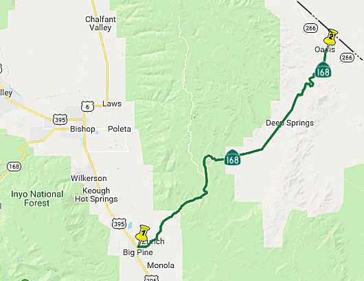 From Route 395 at Big Pine to Route 266 at Oasis.
Post 1964 Signage HistoryIn 1963, this segment was defined as "(c) Big Pine to the Nevada state line via Oasis."
In 1986, Chapter 928 clarified (c): "Route 395 at Big Pine to Nevada
State Line via Route 266 at Oasis." The portion from
Oasis to the Nevada State Line was transferred to Route 266.
Pre 1964 Signage History In 1934, Route 168 was signed along the route from Jct. Route 41
near Fresno to the California-Nevada State Line, via Huntington Lake and
Bishop. This means that originally (i.e., as part of the original signage
of Route 168 in 1934), the portion from US 395 east (this segment) was not
designated as Route 168; instead, the current Route 168 followed what is
now Route 6 (US 6) between Bishop and the Nevada State Line. This route
was originally LRN 76 for its entire route. LRN 76 was defined in 1931.
In 1934, Route 168 was signed along the route from Jct. Route 41
near Fresno to the California-Nevada State Line, via Huntington Lake and
Bishop. This means that originally (i.e., as part of the original signage
of Route 168 in 1934), the portion from US 395 east (this segment) was not
designated as Route 168; instead, the current Route 168 followed what is
now Route 6 (US 6) between Bishop and the Nevada State Line. This route
was originally LRN 76 for its entire route. LRN 76 was defined in 1931.
The new routing between Big Pine and Oasis (originally the Nevada state line) was LRN 63, defined in 1919. It appears to have not been signed before 1964.
Scenic Route National Trails
 The portion of this segment over Westgard pass was part of the "Midland Trail.
 Classified Landcaped Freeway
The following segments are designated as Classified Landscaped Freeway:
| County | Route | Starting PM | Ending PM |
| Fresno | 168 | 0.00 | 9.43 |
 Exit Information
 Other WWW Links
 Statistics
Overall statistics for Route 168:
 Pre-1964 Legislative Route
This route was defined in 1933 as part of a route running from
“[LRN 60] near Long Beach to [LRN 9] near Lamanda Park”. In
1935, it was assigned the number LRN 168, with those same words. In 1961,
Chapter 1146 clarified the terminus of the route to “[LRN 9] near Lamanda
Park Pasadena”, and by 1963 and the "great
renumbering", the definition was “[LRN 60] near Long Beach to [LRN 9] near Pasadena”.
This was Route 19 between Long Beach and Route 164 in Pico Rivera, and then Route 164 into Pasadena. The Route 164 portion, however, has always been signed as Route 19.
© 1996-2020 Daniel P. Faigin.
Maintained by: Daniel P. Faigin
<webmaster@cahighways.org>.
 Route 167
 Route 169