
 California Highways:
Click here for a key to the symbols used. An explanation of acronyms may be found at the bottom of the page.
 Routing
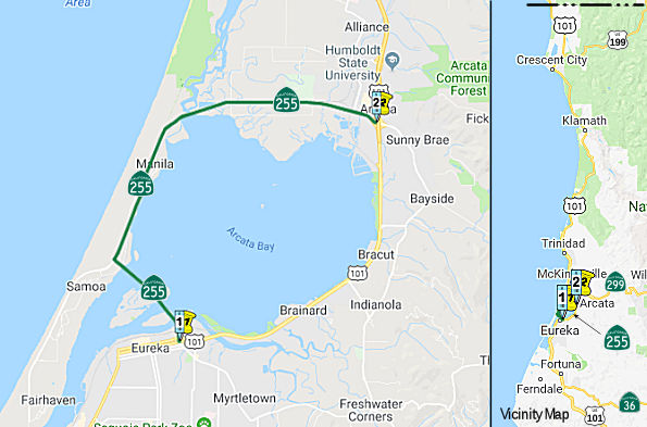 From Route 101 in Eureka to Route 101 in Arcata via the Humboldt Bay Bridge and the
Samoa Peninsula.
From Route 101 in Eureka to Route 101 in Arcata via the Humboldt Bay Bridge and the
Samoa Peninsula.
 Post 1964 Signage History
In 1963, Chapter 1898 defined Route 255 as “Route 101 in Eureka across Humboldt Bay to the Samoa Peninsula” (note: this act added the same route as LRN 294, but that change did not take effect)
In 1970, Chapter 881 extended the route: “Route 101 in Eureka across
Humboldt Bay to the Samoa Peninsula to Route 101 near
Arcata via the Humboldt Bay Bridge and the Samoa Peninsula”
Chapter 1473 that year also redefined the route, but made no changes.
In 1994, Chapter 1220 clarified the routing: “Route 101 in Eureka
to Route 101 in near Arcata via the Humboldt Bay
Bridge and the Samoa Peninsula”
 Pre 1964 Signage History
This route would have been LRN 294, defined in 1963, but that was overtaken by events.
Prior to Route 255 automotive access to the Samoa Peninsula was either
via ferry or taking a long drive around Arcata Bay. The Samoa
Peninsula traditionally has been the head of what was until recent decades
a large lumber industry in Humboldt County.
(Source: Gribblenation Blog "California State Route 255")
 Status
In mid-January 2012, residents of the community of Manila (~ HUM 2.048 to
HUM R5.087) installed signage at both entrances to Manila off Route 255
urging motorists to drive safely. Route 255 divides Manila in half. The
Pacific Ocean, the beach and dunes, community center, Manila Dunes
Recreation Area, the Humboldt Coastal Nature Center and Family Resource
Center lie west of the highway. Half of Manila’s population, two
churches, the Manila Park and access to Humboldt Bay lie to the east. It
is difficult to cross the highway safely because of the high rate of speed
of oncoming vehicles and also because of the curves on Route 255 at the
Dean Avenue/Pacific Boulevard and the Young Lane/north Peninsula Drive
intersections. Manila residents have expressed their safety concerns to
representatives of Caltrans at least since the 1970s.
(Source: Arcata Eye, 1/13/2012)
Eureka/Arcta Restoration Project for Mitigation (HUM 6.0 to 7.6)
The 2018 STIP, approved at the CTC March 2018 meeting, appears to allocate funding for PPNO 2389, 01-HUM-255 6.0/7.6, the Eureka/Arcta Restoration Project for Mitigation - 3 Parcels (an offshoot of PPNO 0072 on US 101). This is in the vicinity of Eureka & Arcata along Route 255. Construct a wetland restoration project including three parcels as off site mitigation for parent project PPNO 0072, including wetland restoration consisting of freshwater wetland expansion, muted tidal restoration of salt marsh habitat, or a full-tidal restoration of salt marsh habitat. This restoration project will serve as mitigation for the parent project, EA 36600, the US 101 Eureka to Arcata Corridor Improvement Project. The parcels are:
The 2018 increases the funding from $4,190K to $6,079K.
In March 2011, the CTC authorized relinquishment of right of way in the county of Humboldt along Route 255, at Jackson Ranch Road (~ HUM 6.03), consisting of a collateral facility.
 Named Structures
The "Humboldt Bay Bridge" (unofficial reference) consists of three separate structures: the "Eureka Channel Bridge" (04-0230, HUM 000.20), the "Middle Channel Bridge" (04-0229, HUM 000.67) and the "Samoa Channel Bridge" (04-0228, HUM 001.37). All three structures together were named the "Samoa Bridge" by Senate Concurrent Resolution 52, Chapter 47, in 1971. Individually, the structures have the following additional names:
 Bridge 04-230 (Eureka Channel) is named the "Meyer Bistrin Memorial Bridge". Meyer Bistrin, who
emigrated to Oakland, California, in 1926, owned quality clothing stores
in Eureka, Arcata, and Garberville and used his civic influence to
prevent the building of a freeway through downtown Eureka.. It was named
by Assembly Concurrent Resolution 23, Chapter 91, in 1977.
Bridge 04-230 (Eureka Channel) is named the "Meyer Bistrin Memorial Bridge". Meyer Bistrin, who
emigrated to Oakland, California, in 1926, owned quality clothing stores
in Eureka, Arcata, and Garberville and used his civic influence to
prevent the building of a freeway through downtown Eureka.. It was named
by Assembly Concurrent Resolution 23, Chapter 91, in 1977.  Bridge 04-229 (Middle Channel) is named the "Carl L. Christensen Memorial Bridge", named by
Assembly Concurrent Resolution 23, Chapter 91, in 1977. It was built in
1971. Carl L. Christensen, Jr., served the people of Humboldt County in
the California State Assembly from 1957 to 1966.
Bridge 04-229 (Middle Channel) is named the "Carl L. Christensen Memorial Bridge", named by
Assembly Concurrent Resolution 23, Chapter 91, in 1977. It was built in
1971. Carl L. Christensen, Jr., served the people of Humboldt County in
the California State Assembly from 1957 to 1966. Bridge 04-228 (Samoa Channel) is named the "Richard R. Denbo Memorial Span", named by Assembly
Concurrent Resolution 132 in 1980. Richard F. "Dick" Denbo (d. 1980)
Manager of the Eureka Chamber of Commerce for 20 years, worked
tirelessly for the creation of the Samoa Bridge, a span of which bears
his memorial.
Bridge 04-228 (Samoa Channel) is named the "Richard R. Denbo Memorial Span", named by Assembly
Concurrent Resolution 132 in 1980. Richard F. "Dick" Denbo (d. 1980)
Manager of the Eureka Chamber of Commerce for 20 years, worked
tirelessly for the creation of the Samoa Bridge, a span of which bears
his memorial. Other WWW Links
 Statistics
Overall statistics for Route 255:
 Pre-1964 Legislative Route
In 1959, Chapter 1062 defined LRN 255 as “[LRN 235] near Burton to [LRN 107] near Alamo”. This ran from Route 77 near Burton to Route 21 near Alamo. This is not currently part of the state highway system. It was 1963 Route 93 Segment (a), which has since been deleted.
© 1996-2020 Daniel P. Faigin.
Maintained by: Daniel P. Faigin
<webmaster@cahighways.org>.
 Route 254
 Route 256