Fire Reporting and Google Maps.

One of the things that amazes me (well, not really) about the fire coverage is the role that Google Maps is now playing. For example, this map prepared by the Daily News is excellent in how it shows the locations of all the fires, evacuation centers, etc. The Los Angeles Times has also prepared its own map showing where all the various fires are their status. Some, however, stick with the tride and true, non-interactive maps. SignOnSanDiego has prepared two non-google maps: one of the Witch Fire and one of the Harris Fire. The Press-Enterprise also has a non-interactive map.

I think the Google Map interface has its strengths and weaknesses, compared to the traditional. On the plus side, they are easier to update, and can provide much more information. But they seem to be weak (or the folks using them are weak) in showing the current burn areas and the boundaries of each fire–those show up better on the traditional maps.

ETA: Here’s a good link to a number of Google Earth maps.

Share

The Items In This Post Are Not Related. Well, Mostly.

  • Bat Mitzvah invitations are in the mail. Well, mostly. We have about 10 more to deliver/mail, but we are waiting for more to come back from the printer.
  • It has been w-i-n-d-y today. I’m talking gust up to 75mph. Combine this with under 10% humidity, and you know what that means: yup, Southern California has changed seasons from Smog to Smoke. There are 11 fires burning right now (good map), with really big ones in Malibu, Castaic, Agua Dulce, Fontana, and down in San Diego (more). There’s also one in Moorpark. The Moorpark and Castaic fires have combined to make the sky brown with smoke, and the winds have downed trees all over the road.
  • We lost power once today. It’s been stable since. This is good.
  • I’m making a mean pasta sauce for dinner, to be served over spaghetti squash, together with sauteed zucchini and garlic, and a side salad. I really should go get back to it.
Share

Clarification on the I-5 Tunnel Fire

Folks may have been reading about the bad accident on I-5 near Santa Clarita this morning (LA Times, Daily News, KNBC), and wondering exactly where it was. This page makes it clear. It is the truck route tunnel from I-5 SB, where the truck route goes under the main lanes of the entire freeway to the eastern side, then running parallel to the freeway, eventually crossing back in with another tunnel just N of Balboa Blvd. It is clear that it is the northern tunnel by the alternate routing the CHP is suggesting, which diverts traffic onto Route 14. You can also see from the map why this is such a problem: if the structural integrity of the tunnel was compromised, then the I-5 mainline would be compromised, prompting significant reconstruction and delays. In some ways, this is potentially worse damage than occured when the Route 14 overpasses collapsed during the earthquake, given what must be shutdown. I expect, if there is structural damage, for there to be completion bonuses analgous to those given when the I-80 connected required emergency reconstruction.

Share

Fire Season has started…

As anyone following the news knows, this is a bad brush fire season here in the City of Angels. So far this year, there was a 150 acre fire in the Hollywood Hills near Universal Studios; around 1,600 acres in the recent Griffith Park Fire; and over 4,000 acres on Catalina. So it is clear there are going to be more brush fires this season. My current headache is leaving me in a weird mood, so I’d like you to put on your prediction caps…

It’s clear were going to have another big fire in Southern California (here’s a history of some of the worst). Where will it be?


Note: I want to make it clear I’m not wishing for any such fire — we don’t need to lose life, property, or erosion protection. But fire is inevitable in this valley of the smokes, so I’m curious how we are at predicting?

Share

Erif! Erif! Erif!

According to dennisthetiger, I wrote about “the fire”. So, figuring that he ran into “future cahwyguy“, I’m writing about it.

As most folks by now know, there is a large fire in Griffith Park. According to the LA Times Breaking News blog, it is over 800 acres, and about 50% contained. One house was partially damaged, one equestrian bridge was lost, and a few special park hiking areas were lost. You can see a map of the extent here. The community of Los Feliz was threatened, and there were evacuations overnight.

This got me to thinking. Suppose you had one hour to evacuate your house. You could only carry what you could fit in your cars. What would you take (other than family members and pets)?

Me? I’d take:

  • The three computers (not peripherals) and the external backup drive.
  • Key non-replaceable paper records: house, taxes, trust, wills, birth certificates.
  • Key valuables: jewelry, cash, etc.
  • Selected photo albums that are irreplacable.
  • Key medicines

I’d have to think more if there was anything else. Certain valuables (china, silver) are too bulky or require too much packing. Other stuff is replaceable. I’d also take a camera and walk around the house taking photos of everything, for insurance purposes.

So, what would you take?

*: As for the title of this post: It comes from a bastardization of “One Dark Night” we used to sing at camp. All together now… “One night dark, when bed we all were in / Old Leary Mrs. left the shed the lantern in / And when the kick cowed it over, she eyed her wink and said / “They’ll be a time hot, in the town old, tonight” / Erif! Erif! Erif!”

Share

Did you feel it? I swear that the earth moved!

Today, there was a major earthquake in the San Fernando Valley. Numerous major structures were destroyed, 61 people were killed, and more than 2,5000 people were injured. Two major hospitals collapsed. Damage estimates were around $550 million.

Did you feel it?

I did. I was in my bed at home when it happened. It startled my cat, who fell from the top bunk onto my window ledge, and then fell on my lap and stared at me. Luckily, we had no damage to our house.

Are you sure you didn’t feel it? They are saying it was 6.5 on the Richter scale.

I mean, this thing caused major damage to freeway structures. The Route 14 overpass collapsed. I-210 had major damage. Don’t try to head out to Saugus or Newhall. You won’t make it.

Read More …

Share

As California Goes, So Goes The Nation…

Recently, I replaced my copy of the Last Days of the Late, Great State of California (out of print, but available used) by Curt Gentry. This book is primarily the story of the 1966 Gubernatorial campaign between Ronald Reagan (R), George Christopher (R), Edward G. “Pat” Brown (D), and Sam Yorty (D); it also notes the importance of California, and ends with California falling into the ocean after a 9.0 earthquake on the San Andreas Fault. This is really a wonderful book; I highly recommend it.

The key point of the book is how the 1966 election, coming on the heels of the incidents at UC Berkeley, the Watts Riots, the defeat of Goldwater, etc., mirrored what was going to happen in the nation. I just have to share a few paragraphs from the book as a telling example:

“On a few issues, Reagan was alarmingly specific.

If elected, he would investigate the University of California.

Also he would cut the costs of state prisons and mental hospitals. These institutions, according to the candidate, were nothing more than a “vast hotel chain” which could be run far more efficiently and economically by someone with background in hotel management.

There was, he noted, not a state office that couldn’t be better run by businessmen. If elected, he promised to solicit business and industry for help in running the state. (It was with some difficulty that one recalled Reagan’s onetime presidency of a union.)

As for federal aid, in most instances he was against it. Any activities of the federal government could be practiced more effectively at the local level. Take disaster relief. “Suppose a disaster happened next year,” he mused. “What do you think would happen if a Governor of California, instead of calling Washington, would get on the radio and television and say to the people of California, “These are our neighbors, our fellow Californians. This is what’s happened to them, this is what they need”? He had participated in many Hollywood benefits and was sure the same technique could be applied on a statewide basis.”

Just sort of speaks for itself.

Share

Disasters, Disasters, So What Else Is New?

Disasters, Disasters, So What Else Is New?
We’ve suffered the worse and then some…
But I’m sorry to tell you my suffering friend,
of the terrible scourge yet to come.

Tom Paxton, 10 Million Lawyers

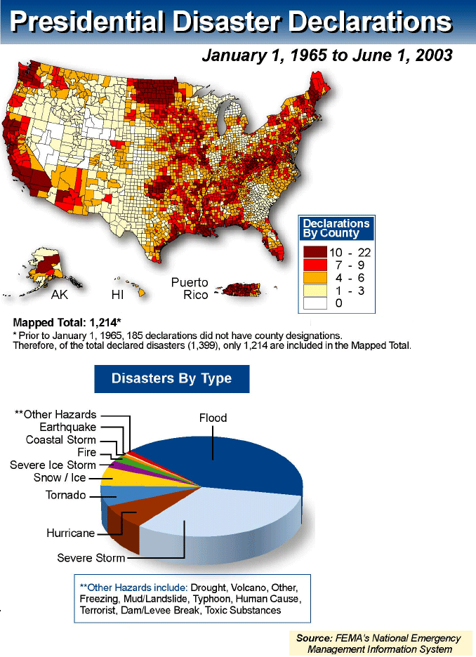
We’ve been innundated with disasters of late. Hurricanes, Fires, Blizzards. So where is it safe to live? FEMA, that agency of the 400% rack rate hotel rooms, has an answer. They have published a chart showing, by county, where the presidents have made disaster declarations since 1965. So where is it safe to live? The lowest number appear to be in Nevada, Utah, and Wyoming. Of course, there are also fewer lawyers there as well.

Turning to our local disasters. The “Topanga” Fire continues to burn (and it is smokey at our house). As of noon, they were indicating the fire has burned 20,600 acres and is 20% contained. The weather is cooling down, but there are still occasional hot spots (as I was driving home, there was one in Simi Valley, for example). The Governator had a very amusing news conference related to the fire. For those unaware, the Governator is in a big fight with the unions over such things as political speech and pension benefits. The firefighters don’t like him. However, the supervisors ordered 20 firefighters to stand behind him at the press conference. During the press conference, he was asked about this. His response? He said it was part of the presentation of the press conference. As for ordering: He orders a podium. The press is ordered by their bosses to cover the story. He saw no problem with having the officers ordered to stand there and look good (alas, an exact quote is not online). Sigh… he just doesn’t get it.

There is also a large fire burning in Burbank/Glendale. Now around 600 acres, it has burned up the Burbank hills. It is not immediately threatening homes yet, but could burn down into Glendale and Verdugo.

No fun, and the air is really bad here in the valley. But so far, the firefighters are doing a good job, and the weather will be cool-ish over the weekend. After that, it will heat up again? I know this without even consulting the weather channel. How? Just as matzah never breaks along the perforation, the High Holy Days are always the hottest days of the year!

Share